Ficheru:Qin empire 210 BCE.png

Contenido de la página no disponible en otros idiomas.
De Wikipedia

Qin_empire_210_BCE.png(555 × 545 píxels, tamañu de ficheru: 567 kB, triba MIME: image/png)

Esti ficheru ye de Wikimedia Commons y puen usalu otros proyeutos. La descripción de la páxina de descripción del ficheru s'amuesa darréu.

Resume

Descripción
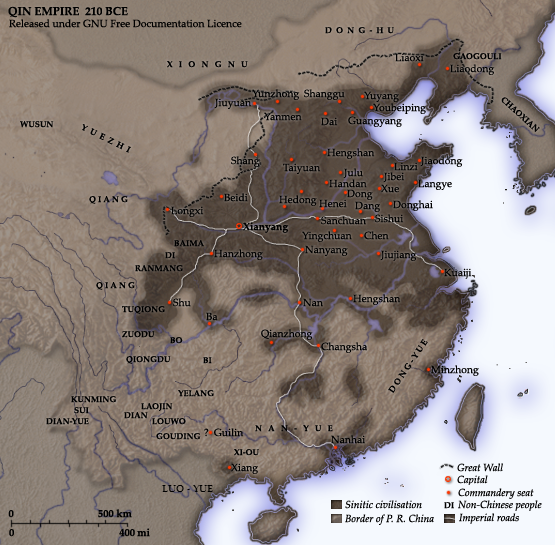
English: Map of the Qin Dynasty (in c. 210 BCE) — in China. ::*The first unifying Imperial dynasty of China. ::*The coloured territories show the approximate extent of Qin political control at the death of Emperor Qin Shi Huang in 210 BC.
As part of his unification of China in 221 BCE, Qin Shi Huang divided his empire into thirty six commanderies, each subdivided into a number of counties. The significance of the administrative reforms was its introduction of a uniformly centralised system of imperial control. At the death of Qin Shi Huang in 210 BCE, more commanderies were added to the original thirty six, and these are also shown on the map.
  • The system was followed by the Han Dynasty (206 BCE – 220 CE), though with a certain degree of compromise. Thereafter, the system became the norm for later dynasties and eventually evolved into the present administrative structure of Mainland China (see: Category: Political divisions of China.) The location of the Yellow River and commandery seats follows Tan Qixiang (ed.), Zhongguo lishi ditu (中国历史地图集), 1982. Note that the Yellow River is considerably to the north of its present flow. ;Credits Created and copyright (2006) by Yeu Ninje. Released under the GNU FDL. Originally uploaded to English Wikipedia by en:User:Yeu Ninje.
  • Han civilisation
    Han civilisation
Data 1982. (2006).
Fonte Self-published work by Itsmine
Autor Itsmine
Esta imagen debería volverse a crear como imágenes vectoriales SVG. Esto proporciona muchas ventajas, véase Commons:Media for cleanup (en inglés) para más información. Si ya hay una versión SVG de esta imagen disponible, por favor súbala a Commons. Tras subirla, reemplace esta plantilla con la plantilla {{vector version available|nuevo nombre de imagen.svg}} en esta imagen.

Llicencia

Yo, el titular de los drechos d'autor d'esta obra, la espublizo baxo les siguientes llicencies:
GNU head Autorízase la copia, distribución y/o cambéu d'esti documentu baxo los términos de la Llicencia de documentación llibre GNU, versión 1.2 o cualesquier otra que nel futuru espublice la Free Software Foundation; ensin seiciones invariables, testos de portada, nin testos de contraportada. S'inclúi una copia de la llicencia na seición titulada GNU Free Documentation License.
w:es:Creative Commons
reconocimientu compartir igual
Esti ficheru ta disponible baxo la llicencia Creative Commons Reconocimientu-Compartir igual 3.0 xenérica.
Ye llibre:
  • pa compartir – pa copiar, distribuir y comunicar públicamente la obra
  • pa remezclar – p'adautar la obra
Baxo les condiciones siguientes:
  • reconocimientu – Tienes de dar el créitu apropiáu, apurrir un enllaz a la llicencia ya indicar si realizasti dalgún cambéu. Puedes faelo de cualquier mou razonable ,pero non de manera que suxera l'encontu del autor pa ti o pal usu que faigas.
  • compartir igual – Si entemeces, tresformes o te bases nesti material, tienes de distribuir les tos contribuciones baxo la mesma llicencia o una compatible cola orixinal.
Esta etiqueta de llicencia s'amestó a esti ficheru como parte del anovamientu de la llicencia GFDL.
Pues seleicionar la llicencia que prefieras.

Pies

Añade una explicación corta acerca de lo que representa este archivo
A map of the Qin Dynasty circa 210 BCE.

Elementos representados en este archivo

representa a

Historial del ficheru

Calca nuna fecha/hora pa ver el ficheru como taba daquella.

Data/HoraMiniaturaDimensionesUsuariuComentariu
actual14:37 10 avi 2014Miniatura de la versión a fecha de 14:37 10 avi 2014555 × 545 (567 kB)Nguyen1310Update to include ''Luo-Yue'' (Vi: ''Lạc Việt'') a member of the Baiyue (100 Yue) peoples, on the map in northern Vietnam.
14:08 21 pay 2006Miniatura de la versión a fecha de 14:08 21 pay 2006555 × 545 (540 kB)Itsmine== Commentary == As part of his unification of China in 221 BC, Qin Shi Huang divided his empire into thirty six commanderies, each subdivided into a number of counties. The significance of the administrative reforms was its in

Les páxines siguientes usen esti ficheru:

Usu global del ficheru

Estes otres wikis usen esti ficheru:

Ver más usos globales d'esti ficheru.