
Ficheru:Botswana location map.svg

Tamañu de la vista previa PNG d'esti ficheru SVG: 577 × 600 pixels. Otres resoluciones: 231 × 240 pixels | 462 × 480 pixels | 739 × 768 pixels | 986 × 1024 pixels | 1971 × 2048 pixels | 974 × 1012 pixels.
Ficheru orixinal (ficheru SVG, 974 × 1012 píxels nominales, tamañu de ficheru: 314 kB)
Resume
| Descripción |
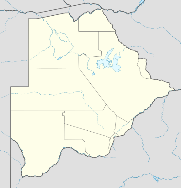
Deutsch: Positionskarte von Botsuana
Quadratische Plattkarte, N-S-Streckung 105 %. Geographische Begrenzung der Karte:
English: Location map of Botswana
Equirectangular projection, N/S stretching 105 %. Geographic limits of the map:
|
||
| Data | |||
| Fonte |
own work, using
|
||
| Autor | NordNordWest | ||
| SVG desarrollo | El código fuente de esta imagen SVG es válido. Este mapa fue creado con Inkscape, o con otro programa.
|

Llicencia
Yo, el titular de los drechos d'autor d'esta obra, la espublizo baxo les siguientes llicencies:

|
Autorízase la copia, distribución y/o cambéu d'esti documentu baxo los términos de la Llicencia de documentación llibre GNU, versión 1.2 o cualesquier otra que nel futuru espublice la Free Software Foundation; ensin seiciones invariables, testos de portada, nin testos de contraportada. S'inclúi una copia de la llicencia na seición titulada GNU Free Documentation License. |
Esti ficheru ta disponible baxo la llicencia Creative Commons Reconocimientu-Compartir igual 3.0 xenérica.
- Ye llibre:
- pa compartir – pa copiar, distribuir y comunicar públicamente la obra
- pa remezclar – p'adautar la obra
- Baxo les condiciones siguientes:
- reconocimientu – Tienes de dar el créitu apropiáu, apurrir un enllaz a la llicencia ya indicar si realizasti dalgún cambéu. Puedes faelo de cualquier mou razonable ,pero non de manera que suxera l'encontu del autor pa ti o pal usu que faigas.
- compartir igual – Si entemeces, tresformes o te bases nesti material, tienes de distribuir les tos contribuciones baxo la mesma llicencia o una compatible cola orixinal.
Pues seleicionar la llicencia que prefieras.
Historial del ficheru
Calca nuna fecha/hora pa ver el ficheru como taba daquella.
| Data/Hora | Miniatura | Dimensiones | Usuariu | Comentariu | |
|---|---|---|---|---|---|
| actual | 10:07 21 avi 2014 | | 974 × 1012 (314 kB) | Ravenpuff | Chobe District |
| 20:37 11 pay 2009 |  | 974 × 1012 (313 kB) | NordNordWest | ||
| 17:48 13 ago 2008 |  | 975 × 1012 (222 kB) | NordNordWest | {{Information |Description= {{de|Positionskarte von Botsuana}} Quadratische Plattkarte, N-S-Streckung 105 %. Geographische Begrenzung der Karte: * N: 17.3° S * S: 27.5° S * W: 19.4° O * O: 29.7° O {{en|Location map of [[:en:Botswana|B |
Usu del ficheru
Les páxines siguientes usen esti ficheru:
Usu global del ficheru
Estes otres wikis usen esti ficheru:
- Usu en af.wikipedia.org
- Maun
- Lobatse
- Francistown
- Ghanzi
- Kasane
- Mochudi
- Palapye
- Kanye
- Mahalapye
- Serowe
- Molepolole
- Tshabong
- Ramotswa
- Kalkfontein
- Selebi-Phikwe
- Gumare
- Masunga
- Tlokweng
- Jwaneng
- Bobonong
- Moshupa
- Orapa
- Thamaga
- Kang
- Sikwane
- Sowa, Botswana
- Zutswa
- Werda, Botswana
- Struizendam
- Tshane
- Vaalhoek
- Middelputs
- Bokspits
- Khuis
- Rapplespan
- Sir Seretse Khama Internasionale Lughawe
- Tuli-blok
- Makopong
- D'Kar
- Kasane Lughawe
- Francistown-lughawe
- Usu en am.wikipedia.org
- Usu en ar.wikipedia.org
- Usu en arz.wikipedia.org
- Usu en azb.wikipedia.org
Ver más usos globales d'esti ficheru.