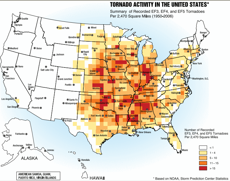
Ficheru:Tornado Alley.gif

Contenido de la página no disponible en otros idiomas.
De Wikipedia

Tornado_Alley.gif(742 × 582 píxels, tamañu de ficheru: 97 kB, triba MIME: image/gif)

Esti ficheru ye de Wikimedia Commons y puen usalu otros proyeutos. La descripción de la páxina de descripción del ficheru s'amuesa darréu.

File:Tornado Alley.svg es una versión vectorial de este archivo. Debería usarse esa versión en lugar de este archivo GIF, cuando sea mejor.

File:Tornado Alley.gif → File:Tornado Alley.svg

Para más información, lee Ayuda:SVG.

En otros idiomas
Alemannisch  Bahasa Indonesia  Bahasa Melayu  British English  català  čeština  dansk  Deutsch  eesti  English  español  Esperanto  euskara  français  Frysk  galego  hrvatski  Ido  italiano  lietuvių  magyar  Nederlands  norsk bokmål  norsk nynorsk  occitan  Plattdüütsch  polski  português  português do Brasil  română  Scots  sicilianu  slovenčina  slovenščina  suomi  svenska  Tiếng Việt  Türkçe  vèneto  Ελληνικά  беларуская (тарашкевіца)  български  македонски  нохчийн  русский  српски / srpski  татарча/tatarça  українська  ქართული  հայերեն  বাংলা  தமிழ்  മലയാളം  ไทย  한국어  日本語  简体中文  繁體中文  עברית  العربية  فارسی  +/−
Nueva imagen SVG

Resume

Descripción
English: A map of the frequency of F3 and greater intensity tornadoes by area. The darker colors highlight the areas typically known as a Tornado Alley.
Data
Fonte Image from Federal Emergency Management Agency, a United States government agency, booklet FEMA 320 Third Edition, Section 1, Figure 1.1, page 3, titled Taking Shelter from the Storm: Building a Safe Room Inside your House
Autor FEMA personnel

Llicencia

Public domain
This image is a work of a Federal Emergency Management Agency employee, taken or made as part of that person's official duties. As works of the U.S. federal government, all FEMA images are in the public domain in the United States. Additional media usage information may be found at https://www.fema.gov/photo-video-audio-use-guidelines

čeština  English  eesti  italiano  日本語  македонски  മലയാളം  Nederlands  polski  sicilianu  Türkçe  українська  简体中文  繁體中文  +/−

Pies

Añade una explicación corta acerca de lo que representa este archivo

Elementos representados en este archivo

representa a

Tornado Alley español

Historial del ficheru

Calca nuna fecha/hora pa ver el ficheru como taba daquella.

Data/HoraMiniaturaDimensionesUsuariuComentariu
actual17:25 2 och 2013Miniatura de la versión a fecha de 17:25 2 och 2013742 × 582 (97 kB)NodoveGreater city name resolution.
17:13 4 feb 2007Miniatura de la versión a fecha de 17:13 4 feb 2007550 × 406 (67 kB)TCYA map of the frequency of F3 and greater intensity tornadoes by area. The darker colors highlight the area typically known as Tornado Alley. '''Source:''' Image from a booklet from [http://www.fema.gov/index.shtm

La páxina siguiente usa esti ficheru:

Usu global del ficheru

Estes otres wikis usen esti ficheru: