
Ficheru:Relief Map of Norway.png
Tamañu d'esta previsualización: 564 × 599 pixels. Otres resoluciones: 226 × 240 pixels | 452 × 480 pixels | 723 × 768 pixels | 1200 × 1275 pixels.
Ficheru orixinal (1200 × 1275 píxels, tamañu de ficheru: 2,13 MB, triba MIME: image/png)
Resume
| Descripción |
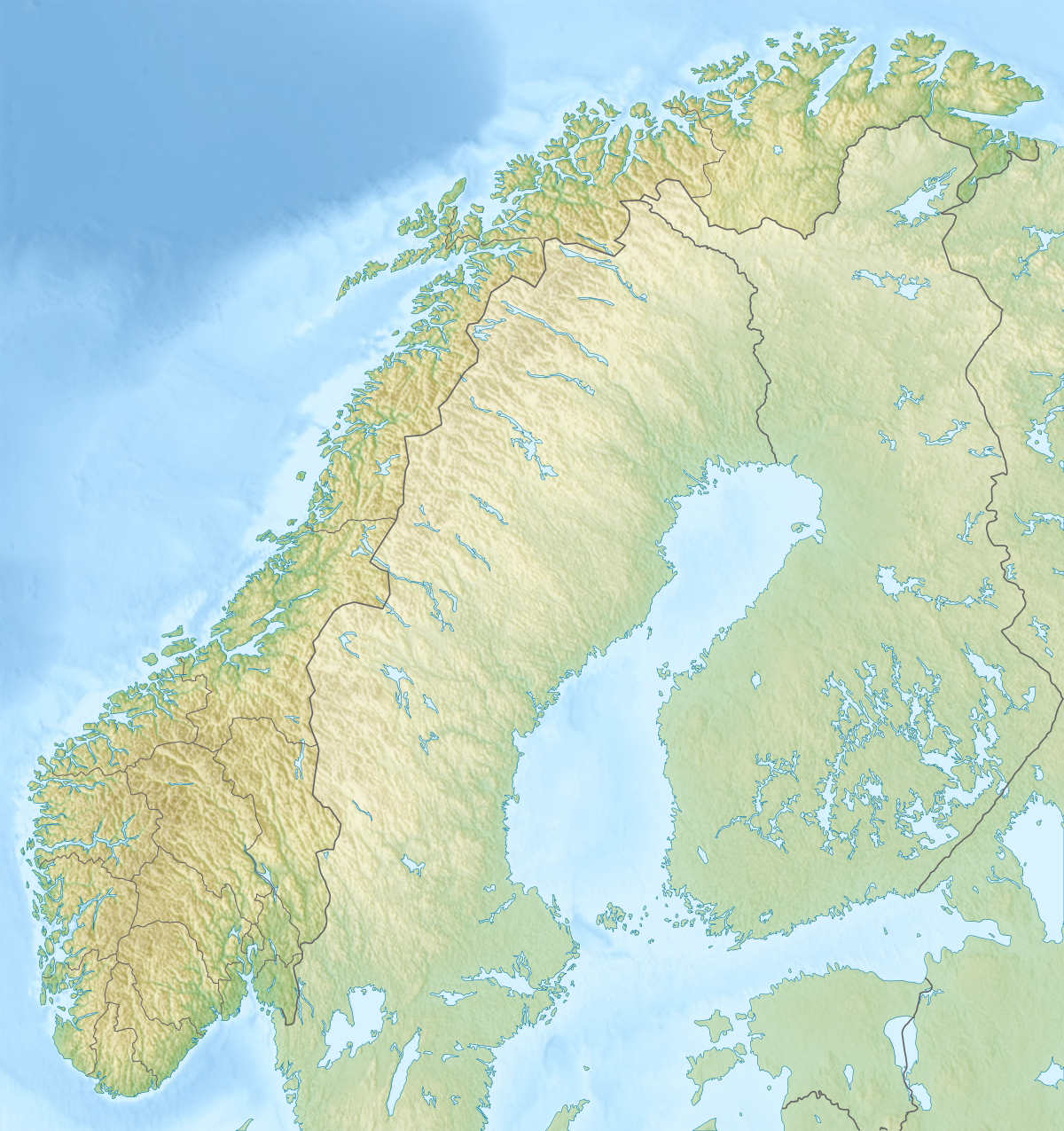
English: Relief map of Norway
Equirectangular projection, N/S stretching 210 %. Geographic limits of the map:
|
| Data | |
| Fonte |
|
| Autor | derivative work Виктор_В |

|
File:Norway rel location map.svg es una versión vectorial de este archivo. Debería usarse esa versión en lugar de este archivo PNG, cuando sea mejor.
File:Relief Map of Norway.png → File:Norway rel location map.svg
Para más información, lee Ayuda:SVG. |
 |
Llicencia
Yo, el titular de los drechos d'autor d'esta obra, la espublizo baxo les siguientes llicencies:

|
Autorízase la copia, distribución y/o cambéu d'esti documentu baxo los términos de la Llicencia de documentación llibre GNU, versión 1.2 o cualesquier otra que nel futuru espublice la Free Software Foundation; ensin seiciones invariables, testos de portada, nin testos de contraportada. S'inclúi una copia de la llicencia na seición titulada GNU Free Documentation License. |
Esti ficheru ta disponible baxo la llicencia Creative Commons Reconocimientu-Compartir igual 3.0 xenérica.
- Ye llibre:
- pa compartir – pa copiar, distribuir y comunicar públicamente la obra
- pa remezclar – p'adautar la obra
- Baxo les condiciones siguientes:
- reconocimientu – Tienes de dar el créitu apropiáu, apurrir un enllaz a la llicencia ya indicar si realizasti dalgún cambéu. Puedes faelo de cualquier mou razonable ,pero non de manera que suxera l'encontu del autor pa ti o pal usu que faigas.
- compartir igual – Si entemeces, tresformes o te bases nesti material, tienes de distribuir les tos contribuciones baxo la mesma llicencia o una compatible cola orixinal.
Pues seleicionar la llicencia que prefieras.
Historial del ficheru
Calca nuna fecha/hora pa ver el ficheru como taba daquella.
| Data/Hora | Miniatura | Dimensiones | Usuariu | Comentariu | |
|---|---|---|---|---|---|
| actual | 22:16 30 avi 2017 | | 1200 × 1275 (2,13 MB) | NordNordWest | upd 2018 |
| 18:01 10 avi 2010 |  | 1200 × 1275 (2,18 MB) | Виктор В | м | |
| 17:42 28 ago 2010 |  | 1200 × 1275 (2,4 MB) | Виктор В | Рельеф дна | |
| 16:42 28 ago 2010 |  | 1200 × 1275 (1,93 MB) | Виктор В | мелкие исправления | |
| 12:13 28 ago 2010 |  | 1200 × 1275 (2,01 MB) | Виктор В | == {{int:filedesc}} == {{Information |Description={{en|Relief map of Norway}} Equirectangular projection, N/S stretching 210 %. Geographic limits of the map: * N: 71.5° N * S: 57.6° N * W: 4.1° E * E: 31.6° E |Source=*[[:File:Norway loc |
Usu del ficheru
Les páxines siguientes usen esti ficheru:
Usu global del ficheru
Estes otres wikis usen esti ficheru:
- Usu en als.wikipedia.org
- Usu en ar.wikipedia.org
- Usu en arz.wikipedia.org
- Usu en azb.wikipedia.org
- Usu en ba.wikipedia.org
- Usu en be.wikipedia.org
- Usu en bg.wikipedia.org
Ver más usos globales d'esti ficheru.