
Ficheru:Great Basin definition map.gif

Tamañu d'esta previsualización: 437 × 599 pixels. Otres resoluciones: 175 × 240 pixels | 572 × 784 pixels.
Ficheru orixinal (572 × 784 píxels, tamañu de ficheru: 50 kB, triba MIME: image/gif)
Resume
| Descripción |
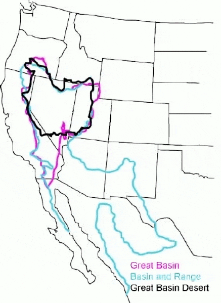
English: The Great Basin can be defined hydrographically (in purple), topographically (in blue), or biologically (in black). |
| Data | (UTC) |
| Fonte |
Este archivo deriva de: GB-Definition-Map.jpg:  |
| Autor |
|
Llicencia
Original:
| This image or media file contains material based on a work of a National Park Service employee, created as part of that person's official duties. As a work of the U.S. federal government, such work is in the public domain in the United States. See the NPS website and NPS copyright policy for more information. |
Cleanup:
| Esti ficheru ta disponible baxo la llicencia Creative Commons de Dedicatoria universal al dominiu públicu CC0 1.0. | |
| La persona qu'asoció una obra con esti documentu dedicó esa obra al dominiu públicu per aciu de la cesión mundial de los sos drechos baxo les lleis de drechos d'autor, incluyendo tolos los drechos llegales rellacionaos y axacentes, dientro del ámbitu permitíu pola llei. Pue copiar, camudar, distribuir y reproducir la obra, incluyendo con oxetivos comerciales, ensin pidir permisu.
|
Rexistru de xubíes orixinal
This image is a derivative work of the following images:
- File:GB-Definition-Map.jpg licensed with PD-USGov-NPS
- 2008-01-02T14:23:51Z Psemper 286x392 (17013 Bytes) {{Information |Description= |Source=http://en.wikipedia.org/wiki/Image:GB-Definition-Map.jpg |Date= |Author= |Permission= |other_versions= }}
Uploaded with derivativeFX
Historial del ficheru
Calca nuna fecha/hora pa ver el ficheru como taba daquella.
| Data/Hora | Miniatura | Dimensiones | Usuariu | Comentariu | |
|---|---|---|---|---|---|
| actual | 05:38 23 mar 2024 | | 572 × 784 (50 kB) | Hike395 | optimize gif |
| 03:39 23 mar 2024 |  | 572 × 784 (115 kB) | Hike395 | == {{int:filedesc}} == {{Information |Description={{en|The {{w|Great Basin}} can be defined hydrographically (in purple), topographically (in blue), or biologically (in black).}} |Source={{Derived from|GB-Definition-Map.jpg|display=50}} |Date=2024-03-23 03:38 (UTC) |Author=* File:GB-Definition-Map.jpg: U.S. National Park Service * cleanup: [[User:{{subst:REVISIONUSER}}|{{subst:REVISIONUSER}}]] |Permission= |other_versions= }} == {{int:license-header}} == Origi... |
Usu del ficheru
La páxina siguiente usa esti ficheru:
Usu global del ficheru
Estes otres wikis usen esti ficheru:
- Usu en ar.wikipedia.org
- Usu en arz.wikipedia.org
- Usu en az.wikipedia.org
- Usu en bg.wikipedia.org
- Usu en ca.wikipedia.org
- Usu en de.wikipedia.org
- Usu en en.wikipedia.org
- Usu en es.wikipedia.org
- Usu en eu.wikipedia.org
- Usu en gd.wikipedia.org
- Usu en he.wikipedia.org
- Usu en hu.wikipedia.org
- Usu en hy.wikipedia.org
- Usu en ja.wikipedia.org
- Usu en ka.wikipedia.org
- Usu en nl.wikipedia.org
- Usu en pt.wikipedia.org
- Usu en ro.wikipedia.org
- Usu en ru.wikipedia.org
- Usu en simple.wikipedia.org
- Usu en sv.wikipedia.org
- Usu en tr.wikipedia.org
- Usu en uk.wikipedia.org
- Usu en vi.wikipedia.org
- Usu en war.wikipedia.org
- Usu en www.wikidata.org