
Ficheru:European Union without internal borders.svg

Tamañu de la vista previa PNG d'esti ficheru SVG: 713 × 600 pixels. Otres resoluciones: 285 × 240 pixels | 571 × 480 pixels | 913 × 768 pixels | 1218 × 1024 pixels | 2435 × 2048 pixels | 2045 × 1720 pixels.
Ficheru orixinal (ficheru SVG, 2045 × 1720 píxels nominales, tamañu de ficheru: 7,34 MB)
Resume
| Descripción |
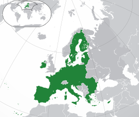
Xunión Europea (mapa d'allugamientu) (verde) Xunión Europea
(buxu) Europa
(plata) Surrounding region
|
| Data | |
| Fonte |
|
| Autor | User:Robert Laymont |
| Otres versiones |
|
.svg)

Llicencia
Yo, el titular de los drechos d'autor d'esta obra, la espublizo baxo les siguientes llicencies:
Esti ficheru ta disponible baxo la llicencia Creative Commons Reconocimientu-Compartir igual 3.0 xenérica.
- Ye llibre:
- pa compartir – pa copiar, distribuir y comunicar públicamente la obra
- pa remezclar – p'adautar la obra
- Baxo les condiciones siguientes:
- reconocimientu – Tienes de dar el créitu apropiáu, apurrir un enllaz a la llicencia ya indicar si realizasti dalgún cambéu. Puedes faelo de cualquier mou razonable ,pero non de manera que suxera l'encontu del autor pa ti o pal usu que faigas.
- compartir igual – Si entemeces, tresformes o te bases nesti material, tienes de distribuir les tos contribuciones baxo la mesma llicencia o una compatible cola orixinal.

|
Autorízase la copia, distribución y/o cambéu d'esti documentu baxo los términos de la Llicencia de documentación llibre GNU, versión 1.2 o cualesquier otra que nel futuru espublice la Free Software Foundation; ensin seiciones invariables, testos de portada, nin testos de contraportada. S'inclúi una copia de la llicencia na seición titulada GNU Free Documentation License. |
Pues seleicionar la llicencia que prefieras.
Historial del ficheru
Calca nuna fecha/hora pa ver el ficheru como taba daquella.
| Data/Hora | Miniatura | Dimensiones | Usuariu | Comentariu | |
|---|---|---|---|---|---|
| actual | 10:19 23 may 2020 | | 2045 × 1720 (7,34 MB) | Thayts | Fixed viewport outline on inserted map |
| 04:12 1 feb 2020 |  | 2045 × 1720 (7,27 MB) | Rob984 | UK and Gibraltar have left the EU. New base which includes all of Portugal's islands within frame, as well as Arctic Russian islands part of Europe. | |
| 01:50 10 mar 2017 |  | 2045 × 1720 (7,3 MB) | Geom10 | fixed Cyprus and disputed borders | |
| 01:23 10 mar 2017 |  | 2045 × 1720 (7,32 MB) | Geom10 | fixed Cyprus and Slovenia | |
| 15:25 9 ago 2014 |  | 2045 × 1720 (7,32 MB) | Rob984 | Improved version: More accurate coastline, borders, etc. Added Gradient and Longitude and latitude lines. Sudan border. | |
| 07:30 1 xnt 2013 |  | 2045 × 1720 (2,46 MB) | Klodde | Croatia | |
| 10:20 13 ago 2012 |  | 2045 × 1720 (2,46 MB) | Robert Laymont | Antarctica now appears correctly in the minimap. | |
| 07:13 13 ago 2012 |  | 2045 × 1720 (2,48 MB) | Robert Laymont |
Usu del ficheru
La páxina siguiente usa esti ficheru:
Usu global del ficheru
Estes otres wikis usen esti ficheru:
- Usu en ar.wikipedia.org
- Usu en arz.wikipedia.org
- Usu en diq.wikipedia.org
- Usu en en.wikipedia.org
- Usu en eu.wikipedia.org
- Usu en fr.wikipedia.org
- Usu en fr.wikinews.org
- Usu en ga.wikipedia.org
- Usu en gl.wikipedia.org
- Usu en ha.wikipedia.org
- Usu en ia.wikipedia.org
- Usu en incubator.wikimedia.org
- Usu en kab.wikipedia.org
- Usu en kk.wikipedia.org
- Usu en ku.wikipedia.org
- Usu en lmo.wikipedia.org
- Usu en mdf.wikipedia.org
- Usu en pt.wikipedia.org
- Usu en www.wikidata.org