Ficheru:Carolingian empire 814.svg

Contenido de la página no disponible en otros idiomas.
De Wikipedia

Ficheru orixinal(ficheru SVG, 1092 × 1057 píxels nominales, tamañu de ficheru: 237 kB)

Esti ficheru ye de Wikimedia Commons y puen usalu otros proyeutos. La descripción de la páxina de descripción del ficheru s'amuesa darréu.

Resume

Descripción
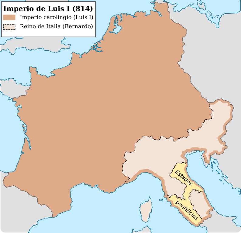
Español: Imperio carolingio al ascenso del emperador Luis I (814)
Data
Fonte

Trabayu propiu

  • [1] I territori di Tuscania, Norchia, Marta, Viterbo, Ferento, Bagnoregio, Orvieto e Savana, interessati dal nostro studio sulle murature, oltre ai centri più settentrionali di Rosellae e Populonia, venivano annessi nel 787 al Patrimonio di San Pietro.
  • [2] Adriano ricevette la promessa di altri miglioramenti territorali, che però furono concessi formalmente solo nel 787, quando Carlo gli aggiuducò la Toscana meridionale (Viterbo, Orvieto, Soana) con le città maritime di Grosseto (Rosellae) e di Piombino (Populonia).
  • [3] After the long paragraph in de Ludovicianum that bgins with Ravenna and ends with Sabina, we read a clause that says, "Likewise in Lombard Tuscny Città di Castello, Orvieto, Bagnorea, Farentum, Viterbo, Orchia, Marta, Toscanella, Sovana, Populonia, Rosellae [Groseto]. Lindner and Gundlach thought that this passage must date from 781, but most scholars have placed it in 787. [4]: The duchy of Rome had never extended into Lombard Tuscany, and in 781 the precise northern frontir of the duchy itself was fixed and defined at its ancient limits in suburbicarian, or Roman Tuscany. Then Charlemagne added to the Republic a section of southern and coastal Lombard Tuscany which he detached from the regnum. It seems, again, that Hadrian was being compensated for the fact that the Quierzy-Rome promise was not literally fulfilled. The Republic received lands it had never held in return for abandonig claims that Charlemagne could no honor.
  • [5]: The 817 treaty is the first well-authenticated document to define the temporal power of the of the popes and their relations with the Frankish monarchy. Although it lists places and areas, and does not try to mark off a frontier for the Papal State, we know from the 'division of the kingdom' of 806 that a frontier was consdered to exist. The frontier of 817 reflects the cutting down by Charlemagne of Hadrian's original ambitious claims. It ran from the Tyrrhenian coast at Massa Marittima (Populonia) and Rosella of Lake Orbetello and inland south of Lake Trasimene, thus including a large part of Lombard Tuscany, but running far south of the early Roman claims. It included the Via Amerina, which skirted the important castle of Gallese, and went though Amelia to Perugia to rejoin the Via Flaminia by way of Gubbio, at Scheggia. This was 'Roman' corridor across the Apennines through Fossombrone and Urbino in order to communicate with the exarchate of Ravenna, which with Pentapolis is again assigned to papal jurisdiction. The pact says explicitly that this jurisdiction is to be the same as that exercised by the pope in Rome and its duchy. Near Rome, the grant of the small mountain area of Sabina and Riet was maintained: this was the only part of Charlemagne's grant of the duchy of Spoleto actually assigned to the popes. Apart from this they ruled 'Campagna' as far south as the river Garigliano.
  • [6] A further landmark was the pactum which, in 817, the Emperor Louis the Pious made which Pope Paschal I, a text of which survives. Although much interpolated, it envisaged a more southerly limit to the papal lands, running approximately from Populonia to Orvieto and Perigia, and hence northwards to include Bologna and Ferrara; it finally followed the River Adige to the sea. Of the duchy of Spoleto, only Sabina remained to the papacy, but lands near Naples and Salerno were added, as, lmost certainly, were the islands of Sardinia and Sicily.
Autor Trasamundo
Otres versiones

Llicencia

Yo, el titular de los drechos d'autor d'esta obra, la espublizo baxo les siguientes llicencies:
GNU head Autorízase la copia, distribución y/o cambéu d'esti documentu baxo los términos de la Llicencia de documentación llibre GNU, versión 1.2 o cualesquier otra que nel futuru espublice la Free Software Foundation; ensin seiciones invariables, testos de portada, nin testos de contraportada. S'inclúi una copia de la llicencia na seición titulada GNU Free Documentation License.
w:es:Creative Commons
reconocimientu compartir igual
Este archivo se encuentra bajo la licencia Creative Commons Attribution-Share Alike 3.0 Unported, 2.5 Generic, 2.0 Generic and 1.0 Generic
Ye llibre:
  • pa compartir – pa copiar, distribuir y comunicar públicamente la obra
  • pa remezclar – p'adautar la obra
Baxo les condiciones siguientes:
  • reconocimientu – Tienes de dar el créitu apropiáu, apurrir un enllaz a la llicencia ya indicar si realizasti dalgún cambéu. Puedes faelo de cualquier mou razonable ,pero non de manera que suxera l'encontu del autor pa ti o pal usu que faigas.
  • compartir igual – Si entemeces, tresformes o te bases nesti material, tienes de distribuir les tos contribuciones baxo la mesma llicencia o una compatible cola orixinal.
Pues seleicionar la llicencia que prefieras.

Pies

Añade una explicación corta acerca de lo que representa este archivo

Elementos representados en este archivo

representa a

tipo de archivo español

image/svg+xml

7a1ce8a10874ee75e995e1873c11994f654d78fa

243 154 Byte

1057 píxel

1092 píxel

Historial del ficheru

Calca nuna fecha/hora pa ver el ficheru como taba daquella.

Data/HoraMiniaturaDimensionesUsuariuComentariu
actual12:01 28 och 2021Miniatura de la versión a fecha de 12:01 28 och 20211092 × 1057 (237 kB)Rowanwindwhistlerminor change in sea lines so hide them in the frame side
11:59 28 och 2021Miniatura de la versión a fecha de 11:59 28 och 20211092 × 1057 (235 kB)RowanwindwhistlerLighter colours, fake text added for better rendering in articles (real text is now hidden).
08:29 4 may 2016Miniatura de la versión a fecha de 08:29 4 may 20161091 × 1053 (185 kB)RowanwindwhistlerSofter colours, bigger font size
22:03 22 abr 2016Miniatura de la versión a fecha de 22:03 22 abr 20161091 × 1053 (185 kB)RowanwindwhistlerCleaner shapes, some colours from https://en.wikipedia.org/wiki/Wikipedia:WikiProject_Maps/Conventions
18:24 13 mar 2010Miniatura de la versión a fecha de 18:24 13 mar 20101091 × 1053 (734 kB)Trasamundo{{Information |Description={{es|1=Imperio carolingio al ascenso del emperador Luis I (814)}} |Source={{own}} |Author=Trasamundo |Date=13 March 2010 |Permission= |other_versions= }} Category:Maps of the Carolingian Empire

La páxina siguiente usa esti ficheru:

Usu global del ficheru

Estes otres wikis usen esti ficheru:

Metadatos