
Ficheru:Amarnamap.png

Tamañu d'esta previsualización: 772 × 599 pixels. Otres resoluciones: 309 × 240 pixels | 619 × 480 pixels | 782 × 607 pixels.
Ficheru orixinal (782 × 607 píxels, tamañu de ficheru: 743 kB, triba MIME: image/png)
Resume
| Descripción |
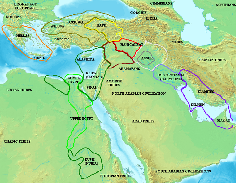
English: Map of the ancient Near East during the Amarna period, showing the great powers of the period: Egypt (green), Hatti (yellow), the Kassite kingdom of Babylon (purple), Assyria (grey), and Mittani (red). Lighter areas show direct control, darker areas represent spheres of influence. The extent of the Achaean/Mycenaean civilization is shown in orange.
On the map above: the territory between Medes and Iberia was called Ararat or Armenia, around the lake Van.
Русский: Карта Восточного Средиземноморья в Амарнский период (XIV век до н. э.). Территория Египта обведена зелёным, Митанни — красным, Хатти — жёлтым (покорённые ими территории обозначены более тёмными контурами того же цвета). |
||
| Data | |||
| Fonte |
|
||
| Autor | Briangotts |

Llicencia
Yo, el titular de los drechos d'autor d'esta obra, la espublizo baxo la siguiente llicencia:

|
Autorízase la copia, distribución y/o cambéu d'esti documentu baxo los términos de la Llicencia de documentación llibre GNU, versión 1.2 o cualesquier otra que nel futuru espublice la Free Software Foundation; ensin seiciones invariables, testos de portada, nin testos de contraportada. S'inclúi una copia de la llicencia na seición titulada GNU Free Documentation License. |
| Esti ficheru ta disponible baxo la llicencia Creative Commons Reconocimientu-Compartir igual 3.0 xenérica. | ||
| ||
| Esta etiqueta de llicencia s'amestó a esti ficheru como parte del anovamientu de la llicencia GFDL. |
Historial del ficheru
Calca nuna fecha/hora pa ver el ficheru como taba daquella.
| Data/Hora | Miniatura | Dimensiones | Usuariu | Comentariu | |
|---|---|---|---|---|---|
| actual | 09:55 3 avi 2006 | | 782 × 607 (743 kB) | Electionworld | {{ew|en|Briangotts}} Map of the ancient Near East during the Amarna period, showing the great powers of the period: Egypt (green), Hatti (yellow), the Kassite kingdom of Babylon (purple), Assyria (grey), and Mittani (red). |
Usu del ficheru
La páxina siguiente usa esti ficheru:
Usu global del ficheru
Estes otres wikis usen esti ficheru:
- Usu en am.wikipedia.org
- Usu en ar.wikipedia.org
- Usu en ba.wikipedia.org
- Usu en be.wikipedia.org
- Usu en bs.wikipedia.org
- Usu en ca.wikipedia.org
- Usu en diq.wikipedia.org
- Usu en el.wikipedia.org
- Usu en en.wikipedia.org
- Usu en es.wikipedia.org
- Usu en eu.wikipedia.org
- Usu en fi.wikipedia.org
- Usu en fr.wikipedia.org
- Usu en fy.wikipedia.org
- Usu en he.wikipedia.org
- Usu en hu.wikipedia.org
- Usu en hy.wikipedia.org
- Usu en hyw.wikipedia.org
- Usu en id.wikipedia.org
- Usu en ja.wikipedia.org
- Usu en jv.wikipedia.org
- Usu en mk.wikipedia.org
- Usu en ml.wikipedia.org
- Usu en nl.wikipedia.org
- Usu en no.wikipedia.org
Ver más usos globales d'esti ficheru.