
Ficheru:Abbasid Caliphate 891-892.png

Tamañu d'esta previsualización: 800 × 382 pixels. Otres resoluciones: 320 × 153 pixels | 640 × 306 pixels | 1024 × 490 pixels | 1280 × 612 pixels | 3054 × 1460 pixels.
Ficheru orixinal (3054 × 1460 píxels, tamañu de ficheru: 1,44 MB, triba MIME: image/png)
Resume
| Descripción |
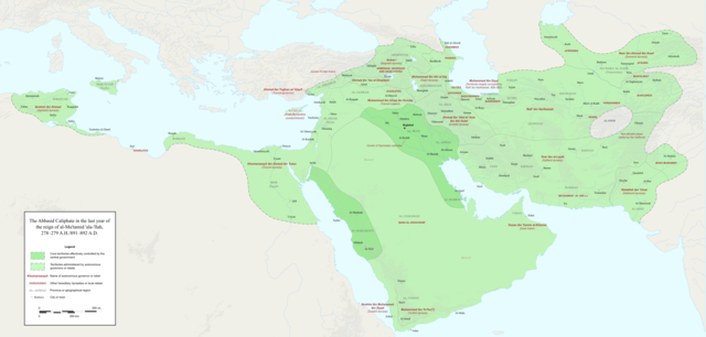
English: Map of the Abbasid Caliphate at the end of the reign of al-Mu'tamid in 891-892. Dark green denotes provinces under the effective control of the central government; light green denotes provinces under the control of autonomous governors or rebels.
The core Abbasid territories include Shahrazur, Darabadh, al-Samaghan, Hulwan, Masabadhan, Mihrijanqadhaq, the Euphrates districts, and Qarqisiyya (al-Tabari v. 37, p. 98; Bianquis p. 96). Map originally created as an .SVG file in Inkscape and converted to .PNG for size reasons. Background topography taken from DEMIS Mapserver, which are public domain. Works Cited:
|
| Data | |
| Fonte | Trabayu propiu |
| Autor | Ro4444 |
| Otres versiones |
 |
Llicencia
Yo, el titular de los drechos d'autor d'esta obra, la espublizo baxo la siguiente llicencia:
Este archivo está disponible bajo la licencia Creative Commons Attribution-Share Alike 4.0 International.
- Ye llibre:
- pa compartir – pa copiar, distribuir y comunicar públicamente la obra
- pa remezclar – p'adautar la obra
- Baxo les condiciones siguientes:
- reconocimientu – Tienes de dar el créitu apropiáu, apurrir un enllaz a la llicencia ya indicar si realizasti dalgún cambéu. Puedes faelo de cualquier mou razonable ,pero non de manera que suxera l'encontu del autor pa ti o pal usu que faigas.
- compartir igual – Si entemeces, tresformes o te bases nesti material, tienes de distribuir les tos contribuciones baxo la mesma llicencia o una compatible cola orixinal.
Historial del ficheru
Calca nuna fecha/hora pa ver el ficheru como taba daquella.
| Data/Hora | Miniatura | Dimensiones | Usuariu | Comentariu | |
|---|---|---|---|---|---|
| actual | 23:18 3 avi 2017 | | 3054 × 1460 (1,44 MB) | Ro4444 | Further color corrections |
| 22:50 3 avi 2017 |  | 3054 × 1460 (1,44 MB) | Ro4444 | Color correction | |
| 21:11 3 avi 2017 |  | 3054 × 1460 (1,44 MB) | Ro4444 | User created page with UploadWizard |
Usu del ficheru
Nun hai páxines qu'usen esti ficheru.
Usu global del ficheru
Estes otres wikis usen esti ficheru:
- Usu en ar.wikipedia.org
- Usu en de.wikiversity.org
- Usu en en.wikipedia.org
- Usu en en.wikibooks.org
- Usu en et.wikipedia.org
- Usu en fa.wikipedia.org
- Usu en hy.wikipedia.org
- Usu en id.wikipedia.org
- Usu en ja.wikipedia.org
- Usu en no.wikipedia.org
- Usu en pt.wikipedia.org
- Usu en sco.wikipedia.org
- Usu en uk.wikipedia.org
- Usu en uz.wikipedia.org
- Usu en zh.wikipedia.org