
Ficheru:1815 tambora explosion.png

Tamañu d'esta previsualización: 800 × 358 pixels. Otres resoluciones: 320 × 143 pixels | 640 × 286 pixels | 1200 × 537 pixels.
Ficheru orixinal (1200 × 537 píxels, tamañu de ficheru: 720 kB, triba MIME: image/png)
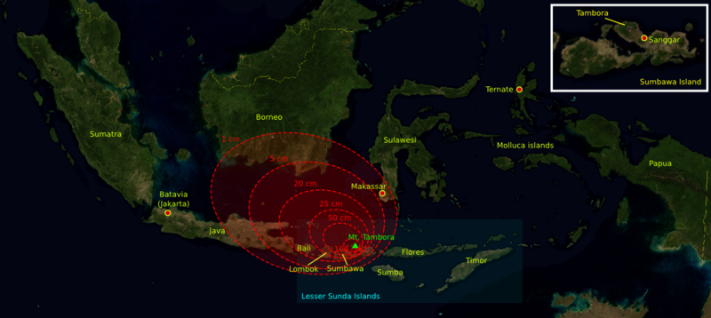
| Descripción | The 1815 Mount Tambora eruption. The red areas are maps of the thickness of volcanic ashfall. | ||||||||
| Fonte | The base map was taken from NASA picture Image:Indonesia_BMNG.png and the isopach maps were traced from Oppenheimer (2003).[1] | ||||||||
| Autor | myself | ||||||||
| Permisu (Cómo reutilizar esti ficheru) |
|
||||||||
| Otres versiones |
Deutsch: Von diesem Bild existieren die folgenden Bildbearbeitungen aus der Bilderwerkstatt: English: Retouched versions of this picture from the german Graphic Lab:
|

References
- ↑ Oppenheimer, Clive (2003). "Climatic, environmental and human consequences of the largest known historic eruption: Tambora volcano (Indonesia) 1815". Progress in Physical Geography 27 (2): 230-259.
Historial del ficheru
Calca nuna fecha/hora pa ver el ficheru como taba daquella.
| Data/Hora | Miniatura | Dimensiones | Usuariu | Comentariu | |
|---|---|---|---|---|---|
| actual | 13:14 11 och 2006 | | 1200 × 537 (720 kB) | Indon~commonswiki | {{Information |Description= The 1815 Mount Tambora eruption. The red areas are maps of the thickness of vulcanic ashfall. |Source=The base map was taken from NASA picture Image:Indonesia_BMNG.png and the isopach maps were traced |
| 13:12 11 och 2006 |  | 1200 × 537 (720 kB) | Indon~commonswiki | ||
| 12:50 11 och 2006 |  | 1200 × 537 (686 kB) | Indon~commonswiki | {{Information |Description= The 1815 Mount Tambora eruption. The red areas are w:isopach maps of the density of fallen vulcanic ashes. |Source=The base map was taken from NASA picture Image:Indonesia_BMNG.png and the isopach |
Usu del ficheru
La páxina siguiente usa esti ficheru:
Usu global del ficheru
Estes otres wikis usen esti ficheru:
- Usu en ar.wikipedia.org
- Usu en be-tarask.wikipedia.org
- Usu en ca.wikipedia.org
- Usu en de.wikipedia.org
- Usu en en.wikipedia.org
- Usu en es.wikipedia.org
- Usu en gor.wikipedia.org
- Usu en id.wikipedia.org
- Usu en lt.wikipedia.org
- Usu en ms.wikipedia.org
- Usu en ro.wikipedia.org
- Usu en sh.wikipedia.org
- Usu en sv.wikipedia.org
- Usu en th.wikipedia.org
- Usu en tr.wikipedia.org