
Ficheru:Zhenghe-sailing-chart.gif
Tamañu d'esta previsualización: 800 × 570 pixels. Otres resoluciones: 320 × 228 pixels | 640 × 456 pixels | 1024 × 730 pixels | 1280 × 912 pixels | 1454 × 1036 pixels.
Ficheru orixinal (1454 × 1036 píxels, tamañu de ficheru: 174 kB, triba MIME: image/gif)
Resume
| Descripción |
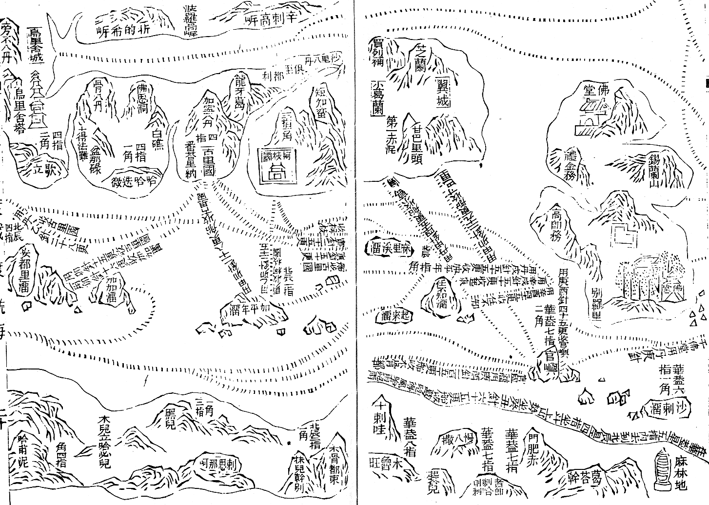
English: Part of the Wu bei zhi chart of Zheng He showing the west coast of India along the top, Ceylon top right and Africa along the bottom. The sailing directions are shown using zhen lu compass directions.
Русский: Фрагмент навигационной карты ("карта Мао Куня") из энциклопедии "Убэй чжи", показывающий бассейн Аравийского моря.
Север слева, восток вверху. В правом верхнем углу - остров Цейлон (錫蘭山,Силаньшань - остров/гора Силань); в правом нижнем углу - порт Малинди (麻林地, Малиньди) |
| Data | Early 15th century map. Published in Wubei Zhi in 1628. |
| Fonte | Wubei Zhi |
| Autor |
Llicencia
|
Este material está en dominio público en los demás países donde el derecho de autor se extiende por 100 años (o menos) tras la muerte del autor. | |
| Esta obra ha sido identificada como libre de las restricciones conocidas en virtud del derecho de autor, incluyendo todos los derechos conexos. | |
Rexistru de xubíes orixinal
Aquí se muestra la página de descripción original. Los siguientes nombres de usuario se refieren a en.wikipedia.
- 2008-07-04 22:54 Chris55 1454×1036× (177834 bytes) Part of the Wu bei zhi chart of Zheng He showing the west coast of India along the top, Ceylon top right and Africa along the bottom. The sailing directions are shown using zhen lu compass directions.
Historial del ficheru
Calca nuna fecha/hora pa ver el ficheru como taba daquella.
| Data/Hora | Miniatura | Dimensiones | Usuariu | Comentariu | |
|---|---|---|---|---|---|
| actual | 04:30 1 set 2009 | | 1454 × 1036 (174 kB) | Rockfang | {{Information |Description={{en|Part of the Wu bei zhi chart of Zheng He showing the west coast of India along the top, Ceylon top right and Africa along the bottom. The sailing directions are shown using zhen lu compass directions.}} |Source=Transferred |
Usu del ficheru
La páxina siguiente usa esti ficheru:
Usu global del ficheru
Estes otres wikis usen esti ficheru:
- Usu en azb.wikipedia.org
- Usu en en.wikipedia.org
- Usu en en.wikiquote.org
- Usu en es.wikipedia.org
- Usu en ja.wikipedia.org
- Usu en ro.wikipedia.org
- Usu en ru.wikipedia.org
- Usu en sl.wikipedia.org
- Usu en ta.wikipedia.org
- Usu en uk.wikipedia.org
- Usu en vi.wikipedia.org
- Usu en vi.wikibooks.org