Ficheru:Wostok-Station core32.jpg
Contenido de la página no disponible en otros idiomas.
De Wikipedia

Ficheru orixinal(1000 × 644 píxels, tamañu de ficheru: 89 kB, triba MIME: image/jpeg)

Esti ficheru ye de Wikimedia Commons y puen usalu otros proyeutos. La descripción de la páxina de descripción del ficheru s'amuesa darréu.

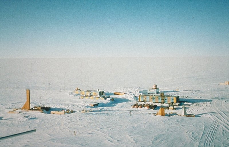
Descripción Wostok-Station (NOAA), photo by Todd Sowers, Lamont-Doherty Earth Observatory (LDEO), Columbia University, Palisades, New York, for NOAA. The Vostok site was chosen by the Soviet Union for the deep coring possibilities it offered. French and, later, American scientists became interested in the Soviet research and began to participate in coring activities at the site. This panoramic photo of Vostok Station shows the layout of the camp. The striped building on the left is the power station while the striped building on the right is where researchers sleep and take meals. The building in the background with the red- and white-striped ball on top is the meteorology building. Caves were dug into the ice sheet for storage, keeping cores at an ideal -55 degrees C year round.
Data (date attribute of the source file)
Fonte http://www.ngdc.noaa.gov/paleo/slides/slideset/15/15_300_slide.html
Autor Todd Sowers, Lamont-Doherty Earth Observatory (LDEO), Columbia University, Palisades, New York for NOAA
Permisu
(Cómo reutilizar esti ficheru)
Public domain
Esta imagen es de dominio público porque contiene material que vino originalmente de la Administración Nacional Oceánica y Atmosférica de los Estados Unidos de América, recibidas o hechas en el curso de las funciones oficiales de un empleado.

العربية  čeština  Deutsch  Zazaki  English  español  eesti  suomi  français  hrvatski  magyar  italiano  日本語  한국어  македонски  മലയാളം  Plattdüütsch  Nederlands  polski  português  română  русский  sicilianu  slovenščina  Türkçe  Tiếng Việt  简体中文  繁體中文  +/−

Posición de la cámara78° 27′ 52″ S, 106° 50′ 50″ E Kartographer map based on OpenStreetMap.Ubicación de esta y otras imágenes en: OpenStreetMapinfo

Rexistru de xubíes orixinal

(All user names refer to de.wikipedia)

  • 2004-07-02 17:33 Srbauer 768×494×8 (45575 bytes) Wostok-Station (NOAA)

taken from de.wikipedia; description page is/was here. Original uploader was Srbauer at de.wikipedia

Pies

Añade una explicación corta acerca de lo que representa este archivo
Panoramic view of the Russian Vostok Station, Antarctica, 2001.

Elementos representados en este archivo

representa a

78°27'51.998"S, 106°50'49.999"E

tipo de archivo español

image/jpeg

Historial del ficheru

Calca nuna fecha/hora pa ver el ficheru como taba daquella.

Data/HoraMiniaturaDimensionesUsuariuComentariu
actual20:21 5 abr 2007Miniatura de la versión a fecha de 20:21 5 abr 20071000 × 644 (89 kB)Raul6
12:16 4 feb 2007Miniatura de la versión a fecha de 12:16 4 feb 2007768 × 494 (45 kB)Hardscarf{{Information |Description=Wostok-Station (NOAA) Quelle: http://www.ngdc.noaa.gov/paleo/slides/slideset/15/15_300_slide.html Lizenz: PD Beschreibung: Vostok Site The Vostok site was chosen by the Soviet Union for the deep coring possibilities it offer

Les páxines siguientes usen esti ficheru:

Usu global del ficheru

Estes otres wikis usen esti ficheru:

Ver más usos globales d'esti ficheru.

Metadatos