
Ficheru:Western Aleutians.png

Ficheru orixinal (826 × 478 píxels, tamañu de ficheru: 10 kB, triba MIME: image/png)
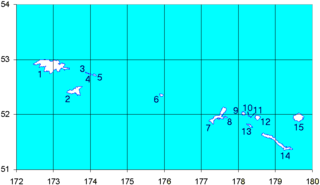
Map of the Western Aleutian Islands. Prepared from Digital Chart of the World (DCW) data. Latitudes are North, longitudes are East. The 52nd parallel is to scale.
1-5 - Near Islands
1 - Attu Island
2 - Agattu Island
3-5 - Semichi Islands
3 - Alaid Island
4 - Nizki Island
5 - Shemya Island
6 - Buldir Island
7-15 Rat Islands
7 - Kiska Island
8 - Little Kiska Island
9 - Segula Island
10 - Khvostof Island
11 - Davidof Island
12 - Little Sitkin Island
13 - Rat Island
14 - Amchitka Island
15 - Semisopochnoi Island
1-5 ニア諸島
1 - アッツ島
2 - アガッツ島
3-5 - セミチ諸島
3 - アライド島
4 - ニズキ島
5 - シェムリャ島
6 - ブルダー島
7-15 ラット諸島
7 - キスカ島
8 - 小キスカ島
9 - セグラ島
10 - クヴォストフ島
11 - ダヴィドフ島
12 - 小スィッキン島
13 - ラット島
14 - アムチトカ島
| Yo, el titular de los drechos d'autor d'esta obra, la llibero como dominiu públicu. Esto s'aplica nel mundu ensembre. En dellos países seique esto nun seya posible llegalmente; nesti casu: Doi a cualesquier persona permisu pa usar esta obra pa cualesquier propósitu, ensin denguna condición, menos si eses condiciones requierense pola llei. |
Historial del ficheru
Calca nuna fecha/hora pa ver el ficheru como taba daquella.
| Data/Hora | Miniatura | Dimensiones | Usuariu | Comentariu | |
|---|---|---|---|---|---|
| actual | 15:12 19 set 2008 | | 826 × 478 (10 kB) | Thingg | clarify number 10 and 11 |
| 19:58 4 ago 2005 |  | 826 × 478 (7 kB) | Urhixidur | Map of the Western Aleutian Islands. Prepared from Digital Chart of the World (DCW) data. Latitudes are North, longitudes are East. The 52nd parallel is to scale. 1-5 - Near Islands 1 - Attu Island 2 - Agattu Island 3-5 - Semichi Islands 3 - Alaid Island |
Usu del ficheru
Les páxines siguientes usen esti ficheru:
Usu global del ficheru
Estes otres wikis usen esti ficheru:
- Usu en arz.wikipedia.org
- Usu en az.wikipedia.org
- Usu en ca.wikipedia.org
- Usu en ceb.wikipedia.org
- Usu en cs.wikipedia.org
- Usu en de.wikipedia.org
- Usu en en.wikipedia.org
- Usu en eo.wikipedia.org
Ver más usos globales d'esti ficheru.