Ficheru:West Bank & Gaza Map 2007 (Settlements).png
Contenido de la página no disponible en otros idiomas.
De Wikipedia

Ficheru orixinal(780 × 970 píxels, tamañu de ficheru: 86 kB, triba MIME: image/png)

Esti ficheru ye de Wikimedia Commons y puen usalu otros proyeutos. La descripción de la páxina de descripción del ficheru s'amuesa darréu.

Resume

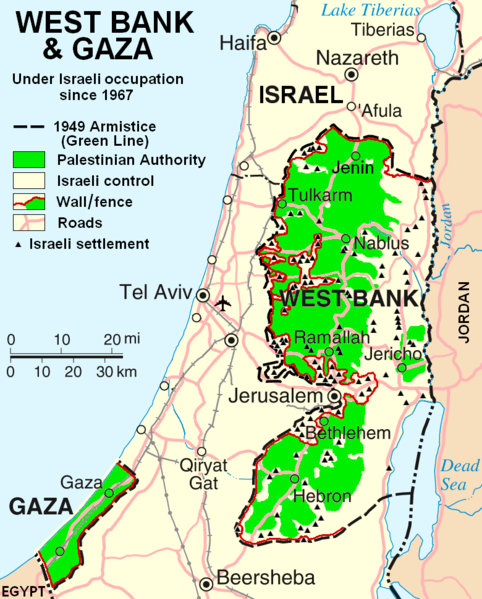
This map is a modification, suggested as a replacement for, or in addition to, the one uploaded by ChrisO at

    http://en.wikipedia.org/wiki/Image:Israel_and_occupied_territories_map.png

which is used in the Wikipedia article "Palestine," under the History subheading Current Status.

My modification shows "facts on the ground" which are essential to any understanding of the situation in Palestine today. The geographic facts are not in dispute. They have been widely published in print and on the internet.

Both my map and the ChrisO map are modifications of a 2004 United Nations map of Israel:

     http://www.un.org/Depts/Cartographic/map/profile/israel.pdf

(public domain) in which the three Occupied Territories, the West Bank, Gaza, and Golon, are given the same brown color as Israel's neighboring countries: Egypt, Jordan, Syria, and Lebanon. ChrisO colors the West Bank, Gaza, and Golon light green and renames the map "Israel and the Occupied Territories." However Golon is Syrian, not Palestinian. For an article on Palestine, attention should be on the West Bank and Gaza.

My modification crops out Golon and the Negev desert to focus in on the West Bank and Gaza. It also incorporates information from several published sources to show the land and resources actually available to Palestinian people in these two territories, the West Bank in particular.

The main source of information on barriers and land distribution comes from a map by the United Nations Office for the Coordination of Humanitarian Affairs:

    http://www.ochaopt.org/documents/OCHAoPt_ClsrMp_WB0106_En.pdf

supplemented by two more United Nations maps:

    http://www.ochaopt.org/documents/WB_Barrier_Projections_July06.pdf
    http://www.ochaopt.org/documents/WB_Closure_Access_revised_CAP_June06.pdf

Two Israeli organizations have published similar maps:

    http://www.btselem.org/Download/Separation_Barrier_Map_Eng.pdf
    http://www.icahd.org/eng/images/articles/the-matrix-of-control.gif

And finally, the Washington Post published all this information on a full-page newspaper map here.

Each of these maps is much too detailed to illustrate a Wikipedia article. My modification simplifies the information for use on a map similar in scale to the other maps in the article on Palestine.

A similar map without the Israeli settlements is posted here

The word Palestine has been removed from the title of this map to satisfy criticism that the former title implied a Palestinian sovereignty over the West Bank and Gaza.

HowardMorland

Llicencia

Public domain Yo, el titular de los drechos d'autor d'esta obra, la llibero como dominiu públicu. Esto s'aplica nel mundu ensembre.
En dellos países seique esto nun seya posible llegalmente; nesti casu:
Doi a cualesquier persona permisu pa usar esta obra pa cualesquier propósitu, ensin denguna condición, menos si eses condiciones requierense pola llei.

derivative works

Obras derivadas de ésta:  Wbgz.svg

Pies

Añade una explicación corta acerca de lo que representa este archivo
Israel Palestine Map

Elementos representados en este archivo

representa a

Historial del ficheru

Calca nuna fecha/hora pa ver el ficheru como taba daquella.

Data/HoraMiniaturaDimensionesUsuariuComentariu
actual22:55 29 och 2013Miniatura de la versión a fecha de 22:55 29 och 2013780 × 970 (86 kB)ScottCorrect capitalization in legend.
22:54 29 och 2013Miniatura de la versión a fecha de 22:54 29 och 2013780 × 970 (86 kB)ScottCorrect capitalization in legend.
06:21 12 xin 2009Miniatura de la versión a fecha de 06:21 12 xin 2009780 × 970 (105 kB)HowardMorlandReplace .gif file with identical .png file <!--{{ImageUpload|basic}}-->

Les páxines siguientes usen esti ficheru:

Usu global del ficheru

Estes otres wikis usen esti ficheru:

Ver más usos globales d'esti ficheru.

Metadatos