
Ficheru:Viking Expansion-es.svg

Tamañu de la vista previa PNG d'esti ficheru SVG: 793 × 521 pixels. Otres resoluciones: 320 × 210 pixels | 640 × 420 pixels | 1024 × 673 pixels | 1280 × 841 pixels | 2560 × 1682 pixels.
Ficheru orixinal (ficheru SVG, 793 × 521 píxels nominales, tamañu de ficheru: 1,33 MB)
Resume
| Descripción |
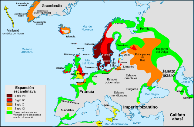
Português: Mapa da expansão viquingue Español: Mapa de la expansión vikinga. |
| Data | |
| Fonte |
Este archivo deriva de: Viking Expansion-pt.svg : Max Naylor |
| Autor |
|
| Otres versiones |
[]
|


Llicencia
Yo, el titular de los drechos d'autor d'esta obra, la espublizo baxo la siguiente llicencia:
Esti ficheru ta disponible baxo la llicencia Creative Commons Reconocimientu-Compartir igual 3.0 xenérica.
- Ye llibre:
- pa compartir – pa copiar, distribuir y comunicar públicamente la obra
- pa remezclar – p'adautar la obra
- Baxo les condiciones siguientes:
- reconocimientu – Tienes de dar el créitu apropiáu, apurrir un enllaz a la llicencia ya indicar si realizasti dalgún cambéu. Puedes faelo de cualquier mou razonable ,pero non de manera que suxera l'encontu del autor pa ti o pal usu que faigas.
- compartir igual – Si entemeces, tresformes o te bases nesti material, tienes de distribuir les tos contribuciones baxo la mesma llicencia o una compatible cola orixinal.
Historial del ficheru
Calca nuna fecha/hora pa ver el ficheru como taba daquella.
| Data/Hora | Miniatura | Dimensiones | Usuariu | Comentariu | |
|---|---|---|---|---|---|
| actual | 15:46 26 feb 2018 | | 793 × 521 (1,33 MB) | Asmodim | Added the areas of the Norman "Kingdom of Africa" (see article on english wikipedia), conquest part of the Norman kingdom of Sicily under Roger II. |
| 09:55 7 xin 2017 |  | 793 × 521 (1,32 MB) | Rowanwindwhistler | https://en.wikipedia.org/wiki/Wikipedia:WikiProject_Maps/Conventions Fake text added | |
| 17:55 15 xnt 2014 |  | 793 × 521 (738 kB) | Rowanwindwhistler | User created page with UploadWizard |
Usu del ficheru
La páxina siguiente usa esti ficheru:
Usu global del ficheru
Estes otres wikis usen esti ficheru:
- Usu en es.wikipedia.org
- Usu en es.wikibooks.org
- Usu en eu.wikipedia.org