
Ficheru:US insular areas.png

Ficheru orixinal (1482 × 624 píxels, tamañu de ficheru: 39 kB, triba MIME: image/png)

|
File:US insular areas.svg es una versión vectorial de este archivo. Debería usarse esa versión en lugar de este archivo PNG, cuando sea mejor.
File:US insular areas.png → File:US insular areas.svg
Para más información, lee Ayuda:SVG. |
 |
Resume
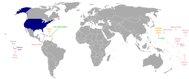
This is a map of the US Insular areas. The first version of this map was based off Image:BlankMap-World-v6.png by User:Astrokey44 with the locations of a few islands added; the source for this are two CIA maps; the maps are a map of the Pacific region and a map of the United States Pacific Island Wildlife Refuges. Hawaii has also been added to the map. Names of the islands are from the CIA Factbook. The second version is based off Image:Dependent_territories_2007.png by User:Sesmith. This map is color-coded according to each island's status:
For an uncolor-coded map, see Image:US_insular_areas-B.png. For a version with the freely associated states, see Image:US_insular_areas FAS.png.
The previous map is under the GFDL; because of this, this map is also.
Llicencia

|
Autorízase la copia, distribución y/o cambéu d'esti documentu baxo los términos de la Llicencia de documentación llibre GNU, versión 1.2 o cualesquier otra que nel futuru espublice la Free Software Foundation; ensin seiciones invariables, testos de portada, nin testos de contraportada. S'inclúi una copia de la llicencia na seición titulada GNU Free Documentation License. |
| Esti ficheru ta disponible baxo la llicencia Creative Commons Reconocimientu-Compartir igual 3.0 xenérica. | ||
| ||
| Esta etiqueta de llicencia s'amestó a esti ficheru como parte del anovamientu de la llicencia GFDL. |
Historial del ficheru
Calca nuna fecha/hora pa ver el ficheru como taba daquella.
| Data/Hora | Miniatura | Dimensiones | Usuariu | Comentariu | |
|---|---|---|---|---|---|
| actual | 06:35 2 ago 2014 | | 1482 × 624 (39 kB) | KronosLine | Fix Ukraine, the Caucasus, and added South Sudan. |
| 04:52 5 mar 2008 |  | 1482 × 624 (52 kB) | Hoshie | rebuilt using User:Sesmith's maps; more to come. | |
| 10:38 17 mar 2007 |  | 1482 × 624 (32 kB) | Hoshie | This is a map of the US Insular areas. The base map is Image:BlankMap-World-v6.png by User:Astrokey44 with the locations of a few islands added; the source for this are two CIA maps; the maps are a [https://www.cia.gov/cia/publications/factbook/ |
Usu del ficheru
La páxina siguiente usa esti ficheru:
Usu global del ficheru
Estes otres wikis usen esti ficheru:
- Usu en es.wikipedia.org
- Usu en vi.wikipedia.org
- Usu en www.wikidata.org