
Ficheru:US Virgin Islands admin divisions.png
Tamañu d'esta previsualización: 800 × 486 pixels. Otres resoluciones: 320 × 194 pixels | 640 × 389 pixels | 1022 × 621 pixels.
Ficheru orixinal (1022 × 621 píxels, tamañu de ficheru: 33 kB, triba MIME: image/png)

|
This map has been uploaded by Electionworld from en.wikipedia.org to enable the |
Resume
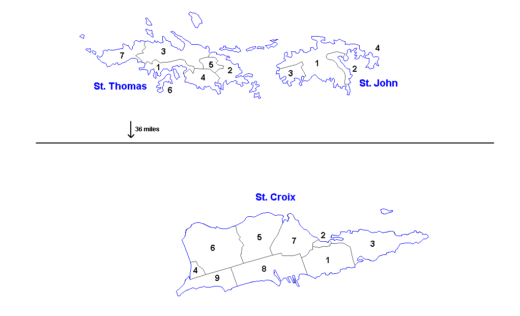
Administrative divisions of the U.S. Virgin Islands. Created by Rarelibra 16:11, 31 March 2006 (UTC) for public domain use. Created using MapInfo Professional v7.5 and vairous mapping resources.
| Districts | Saint Thomas | Saint John | Saint Croix |
|---|---|---|---|
| Sub-districts |
|
|
|
Llicencia
| Yo, el titular de los drechos d'autor d'esta obra, la llibero como dominiu públicu. Esto s'aplica nel mundu ensembre. En dellos países seique esto nun seya posible llegalmente; nesti casu: Doi a cualesquier persona permisu pa usar esta obra pa cualesquier propósitu, ensin denguna condición, menos si eses condiciones requierense pola llei. |
Historial del ficheru
Calca nuna fecha/hora pa ver el ficheru como taba daquella.
| Data/Hora | Miniatura | Dimensiones | Usuariu | Comentariu | |
|---|---|---|---|---|---|
| actual | 13:57 19 mar 2014 | | 1022 × 621 (33 kB) | Ahnoneemoos | removing border |
| 13:55 19 mar 2014 |  | 1022 × 621 (33 kB) | Ahnoneemoos | removing border | |
| 20:31 27 pay 2006 |  | 1025 × 624 (15 kB) | Electionworld | {{ew|en|Rarelibra}} == Summary == Administrative divisions (districts and sub-districts) of the U.S. Virgin Islands. Created by Rarelibra 16:11, 31 March 2006 (UTC) for public domain use. Created using MapInfo Professional v7.5 and |
Usu del ficheru
La páxina siguiente usa esti ficheru:
Usu global del ficheru
Estes otres wikis usen esti ficheru:
- Usu en en.wikipedia.org
- Usu en eu.wikipedia.org
- Usu en gl.wikipedia.org
- Usu en li.wikipedia.org
- Usu en mk.wikipedia.org
- Usu en ml.wikipedia.org
- Usu en nn.wikipedia.org
- Usu en no.wikipedia.org
- Usu en os.wikipedia.org
- Usu en sr.wikipedia.org
- Usu en ta.wikipedia.org
- Usu en uk.wikipedia.org
- Usu en vi.wikipedia.org
- Usu en www.wikidata.org