
Ficheru:Tonga location map.svg

Tamañu de la vista previa PNG d'esti ficheru SVG: 231 × 598 pixels. Otres resoluciones: 92 × 240 pixels | 185 × 480 pixels | 296 × 768 pixels | 395 × 1024 pixels | 791 × 2048 pixels | 677 × 1753 pixels.
Ficheru orixinal (ficheru SVG, 677 × 1753 píxels nominales, tamañu de ficheru: 77 kB)
Resume
| Posición de la cámara | | Ubicación de esta y otras imágenes en: OpenStreetMap |
|---|
| Descripción |
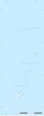
English: Blank administrative map of Tonga, for geo-location purposes.
Français : Carte administrative vierge de la Tonga, destinée à la géolocalisation. Scale: 1:3,720,000 (precision: 930 m)
Geographic limits of the map:
|
||
| Data | |||
| Fonte |
Trabayu propiu
|
||
| Autor | Eric Gaba (Sting - fr:Sting) | ||
| Permisu (Cómo reutilizar esti ficheru) |
|
||
| Otres versiones |
|
Llicencia
Yo, el titular de los drechos d'autor d'esta obra, la espublizo baxo les siguientes llicencies:
Esti ficheru ta disponible baxo la llicencia Creative Commons Reconocimientu-Compartir igual 3.0 xenérica.
- Ye llibre:
- pa compartir – pa copiar, distribuir y comunicar públicamente la obra
- pa remezclar – p'adautar la obra
- Baxo les condiciones siguientes:
- reconocimientu – Tienes de dar el créitu apropiáu, apurrir un enllaz a la llicencia ya indicar si realizasti dalgún cambéu. Puedes faelo de cualquier mou razonable ,pero non de manera que suxera l'encontu del autor pa ti o pal usu que faigas.
- compartir igual – Si entemeces, tresformes o te bases nesti material, tienes de distribuir les tos contribuciones baxo la mesma llicencia o una compatible cola orixinal.

|
Autorízase la copia, distribución y/o cambéu d'esti documentu baxo los términos de la Llicencia de documentación llibre GNU, versión 1.2 o cualesquier otra que nel futuru espublice la Free Software Foundation; ensin seiciones invariables, testos de portada, nin testos de contraportada. S'inclúi una copia de la llicencia na seición titulada GNU Free Documentation License. |
Pues seleicionar la llicencia que prefieras.
Historial del ficheru
Calca nuna fecha/hora pa ver el ficheru como taba daquella.
| Data/Hora | Miniatura | Dimensiones | Usuariu | Comentariu | |
|---|---|---|---|---|---|
| actual | 19:16 1 avi 2009 | 677 × 1753 (77 kB) | Sting | == {{int:filedesc}} == {{Location|18|57|00|S|174|57|00|W|scale:5000000}} <br/> {{Information |Description={{en|Blank administrative map of Tonga, for geo-location purposes.}} {{fr|Carte administrative vierge de la Tonga, destin |
Usu del ficheru
Les páxines siguientes usen esti ficheru:
Usu global del ficheru
Estes otres wikis usen esti ficheru:
- Usu en af.wikipedia.org
- Usu en als.wikipedia.org
- Usu en an.wikipedia.org
- Usu en ar.wikipedia.org
- Usu en az.wikipedia.org
- Usu en be-tarask.wikipedia.org
- Usu en be.wikipedia.org
- Usu en bg.wikipedia.org
- Usu en bn.wikipedia.org
- Usu en bs.wikipedia.org
- Usu en ca.wikipedia.org
- Usu en ceb.wikipedia.org
- Plantilya:Location map Tonga
- The Narrows
- Fata
- Sandy Point
- East Point
- Mango (pagklaro)
- Puhi
- Lolo (pagklaro)
- Fua
- Uia
- Lima (pagklaro)
- Ward Rock
- Barrier Reef
- Eastern Passage
- Mango Island
- Buhi
- Amsterdam Island
- Middelburg
- Tafuna
- Ofu Island
- Mount Zion
- North Passage
- Herald Bight
- Big Lake
- Bickerton Island
- Home Reef
- Falcon Island
- Alexander Reef
- Ava
- Port Refuge
- Boloa
- Kaba
- Ngau
- Tauga
- Labe
Ver más usos globales d'esti ficheru.