
Ficheru:Sevastopol, Ukraine.jpg

Ficheru orixinal (1080 × 1440 píxels, tamañu de ficheru: 455 kB, triba MIME: image/jpeg)
Resume
| Descripción |
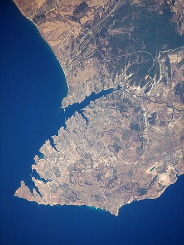
English: This satellite image highlights the jagged coastline of the southern Crimean Peninsula and the various docking areas of Sevastopol. The urban area is light grey, and it is bounded to the north and west by the Black Sea, to the south by vegetated (light green) and fallow (tan) agricultural fields, and to the east by the city of Inkerman and vegetated uplands (deep green). The city of Balaklava, to the south, houses another relic of the Cold War—an underground Soviet submarine base that is now open to the public as a monument. The Chernaya River issues into the Black Sea near Inkerman, flowing into the Sevastopol Inlet to the west.
|
||||||||||||||||||||||||||||||||||||||||||||||||||||||
| Data | |||||||||||||||||||||||||||||||||||||||||||||||||||||||
| Fonte | NASA Earth Observatory | ||||||||||||||||||||||||||||||||||||||||||||||||||||||
| Autor | This image was taken by the Nasa Expedition 20 crew. | ||||||||||||||||||||||||||||||||||||||||||||||||||||||
Image acquired with a Nikon D3 digital camera fitted with a 400 mm lens, and is provided by the ISS Crew Earth Observations experiment and Image Science & Analysis Laboratory, Johnson Space Centre. Instrument: ISS - Digital Camera.
Llicencia
| Este archivo es de dominio público porque fue creado por la NASA. Las políticas sobre copyright de la NASA estipulan que «el material de la NASA no está protegido con copyright a menos que se indique lo contrario». (Políticas sobre copyright de la NASA o Políticas sobre la utilización de imágenes del Jet Propulsion Laboratory). | ||
 |
Advertencias:
|
| Annotations | This image is annotated: View the annotations at Commons |
Historial del ficheru
Calca nuna fecha/hora pa ver el ficheru como taba daquella.
| Data/Hora | Miniatura | Dimensiones | Usuariu | Comentariu | |
|---|---|---|---|---|---|
| actual | 11:44 20 xin 2015 | | 1080 × 1440 (455 kB) | Anonimski | Rotated to proper map orientation |
| 09:27 24 ago 2009 |  | 1440 × 1080 (532 kB) | Originalwana | {{Information |Description={{en|1=This astronaut photograph highlights the jagged coastline of the southern Crimean Peninsula and the various docking areas of Sevastopol. The urban area is light grey, and it is bounded to the north and west by the Black S |
Usu del ficheru
La páxina siguiente usa esti ficheru:
Usu global del ficheru
Estes otres wikis usen esti ficheru:
- Usu en af.wikipedia.org
- Usu en azb.wikipedia.org
- Usu en az.wikipedia.org
- Usu en bn.wikipedia.org
- Usu en ca.wikipedia.org
- Usu en de.wikipedia.org
- Usu en de.wikivoyage.org
- Usu en en.wikipedia.org
- Usu en es.wikipedia.org
- Usu en fa.wikipedia.org
- Usu en is.wikipedia.org
- Usu en it.wikipedia.org
- Usu en mn.wikipedia.org
- Usu en pl.wikipedia.org
- Usu en pl.wiktionary.org
- Usu en ru.wikipedia.org
- Usu en uk.wikipedia.org
- Usu en uk.wikivoyage.org
- Usu en www.wikidata.org
- Usu en zh.wikipedia.org