
Ficheru:SerbiaEn1913.svg

Tamañu de la vista previa PNG d'esti ficheru SVG: 443 × 600 pixels. Otres resoluciones: 177 × 240 pixels | 354 × 480 pixels | 567 × 768 pixels | 756 × 1024 pixels | 1513 × 2048 pixels | 492 × 666 pixels.
Ficheru orixinal (ficheru SVG, 492 × 666 píxels nominales, tamañu de ficheru: 1,4 MB)
| Descripción |
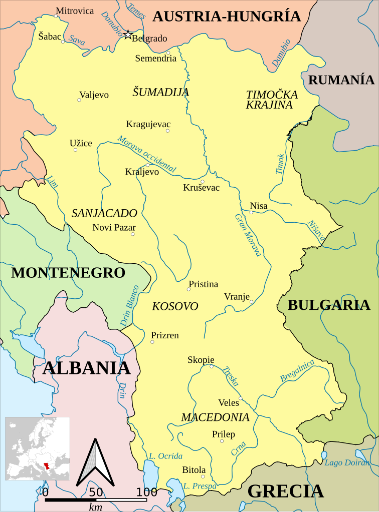
Español: Fronteras de Serbia en 1913, tras la Segunda Guerra Balcánica.
English: Serbia in 1913, after the territorial gains of the Second Balkan War.
Català: Sèrbia el 1913, després dels guanys territorials de la Segona Guerra Balcànica. |
| Data | (UTC) |
| Fonte | |
| Autor |
|
| Esta ye una imaxe retocada, lo que significa que foi modificada dixitalmente de la so versión orixinal. Modificaciones: Turned into SVG and translated into Spanish. La orixinal pue vese equí: Serbia1913.png:
|
Esti ficheru ta disponible baxo la llicencia Creative Commons Reconocimientu-Compartir igual 3.0 xenérica.
- Ye llibre:
- pa compartir – pa copiar, distribuir y comunicar públicamente la obra
- pa remezclar – p'adautar la obra
- Baxo les condiciones siguientes:
- reconocimientu – Tienes de dar el créitu apropiáu, apurrir un enllaz a la llicencia ya indicar si realizasti dalgún cambéu. Puedes faelo de cualquier mou razonable ,pero non de manera que suxera l'encontu del autor pa ti o pal usu que faigas.
- compartir igual – Si entemeces, tresformes o te bases nesti material, tienes de distribuir les tos contribuciones baxo la mesma llicencia o una compatible cola orixinal.
Rexistru de xubíes orixinal
This image is a derivative work of the following images:
- File:Serbia1913.png licensed with PD-user
- 2010-01-18T00:09:19Z Bidgee 659x910 (58762 Bytes) I'll allow the new version
- 2010-01-18T00:03:07Z Bidgee 582x831 (18205 Bytes) Reverted to version as of 21:38, 21 December 2006 While the image does expand on the original please do not upload over it, upload the improved map under a new name.
- 2010-01-16T20:30:30Z PANONIAN 659x910 (58762 Bytes) improved version
- 2006-12-21T21:38:44Z Electionworld 582x831 (18205 Bytes) {{ew|en|PANONIAN}} Self-made map by [[user:PANONIAN|PANONIAN]] {{PD-user|PANONIAN}} [[Category:Maps of Serbia]]
Uploaded with derivativeFX
Historial del ficheru
Calca nuna fecha/hora pa ver el ficheru como taba daquella.
| Data/Hora | Miniatura | Dimensiones | Usuariu | Comentariu | |
|---|---|---|---|---|---|
| actual | 11:04 7 feb 2021 | | 492 × 666 (1,4 MB) | Rowanwindwhistler | New version. EPSG3857 Projection. Rivers, sea & main borders from Natural Earth. Town locations from Openstreetmap. Main border corrections from: Map of Bulgaria after Treaty of Neuilly-sur-Seinе-bg.svg (Ikonact) Montenegro territory expanded (1830-1944).png (Пакко) Corrections may be needed for the Albanian-Serbian border (being defined at the time) and the Austro-Romanian one. |
| 22:28 7 avi 2019 |  | 683 × 925 (251 kB) | Rowanwindwhistler | Corrected | |
| 22:17 7 avi 2019 |  | 683 × 925 (476 kB) | Rowanwindwhistler | Slight changes | |
| 13:46 27 xnt 2019 |  | 683 × 925 (247 kB) | Joutbis | File uploaded using svgtranslate tool (http://tools.wmflabs.org/svgtranslate/). Added translation for ca. | |
| 09:11 23 abr 2017 |  | 683 × 925 (232 kB) | Rowanwindwhistler | Fake text added | |
| 09:46 30 abr 2016 |  | 641 × 867 (79 kB) | Rowanwindwhistler | https://en.wikipedia.org/wiki/Wikipedia:WikiProject_Maps/Conventions | |
| 22:00 9 set 2010 |  | 641 × 867 (81 kB) | Rowanwindwhistler | {{Information |Description={{es|1=Fronteras de Serbia en 1913, tras la Segunda Guerra Balcánica.}} {{en|1=Serbia in 1913, after the territorial gains of the Second Balkan War.}} |Source=*File:Serbia1913.png |Date=2010-09-09 22:00 (UTC) |Author=*[[: |
Usu del ficheru
La páxina siguiente usa esti ficheru:
Usu global del ficheru
Estes otres wikis usen esti ficheru:
- Usu en ca.wikipedia.org
- Usu en de.wikipedia.org
- Usu en es.wikipedia.org
- Usu en mt.wikipedia.org