
Ficheru:ScotlandEastLothian.png
Nun ta disponible con mayor resolución.
ScotlandEastLothian.png (200 × 230 píxels, tamañu de ficheru: 4 kB, triba MIME: image/png)
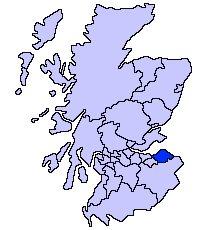
East Lothian unitary council
Slightly edited version of a map drawn by Morwen

|
Autorízase la copia, distribución y/o cambéu d'esti documentu baxo los términos de la Llicencia de documentación llibre GNU, versión 1.2 o cualesquier otra que nel futuru espublice la Free Software Foundation; ensin seiciones invariables, testos de portada, nin testos de contraportada. S'inclúi una copia de la llicencia na seición titulada GNU Free Documentation License. |
| Esti ficheru ta disponible baxo la llicencia Creative Commons Reconocimientu-Compartir igual 3.0 xenérica. | ||
| ||
| Esta etiqueta de llicencia s'amestó a esti ficheru como parte del anovamientu de la llicencia GFDL. |
Historial del ficheru
Calca nuna fecha/hora pa ver el ficheru como taba daquella.
| Data/Hora | Miniatura | Dimensiones | Usuariu | Comentariu | |
|---|---|---|---|---|---|
| actual | 21:33 17 may 2005 | | 200 × 230 (4 kB) | Voyager | East Lothian unitary council Slightly edited version of a map drawn by Morwen {{GFDL}} Category:Maps of Scottish unitary councils |
Usu del ficheru
La páxina siguiente usa esti ficheru:
Usu global del ficheru
Estes otres wikis usen esti ficheru:
- Usu en ar.wikipedia.org
- Usu en be.wikipedia.org
- Usu en bg.wikipedia.org
- Usu en ca.wikipedia.org
- Usu en cy.wikipedia.org
- Usu en da.wikipedia.org
- Usu en de.wikipedia.org
- Usu en en.wikipedia.org
- Usu en eu.wikipedia.org
- Ekialdeko Lothian
- Lankide:Euskaldunaa
- Haddington (Eskozia)
- Musselburgh
- Dunbar
- Txantiloi:Ekialdeko Lothian
- Aberlady
- Athelstaneford
- Auldhame eta Scoughall
- Bolton (Ekialdeko Lothian)
- Cockenzie eta Port Seton
- Dirleton
- Drem
- East Linton
- Whitekirk eta Tyninghame
- Wallyford
- East Saltoun eta West Saltoun
- Gifford (Ekialdeko Lothian)
- Gullane
- Wikiproiektu:Irlanda, Gales eta Eskoziako udalerriak
- Ballencrieff (Ekialdeko Lothian)
- North Berwick
- Prestonpans
- Tranent
- Bara (Ekialdeko Lothian)
- Belhaven (Eskozia)
- Biel (Ekialdeko Lothian)
- Bilsdean
- Broxburn (Ekialdeko Lothian)
- Canty Bay
- Carberry (Ekialdeko Lothian)
- Dunglass
- East Fortune
- Elphinstone (Ekialdeko Lothian)
- Garvald (Ekialdeko Lothian)
- Gladsmuir
- Humbie
- Innerwick
- Inveresk
- Kingston (Ekialdeko Lothian)
Ver más usos globales d'esti ficheru.