
Ficheru:Saxony locator map (1000).svg

Tamañu de la vista previa PNG d'esti ficheru SVG: 686 × 600 pixels. Otres resoluciones: 275 × 240 pixels | 549 × 480 pixels | 878 × 768 pixels | 1171 × 1024 pixels | 2342 × 2048 pixels | 4431 × 3875 pixels.
Ficheru orixinal (ficheru SVG, 4431 × 3875 píxels nominales, tamañu de ficheru: 4,7 MB)
Resume
| Descripción |
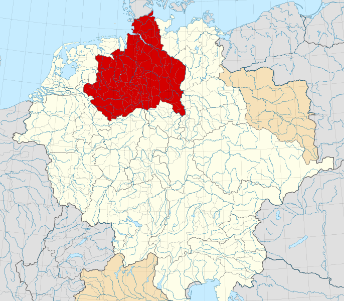
English: A map of the Duchy of Saxony (German: Herzogtum Sachsen) around 1000 CE.
The map is derived from a vectorised version of one found in Professor G. Droysens Allgemeiner Historischer Handatlas, which was published in 1886 by R. Andrée Plate, and is now in the public domain. Note that while it uses the same scheme as standard location/locator maps, this map technically does not conform to the standard, as it is not in equirectangular projection. Therefore grid lines for latitude and longitude are also included on the sub-map. |
| Data | |
| Fonte |
File: own work Data: File:Droysens-22-23.jpg |
| Autor | Alphathon /ˈæɫfə.θɒn/ (talk) |
| Otres versiones |
|
.svg)
.svg)
.svg)
.svg)

.svg)
.svg)
.svg)
Llicencia
Este archivo está disponible bajo la licencia Creative Commons Attribution-Share Alike 4.0 International.
- Ye llibre:
- pa compartir – pa copiar, distribuir y comunicar públicamente la obra
- pa remezclar – p'adautar la obra
- Baxo les condiciones siguientes:
- reconocimientu – Tienes de dar el créitu apropiáu, apurrir un enllaz a la llicencia ya indicar si realizasti dalgún cambéu. Puedes faelo de cualquier mou razonable ,pero non de manera que suxera l'encontu del autor pa ti o pal usu que faigas.
- compartir igual – Si entemeces, tresformes o te bases nesti material, tienes de distribuir les tos contribuciones baxo la mesma llicencia o una compatible cola orixinal.
Historial del ficheru
Calca nuna fecha/hora pa ver el ficheru como taba daquella.
| Data/Hora | Miniatura | Dimensiones | Usuariu | Comentariu | |
|---|---|---|---|---|---|
| actual | 16:15 22 may 2016 | | 4431 × 3875 (4,7 MB) | Alphathon | Changed colour of the Kingdom of Italy to reflect its inclusion in the Holy Roman Empire. Changed the colour of Silesian tributaries so as the not imply it was part of the Kingdom. Also changed colour of Rügen since it was neither in the Empire nor th... |
| 02:26 18 may 2016 |  | 4431 × 3875 (4,7 MB) | Alphathon | == {{int:filedesc}} == {{Inkscape}} {{Information |Description={{en|A map of the en:Duchy of Saxony (German: ''Herzogtum Sachsen'') around 1000 CE. The map is derived from a vectorised version of one found in Professor G. Droysens Allgem... |
Usu del ficheru
La páxina siguiente usa esti ficheru:
Usu global del ficheru
Estes otres wikis usen esti ficheru:
- Usu en ar.wikipedia.org
- Usu en azb.wikipedia.org
- Usu en be.wikipedia.org
- Usu en bg.wikipedia.org
- Usu en ca.wikipedia.org
- Usu en cs.wikipedia.org
- Usu en de.wikipedia.org
- Usu en el.wikipedia.org
- Usu en en.wikipedia.org
- Usu en es.wikipedia.org
- Usu en et.wikipedia.org
- Usu en fa.wikipedia.org
- Usu en fr.wikipedia.org
- Usu en fy.wikipedia.org
- Usu en ga.wikipedia.org
- Usu en it.wikipedia.org
- Usu en ja.wikipedia.org
- Usu en ko.wikipedia.org
- Usu en mk.wikipedia.org
- Usu en pl.wikipedia.org
- Usu en pl.wiktionary.org
- Usu en th.wikipedia.org
- Usu en tr.wikipedia.org
- Usu en vi.wikipedia.org
- Usu en www.wikidata.org
- Usu en zh.wikipedia.org
.svg)