
Ficheru:RomaniaBorderHistoryAnnimation 1859-2010.gif
Tamañu d'esta previsualización: 696 × 599 pixels. Otres resoluciones: 279 × 240 pixels | 558 × 480 pixels | 1000 × 861 pixels.
Ficheru orixinal (1000 × 861 píxels, tamañu de ficheru: 162 kB, triba MIME: image/gif, animáu, 12 cuadros, 36s)
Resume
| Descripción |
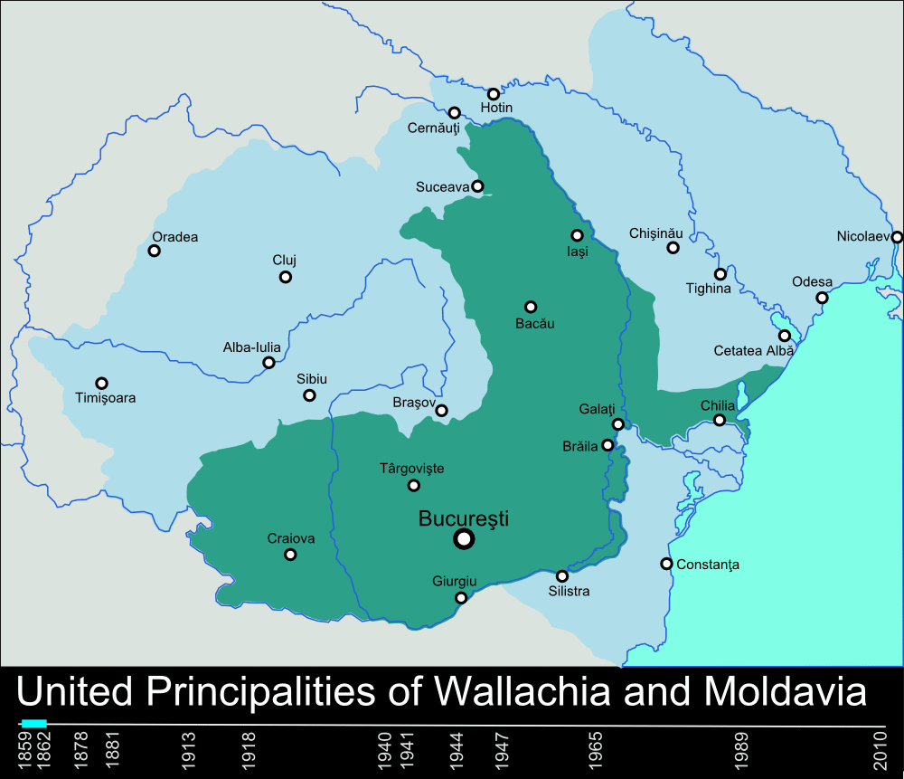
English: Timeline of the borders of Romania between 1859 and 2010. |
| Data | 11 de xineru de 2010 (fecha original de carga) |
| Fonte | self-made, individual frames were based on maps from here: Atlas of Romania. (I could upload standalone maps for each period of time, if needed. Contact me for that.). |
| Autor | User:Scooter20 |
| Otres versiones | Derivative works of this file: RomaniaBorderHistoryAnnimation 1859-2010 es.gif |
Llicencia
| L'autor d'esta obra, Scooter20 de Wikipedia en inglés, la lliberó como dominiu públicu. Esto s'aplica nel mundu ensembre. En dellos países seique esto nun seya posible llegalmente; nesti casu: Scooter20 da a cualesquier persona permisu pa usar esta obra pa cualesquier propósitu, ensin denguna condición, menos si eses condiciones requierense pola llei. |
Rexistru de xubíes orixinal
Transferred from en.wikipedia to Commons by Rowanwindwhistler using CommonsHelper.
The original description page was here. All following user names refer to en.wikipedia.
- 2010-01-11 22:17 Scooter20 1000×861× (166899 bytes) Reverted to version as of 12:48, 31 December 2009
- 2010-01-10 21:53 Alexandrey 1000×861× (152174 bytes) Reverted to version as of 19:31, 30 December 2009
- 2010-01-10 21:52 Alexandrey 1000×861× (166932 bytes) Reverted to version as of 12:29, 31 December 2009
- 2009-12-31 12:48 Scooter20 1000×861× (166899 bytes) fixed Hertza region, which didn't belong to Romania after 1944
- 2009-12-31 12:29 Scooter20 1000×861× (166932 bytes) Added new intervals: 1862-1878, 1878-1881 - United Romanian Principalities 1947-1965 - People's Republic of Romania
- 2009-12-31 00:57 Scooter20 1000×861× (153234 bytes) fixed location of the city of Sibiu
- 2009-12-30 19:31 Scooter20 1000×861× (152174 bytes) Timeline of the borders of Romania between 1859 and 2010.
Historial del ficheru
Calca nuna fecha/hora pa ver el ficheru como taba daquella.
| Data/Hora | Miniatura | Dimensiones | Usuariu | Comentariu | |
|---|---|---|---|---|---|
| actual | 22:02 9 mar 2012 | | 1000 × 861 (162 kB) | Scooter20 | Better colors! |
| 16:07 8 set 2010 |  | 1000 × 861 (168 kB) | Mihai Andrei | Corrected the name of the city of Cluj for the period until 1975. | |
| 00:09 4 set 2010 |  | 1000 × 861 (163 kB) | Anonimizat XXX | (I tried to revert to the version from april 2010 but it didn't work, so I've decided to manually upload again) | |
| 00:02 4 set 2010 |  | 1000 × 861 (163 kB) | Anonimizat XXX | Reverted to version as of 20:45, 21 April 2010 (animation broken, also, the name of Cluj is actually Cluj-Napoca as the original gif indicate) | |
| 18:02 9 ago 2010 |  | 1000 × 861 (73 kB) | Mihai Andrei | Corrected the name of the city of Cluj. | |
| 20:45 21 abr 2010 |  | 1000 × 861 (163 kB) | File Upload Bot (Magnus Manske) | {{BotMoveToCommons|en.wikipedia|year={{subst:CURRENTYEAR}}|month={{subst:CURRENTMONTHNAME}}|day={{subst:CURRENTDAY}}}} {{Information |Description={{en|Timeline of the borders of Romania between 1859 and 2010.<br/> == Other versions == [[:en:Image:Flag_of |
Usu del ficheru
La páxina siguiente usa esti ficheru:
Usu global del ficheru
Estes otres wikis usen esti ficheru:
- Usu en af.wikipedia.org
- Usu en ar.wikipedia.org
- Usu en ary.wikipedia.org
- Usu en azb.wikipedia.org
- Usu en bcl.wikipedia.org
- Usu en da.wikipedia.org
- Usu en de.wikipedia.org
- Usu en el.wikipedia.org
- Usu en en.wikipedia.org
- Romania
- History of Romania
- Former administrative divisions of Romania
- Kingdom of Romania
- Romanians
- Administrative divisions of Romania
- Portal:Romania
- User:Scooter20
- Union of Transylvania with Romania
- User:Iadrian yu
- User talk:Iadrian yu/Archive April,2010
- Territorial evolution of Romania
- 2010 in Romania
- Usu en et.wikipedia.org
- Usu en eu.wikipedia.org
- Usu en fa.wikipedia.org
- Usu en fi.wikipedia.org
- Usu en it.wikipedia.org
- Usu en ja.wikipedia.org
- Usu en ka.wikipedia.org
- Usu en lv.wikipedia.org
- Usu en mk.wikipedia.org
- Usu en no.wikipedia.org
- Usu en pt.wikipedia.org
- Usu en ro.wikibooks.org
- Usu en ru.wikipedia.org
- Usu en sl.wikipedia.org
Ver más usos globales d'esti ficheru.