
Ficheru:Rogaland Municipalities.png
Tamañu d'esta previsualización: 800 × 487 pixels. Otres resoluciones: 320 × 195 pixels | 640 × 390 pixels | 1025 × 624 pixels.
Ficheru orixinal (1025 × 624 píxels, tamañu de ficheru: 22 kB, triba MIME: image/png)

|
File:Rogaland Municipalities.svg es una versión vectorial de este archivo. Debería usarse esa versión en lugar de este archivo PNG, cuando sea mejor.
File:Rogaland Municipalities.png → File:Rogaland Municipalities.svg
Para más información, lee Ayuda:SVG. |
 |
Transferred from en.wikipedia to Commons by Maksim.
The original description page was here. All following user names refer to en.wikipedia.
Resume
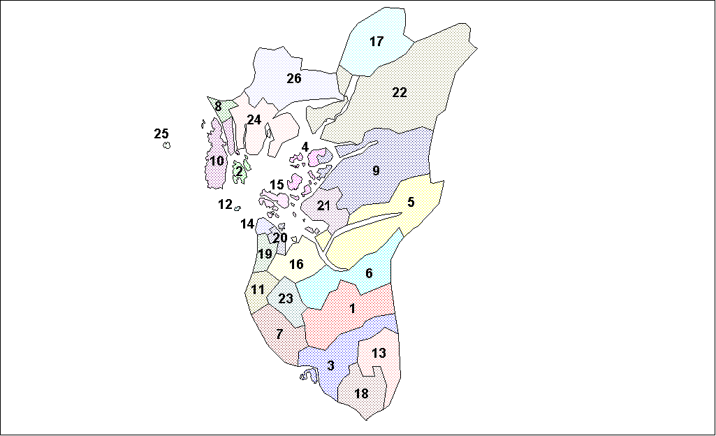
Map of the municipalities of Rogaland County in Norway. Created by Rarelibra for public domain use. Created using MapInfo Professional v7.5 and various mapping resources.
Llicencia
| Yo, el titular de los drechos d'autor d'esta obra, la llibero como dominiu públicu. Esto s'aplica nel mundu ensembre. En dellos países seique esto nun seya posible llegalmente; nesti casu: Doi a cualesquier persona permisu pa usar esta obra pa cualesquier propósitu, ensin denguna condición, menos si eses condiciones requierense pola llei. |
| date/time | username | edit summary |
|---|---|---|
| 18:05, 26 January 2006 | en:User:Rarelibra | (Map of the municipalities of Rogaland County in Norway. Created by <a href="/wiki/User:Rarelibra" title="User:Rarelibra">Rarelibra</a> for public domain use. Created using MapInfo Professional v7.5 and various mapping resources.) |
Rexistru de xubíes orixinal
Legend: (cur) = this is the current file, (del) = delete this old version, (rev) = revert to this old version.
Click on date to download the file or see the image uploaded on that date.
- (del) (cur) 18:13, 26 January 2006 . . en:User:Rarelibra Rarelibra ( en:User_talk:Rarelibra Talk) . . 1025x624 (22714 bytes) (Map of the municipalities of Rogaland County in Norway. Created by en:User:Rarelibra Rarelibra for public domain use. Created using MapInfo Professional v7.4 and various mapping resources.)
- (del) (rev) 18:05, 26 January 2006 . . en:User:Rarelibra Rarelibra ( en:User_talk:Rarelibra Talk) . . 1025x624 (22940 bytes) (Map of the municipalities of Rogaland County in Norway. Created by en:User:Rarelibra Rarelibra for public domain use. Created using MapInfo Professional v7.5 and various mapping resources.)
Historial del ficheru
Calca nuna fecha/hora pa ver el ficheru como taba daquella.
| Data/Hora | Miniatura | Dimensiones | Usuariu | Comentariu | |
|---|---|---|---|---|---|
| actual | 21:22 3 ago 2007 | | 1025 × 624 (22 kB) | Rarelibra | Map of the municipalities of Rogaland County in Norway. Created by Rarelibra for public domain use. Created using MapInfo Professional v7.5 and various mapping resources. |
| 12:50 28 xin 2006 |  | 1025 × 624 (22 kB) | Maksim | La bildo estas kopiita de wikipedia:en. La originala priskribo estas: == Summary == Map of the municipalities of Rogaland County in Norway. Created by Rarelibra for public domain use. Created using MapInfo Professional v7.5 and various |
Usu del ficheru
La páxina siguiente usa esti ficheru:
Usu global del ficheru
Estes otres wikis usen esti ficheru:
- Usu en azb.wikipedia.org
- Usu en bat-smg.wikipedia.org
- Usu en bcl.wikipedia.org
- Usu en ca.wikipedia.org
- Usu en da.wikipedia.org
- Usu en en.wikipedia.org
- Usu en eo.wikipedia.org
- Usu en et.wikipedia.org
- Usu en eu.wikipedia.org
- Usu en fo.wikipedia.org
- Usu en hu.wikipedia.org
- Usu en id.wikipedia.org
- Usu en ja.wikipedia.org
- Usu en ka.wikipedia.org
- Usu en ko.wikipedia.org
- Usu en lt.wikipedia.org
- Usu en pl.wikipedia.org
- Usu en ro.wikipedia.org
- Usu en ru.wikipedia.org
- Usu en sco.wikipedia.org
- Usu en so.wikipedia.org
- Usu en sr.wikipedia.org
- Usu en sw.wikipedia.org
- Usu en tr.wikipedia.org
- Usu en vi.wikipedia.org