
Ficheru:River Nith estuary.jpg

Tamañu d'esta previsualización: 800 × 533 pixels. Otres resoluciones: 320 × 213 pixels | 640 × 427 pixels | 1024 × 683 pixels | 1280 × 853 pixels | 2560 × 1707 pixels | 3504 × 2336 pixels.
Ficheru orixinal (3504 × 2336 píxels, tamañu de ficheru: 8,68 MB, triba MIME: image/jpeg)
Resume
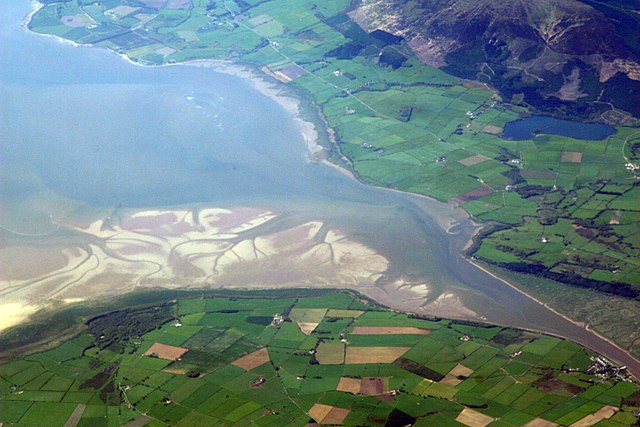
| Descripción | The estuary of the River Nith, Scotland, at low tide; opening into Solway Firth. This is a view of the Nith estuary from the north-east. The group of buildings at bottom right is the village of Glencaple. At bottom left near the wooded area is Caerlaverock Castle. At top right is Loch Kindar and the hill above is called Criffel. Just beyond the top left of photo is the birthplace of John Paul Jones. |
| Data | |
| Fonte | https://www.flickr.com/photos/52614599@N00/483602946 |
| Autor | Doc Searls from Santa Barbara, USA |
Llicencia
Este archivo se encuentra bajo la licencia Creative Commons Genérica de Atribución/Compartir-Igual 2.0.
- Ye llibre:
- pa compartir – pa copiar, distribuir y comunicar públicamente la obra
- pa remezclar – p'adautar la obra
- Baxo les condiciones siguientes:
- reconocimientu – Tienes de dar el créitu apropiáu, apurrir un enllaz a la llicencia ya indicar si realizasti dalgún cambéu. Puedes faelo de cualquier mou razonable ,pero non de manera que suxera l'encontu del autor pa ti o pal usu que faigas.
- compartir igual – Si entemeces, tresformes o te bases nesti material, tienes de distribuir les tos contribuciones baxo la mesma llicencia o una compatible cola orixinal.
| Esta imagen fue publicada en Flickr por dsearls en https://www.flickr.com/photos/52614599@N00/483602946. La imagen fue revisada el 5 de mayu de 2007 por el robot FlickreviewR y confirmó tener licencia bajo los términos de cc-by-sa-2.0. |
This is a view of the Nith estuary from the north-east. The group of buildings at bottom right is the village of Glencaple. At bottom left near the wooded area is Caerlaverock Castle. At top right is Loch Kindar and the hill above is called Criffel. Just beyond the top left of photo is the birthplace of John Paul Jones.
Historial del ficheru
Calca nuna fecha/hora pa ver el ficheru como taba daquella.
| Data/Hora | Miniatura | Dimensiones | Usuariu | Comentariu | |
|---|---|---|---|---|---|
| actual | 07:14 5 may 2007 | | 3504 × 2336 (8,68 MB) | Sandstein | {{Information |Description= The estuary of the River Nith, Scotland, at low tide; opening into Solway Firth. On the near shore, Bowness-on-Solway. On the far, Annan, in Dumfries and Galloway. |Source= http://www.flickr.com/photos/52614599@N00/483602946 |D |
Usu del ficheru
La páxina siguiente usa esti ficheru:
Usu global del ficheru
Estes otres wikis usen esti ficheru:
- Usu en ar.wikipedia.org
- Usu en arz.wikipedia.org
- Usu en bn.wikipedia.org
- Usu en br.wikipedia.org
- Usu en ceb.wikipedia.org
- Usu en cs.wikipedia.org
- Usu en cy.wikipedia.org
- Usu en dag.wikipedia.org
- Usu en de.wikipedia.org
- Usu en en.wikipedia.org
- Usu en en.wikivoyage.org
- Usu en eo.wikipedia.org
- Usu en es.wikipedia.org
- Usu en eu.wikipedia.org
- Usu en fa.wikipedia.org
- Usu en fr.wikipedia.org
- Usu en fy.wikipedia.org
- Usu en ga.wikipedia.org
- Usu en gd.wikipedia.org
- Usu en gv.wikipedia.org
- Usu en hak.wikipedia.org
- Usu en id.wikipedia.org
- Usu en incubator.wikimedia.org
- Usu en it.wikipedia.org
- Usu en it.wikibooks.org
- Usu en it.wikiversity.org
- Usu en ja.wikipedia.org
- Usu en kbd.wikipedia.org
- Usu en lt.wikipedia.org
- Usu en nl.wikipedia.org
Ver más usos globales d'esti ficheru.