
Ficheru:Ptolemaic-Empire 200bc.jpg
Ficheru orixinal (1164 × 636 píxels, tamañu de ficheru: 1,02 MB, triba MIME: image/jpeg)

|
Esta imagen debería volverse a crear como imágenes vectoriales SVG. Esto proporciona muchas ventajas, véase Commons:Media for cleanup (en inglés) para más información. Si ya hay una versión SVG de esta imagen disponible, por favor súbala a Commons. Tras subirla, reemplace esta plantilla con la plantilla
{{vector version available|nuevo nombre de imagen.svg}} en esta imagen. |


Resume
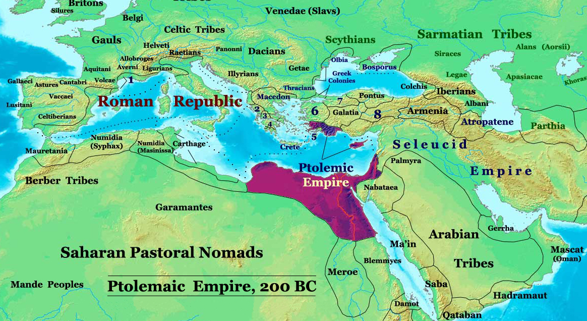
| Descripción | The Ptolemaic Kingdom of Egypt in 200 BC. |
| Fonte | Trabayu propiu |
| Autor | Thomas Lessman (Contact!) |
| Permisu (Cómo reutilizar esti ficheru) |
Yo, el titular de los drechos d'autor d'esta obra, la espublizo baxo la siguiente llicencia: Esti ficheru ta disponible baxo la llicencia Creative Commons Reconocimientu-Compartir igual 3.0 xenérica.
|
| Otres versiones |
Derivative works of this file: Ptolemaic-Empire 200bcARABIC.JPG see below |
Author: Thomas A. Lessman. Source URL: http://www.ThomasLessman.com/History/images/East-Hem_200bc.jpg. Image was created by me (Thomas Lessman) based on my map of Eastern Hemisphere in 200 BC.
Map Summary

Original Source URL: http://www.thomaslessman.com/History/images/East-Hem_200bc.jpg
This map is a zoomed-in version of Thomas Lessman's map of the
East-Hem 200bc.jpg (also available at www.WorldHistoryMaps.info).
Highlighted areas represent lands of the Ptolemaic Kingdom of Egypt in the year 200 BC, during the reign of Ptolemy V Epiphanes (before the 2nd invasion of Antiochus III).
Map Source References
Remember, sources often conflict with each other. This map is only as accurate as the information that is available to me. To report any errors or to help further this work, please click here, or email Thomas Lessman at talessman@yis.us
References for information contained in this map:
Other Maps by Thomas Lessman
| Maps of the eastern hemisphere showing history
Bold dates are available on Wikimedia or Wikipedia. | ||
| Primeval | ||
| Ancient
|
·| 600 BC | 550 BC | 527 BC | 500 BC |
400 BC | ·| 1 AD | 50 AD | 100 AD | 200 AD | 300 AD | | |
| Medieval |
·| 500 AD | 565 AD | 600 AD | 700 AD | | |
| Modern |
·| 1500 AD | · * For historical maps of the whole world, | |
Other Info
Historial del ficheru
Calca nuna fecha/hora pa ver el ficheru como taba daquella.
| Data/Hora | Miniatura | Dimensiones | Usuariu | Comentariu | |
|---|---|---|---|---|---|
| actual | 20:06 3 feb 2010 | | 1164 × 636 (1,02 MB) | Malus Catulus | I missed a spot |
| 20:01 3 feb 2010 |  | 1164 × 636 (1 MB) | Malus Catulus | Removed redundant info according to commons norms | |
| 08:15 20 may 2008 |  | 1164 × 636 (886 kB) | Talessman | {{Information |Description= |Source=self-made |Date= |Author= Talessman |Permission= |other_versions= }} Category:Hellenistic age Category:Maps of Asian history Category:Maps of Ancient Greece Category:Seleucid dynasty |
Usu del ficheru
La páxina siguiente usa esti ficheru:
Usu global del ficheru
Estes otres wikis usen esti ficheru:
- Usu en ar.wikipedia.org
- Usu en be.wikipedia.org
- Usu en bg.wikipedia.org
- Usu en de.wikipedia.org
- Usu en el.wikipedia.org
- Usu en en.wikipedia.org
- Usu en eo.wikipedia.org
- Usu en es.wikipedia.org
- Usu en fa.wikipedia.org
- Usu en fr.wikipedia.org
- Usu en gl.wikipedia.org
- Usu en he.wikipedia.org
- Usu en hu.wikipedia.org
- Usu en hy.wikipedia.org
- Usu en hyw.wikipedia.org
- Usu en id.wikipedia.org
- Usu en it.wikipedia.org
- Usu en ja.wikipedia.org
- Usu en ko.wikipedia.org
- Usu en la.wikipedia.org
- Usu en lt.wikipedia.org
- Usu en mg.wikipedia.org
- Usu en ms.wikipedia.org
- Usu en no.wikipedia.org
- Usu en pnb.wikipedia.org
- Usu en pt.wikipedia.org
- Usu en ru.wikipedia.org
- Usu en sco.wikipedia.org
- Usu en sh.wikipedia.org
- Usu en sl.wikipedia.org
- Usu en sr.wikipedia.org
Ver más usos globales d'esti ficheru.