
Ficheru:Philadelphia skyline from South Street Bridge January 2020 (rotate 2 degrees perspective correction crop 4-1).jpg

Tamañu d'esta previsualización: 800 × 200 pixels. Otres resoluciones: 320 × 80 pixels | 640 × 160 pixels | 1024 × 256 pixels | 3816 × 954 pixels.
Ficheru orixinal (3816 × 954 píxels, tamañu de ficheru: 1,42 MB, triba MIME: image/jpeg)
Resume
| Descripción |
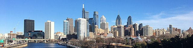
English: The skyline of Philadelphia, Pennsylvania viewed from the South Street Bridge over the Schuylkill River. If on Wikipedia, see the fully annotated version on the Wikimedia page.
|
||
| Data | |||
| Fonte | File:Philadelphia_skyline_from_South_Street_Bridge_January_2020.jpeg | ||
| Autor | Dough4872; modifications and annotations by Maps and stuff (Brian W. Schaller) | ||
| Otres versiones |
|

.jpg)
| Posición de la cámara | | Ubicación de esta y otras imágenes en: OpenStreetMap |
|---|
.jpg¶ms=039.946975_N_-075.186797_E_globe:Earth_type:camera_heading:69.51&language=ast)
Llicencia
Este archivo está disponible bajo la licencia Creative Commons Atribución-CompartirIgual 4.0 Internacional.
- Ye llibre:
- pa compartir – pa copiar, distribuir y comunicar públicamente la obra
- pa remezclar – p'adautar la obra
- Baxo les condiciones siguientes:
- reconocimientu – Tienes de dar el créitu apropiáu, apurrir un enllaz a la llicencia ya indicar si realizasti dalgún cambéu. Puedes faelo de cualquier mou razonable ,pero non de manera que suxera l'encontu del autor pa ti o pal usu que faigas.
- compartir igual – Si entemeces, tresformes o te bases nesti material, tienes de distribuir les tos contribuciones baxo la mesma llicencia o una compatible cola orixinal.
| Annotations | This image is annotated: View the annotations at Commons |
Historial del ficheru
Calca nuna fecha/hora pa ver el ficheru como taba daquella.
| Data/Hora | Miniatura | Dimensiones | Usuariu | Comentariu | |
|---|---|---|---|---|---|
| actual | 14:22 27 xin 2020 | 3816 × 954 (1,42 MB) | Maps and stuff | User created page with UploadWizard |
Usu del ficheru
La páxina siguiente usa esti ficheru:
Usu global del ficheru
Estes otres wikis usen esti ficheru:
- Usu en ang.wikipedia.org
- Usu en ar.wikipedia.org
- Usu en arz.wikipedia.org
- Usu en br.wikipedia.org
- Usu en ca.wikipedia.org
- Usu en ce.wikipedia.org
- Usu en ckb.wikipedia.org
- Usu en cy.wikipedia.org
- Usu en da.wikipedia.org
- Usu en de.wikivoyage.org
- Usu en diq.wikipedia.org
- Usu en en.wikipedia.org
- Usu en en.wikibooks.org
- Usu en en.wikivoyage.org
- Usu en eu.wikipedia.org
- Usu en fr.wikivoyage.org
- Usu en ga.wikipedia.org
- Usu en gl.wikipedia.org
- Usu en ha.wikipedia.org
- Usu en he.wikivoyage.org
- Usu en ht.wikipedia.org
- Usu en ia.wikipedia.org
- Usu en ilo.wikipedia.org
- Usu en incubator.wikimedia.org
- Usu en it.wikipedia.org
- Usu en it.wikivoyage.org
- Usu en ja.wikivoyage.org
- Usu en kab.wikipedia.org
- Usu en lb.wikipedia.org
- Usu en lld.wikipedia.org
- Usu en mhr.wikipedia.org
- Usu en no.wikipedia.org
- Usu en ru.wikipedia.org
- Usu en ru.wikinews.org
- Usu en simple.wikipedia.org
- Usu en sr.wikipedia.org
Ver más usos globales d'esti ficheru.
.jpg)
.jpg)