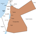
Ficheru:PalestineAndTransjordan.png

Contenido de la página no disponible en otros idiomas.
De Wikipedia

PalestineAndTransjordan.png(636 × 599 píxels, tamañu de ficheru: 65 kB, triba MIME: image/png)

Esti ficheru ye de Wikimedia Commons y puen usalu otros proyeutos. La descripción de la páxina de descripción del ficheru s'amuesa darréu.

File:PalestineAndTransjordan.svg es una versión vectorial de este archivo. Debería usarse esa versión en lugar de este archivo PNG, cuando sea mejor.

File:PalestineAndTransjordan.png → File:PalestineAndTransjordan.svg

Para más información, lee Ayuda:SVG.

En otros idiomas
Alemannisch  Bahasa Indonesia  Bahasa Melayu  British English  català  čeština  dansk  Deutsch  eesti  English  español  Esperanto  euskara  français  Frysk  galego  hrvatski  Ido  italiano  lietuvių  magyar  Nederlands  norsk bokmål  norsk nynorsk  occitan  Plattdüütsch  polski  português  português do Brasil  română  Scots  sicilianu  slovenčina  slovenščina  suomi  svenska  Tiếng Việt  Türkçe  vèneto  Ελληνικά  беларуская (тарашкевіца)  български  македонски  нохчийн  русский  српски / srpski  татарча/tatarça  українська  ქართული  հայերեն  বাংলা  தமிழ்  മലയാളം  ไทย  한국어  日本語  简体中文  繁體中文  עברית  العربية  فارسی  +/−
Nueva imagen SVG

Descripción
English: Map of the British Mandate of Palestine and Transjordan.
Note: Wasserstein, Bernard (2004). Israel and Palestine: Why They Fight and Can They Stop?, pp. 105–106."Palestine, therefore, was not partitioned in 1921–1922. Transjordan was not excised but, on the contrary, added to the mandatory area. Zionism was barred from seeking to expand there – but the Balfour Declaration had never previously applied to the area east of the Jordan. Why is this important? Because the myth of Palestine's 'first partition' has become part of the concept of 'Greater Israel' and of the ideology of Jabotinsky's Revisionist movement."
Fonte

Originally uploaded on the English Wiki (all linking to en.wikipedia):

08:13, 8 June 2005 Doron (Talk / contribs) uploaded "Image:PalestineAndTransjordan.png"
Autor User:Doron
Permisu
(Cómo reutilizar esti ficheru)
GNU head Autorízase la copia, distribución y/o cambéu d'esti documentu baxo los términos de la Llicencia de documentación llibre GNU, versión 1.2 o cualesquier otra que nel futuru espublice la Free Software Foundation; ensin seiciones invariables, testos de portada, nin testos de contraportada. S'inclúi una copia de la llicencia na seición titulada GNU Free Documentation License.
w:es:Creative Commons
reconocimientu compartir igual
Esti ficheru ta disponible baxo la llicencia Creative Commons Reconocimientu-Compartir igual 3.0 xenérica.
Ye llibre:
  • pa compartir – pa copiar, distribuir y comunicar públicamente la obra
  • pa remezclar – p'adautar la obra
Baxo les condiciones siguientes:
  • reconocimientu – Tienes de dar el créitu apropiáu, apurrir un enllaz a la llicencia ya indicar si realizasti dalgún cambéu. Puedes faelo de cualquier mou razonable ,pero non de manera que suxera l'encontu del autor pa ti o pal usu que faigas.
  • compartir igual – Si entemeces, tresformes o te bases nesti material, tienes de distribuir les tos contribuciones baxo la mesma llicencia o una compatible cola orixinal.
Esta etiqueta de llicencia s'amestó a esti ficheru como parte del anovamientu de la llicencia GFDL.
Otres versiones Image:BritishMandatePalestine1920.png

Pies

Añade una explicación corta acerca de lo que representa este archivo

Elementos representados en este archivo

representa a

Historial del ficheru

Calca nuna fecha/hora pa ver el ficheru como taba daquella.

Data/HoraMiniaturaDimensionesUsuariuComentariu
actual15:17 22 mar 2019Miniatura de la versión a fecha de 15:17 22 mar 2019636 × 599 (65 kB)Claude ZygielThis file in clearly definite as "Map of the British Mandate of Palestine '''and''' Transjordan" and used for the both territories
12:01 24 och 2017Miniatura de la versión a fecha de 12:01 24 och 2017636 × 599 (61 kB)Nicola RomaniReverted to version as of 11:02, 22 April 2016 (UTC)
17:04 30 ago 2017Miniatura de la versión a fecha de 17:04 30 ago 2017675 × 542 (51 kB)OnceinawhileConverted into new svg - this is the png version
16:07 19 och 2016Miniatura de la versión a fecha de 16:07 19 och 2016636 × 599 (65 kB)Claude ZygielThis file in clearly definite as "Map of the British Mandate of Palestine '''and''' Transjordan" and used for the both territories.
11:02 22 abr 2016Miniatura de la versión a fecha de 11:02 22 abr 2016636 × 599 (61 kB)Makeandtossoops
11:01 22 abr 2016Miniatura de la versión a fecha de 11:01 22 abr 2016636 × 599 (61 kB)MakeandtossRemoved Mandatory Palestine since picture is used to refer to only the emirate
15:49 4 avi 2011Miniatura de la versión a fecha de 15:49 4 avi 2011636 × 599 (66 kB)Wickey-nlthicker lining around lake
21:43 3 avi 2011Miniatura de la versión a fecha de 21:43 3 avi 2011636 × 599 (66 kB)Wickey-nlFixed border
15:29 29 xin 2011Miniatura de la versión a fecha de 15:29 29 xin 2011636 × 599 (77 kB)VadacFixed border of Transjordan within the Mandate of Palestine with Saudi Arabia per the present border having been drawn in 1965 as seen here.
11:29 24 feb 2006Miniatura de la versión a fecha de 11:29 24 feb 2006636 × 599 (89 kB)Lohen11Palestine from:

Nun hai páxines qu'usen esti ficheru.

Usu global del ficheru

Estes otres wikis usen esti ficheru:

Ver más usos globales d'esti ficheru.

Metadatos