
Ficheru:Northumberland Strait map.png
Tamañu d'esta previsualización: 800 × 541 pixels. Otres resoluciones: 320 × 216 pixels | 640 × 433 pixels | 1024 × 692 pixels | 1280 × 865 pixels | 2500 × 1690 pixels.
Ficheru orixinal (2500 × 1690 píxels, tamañu de ficheru: 240 kB, triba MIME: image/png)
Resume
| Descripción |
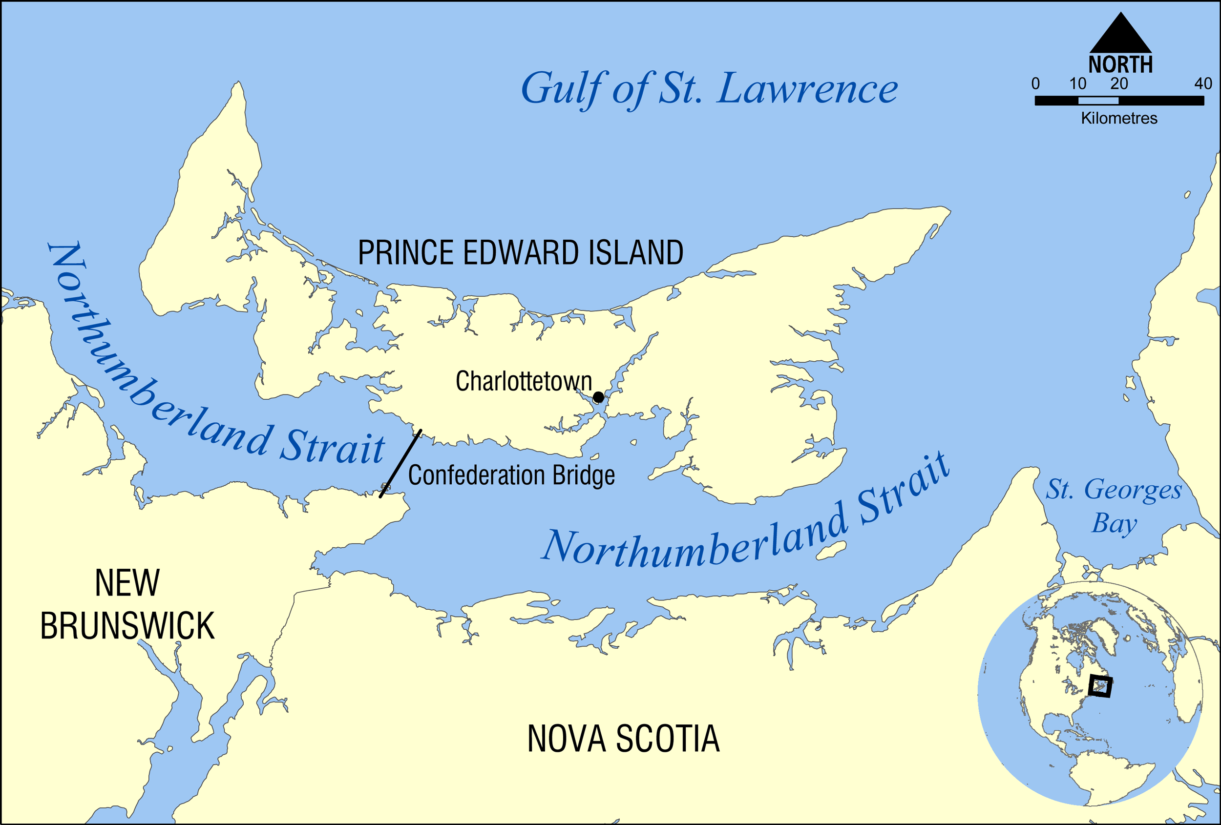
English: This map shows the location of the Northumberland Strait in the Gulf of St. Lawrence, separating the Canadian provinces of Prince Edward Island and New Brunswick.
Deutsch: Die Karte zeigt die Lage der Northumberlandstraße im Sankt-Lorenz-Golf sowie die Confederation Bridge, welche das kanadische Festland an seiner engsten Stelle mit der Provinz Prince Edward Island verbindet. |
| Data | |
| Fonte | Trabayu propiu |
| Autor | NormanEinstein |
Llicencia
Yo, el titular de los drechos d'autor d'esta obra, la espublizo baxo les siguientes llicencies:
Esti ficheru ta disponible baxo la llicencia Creative Commons Reconocimientu-Compartir igual 3.0 xenérica.
- Ye llibre:
- pa compartir – pa copiar, distribuir y comunicar públicamente la obra
- pa remezclar – p'adautar la obra
- Baxo les condiciones siguientes:
- reconocimientu – Tienes de dar el créitu apropiáu, apurrir un enllaz a la llicencia ya indicar si realizasti dalgún cambéu. Puedes faelo de cualquier mou razonable ,pero non de manera que suxera l'encontu del autor pa ti o pal usu que faigas.
- compartir igual – Si entemeces, tresformes o te bases nesti material, tienes de distribuir les tos contribuciones baxo la mesma llicencia o una compatible cola orixinal.

|
Autorízase la copia, distribución y/o cambéu d'esti documentu baxo los términos de la Llicencia de documentación llibre GNU, versión 1.2 o cualesquier otra que nel futuru espublice la Free Software Foundation; ensin seiciones invariables, testos de portada, nin testos de contraportada. S'inclúi una copia de la llicencia na seición titulada GNU Free Documentation License. |
Pues seleicionar la llicencia que prefieras.
Historial del ficheru
Calca nuna fecha/hora pa ver el ficheru como taba daquella.
| Data/Hora | Miniatura | Dimensiones | Usuariu | Comentariu | |
|---|---|---|---|---|---|
| actual | 19:57 4 feb 2009 | | 2500 × 1690 (240 kB) | NormanEinstein | {{Information |Description={{en|1=This map shows the location of the Northumberland Strait in the Gulf of St. Lawrence, separating the Canadian provinces of Prince Edward Island and New Brunswick. }} |Source=Own work by uploader |Author=[[User:NormanEinst |
Usu del ficheru
Nun hai páxines qu'usen esti ficheru.
Usu global del ficheru
Estes otres wikis usen esti ficheru:
- Usu en bn.wikipedia.org
- Usu en de.wikipedia.org
- Usu en en.wikipedia.org
- Usu en es.wikipedia.org
- Usu en fa.wikipedia.org
- Usu en it.wikipedia.org
- Usu en ja.wikipedia.org
- Usu en nn.wikipedia.org
- Usu en pl.wikipedia.org
- Usu en pt.wikipedia.org
- Usu en ru.wikipedia.org
- Usu en uk.wikipedia.org
- Usu en zh.wikipedia.org