
Ficheru:Northern icesheet-fr.png

Tamañu d'esta previsualización: 800 × 587 pixels. Otres resoluciones: 320 × 235 pixels | 640 × 469 pixels | 1024 × 751 pixels | 1280 × 939 pixels | 2236 × 1640 pixels.
Ficheru orixinal (2236 × 1640 píxels, tamañu de ficheru: 402 kB, triba MIME: image/png)
Resume
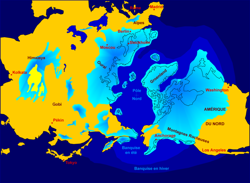
| Descripción | Northern hemisphere glaciation during the last ice ages. The set up of 3 to 4 km thick ice sheets caused a sea level lowering of about 120 m. Also the Alps and the Himalaya were covered by glaciers. The limit of winter sea ice coverage was much more to the south. |
| Data | 2000-04-07, modified October 2006 |
| Fonte | Image:Northern_icesheet_hg.png created by Hannes Grobe |
| Autor | Hannes Grobe 23:06, 21 July 2006 (UTC), Alfred Wegener Institute for Polar and Marine Research, Bremerhaven, Germany, translated by Sting |
| Permisu (Cómo reutilizar esti ficheru) |
share alike, attribution required (Creative Commons CC-BY-SA-2.5) |
| Otres versiones |
in English : Image:Northern_icesheet_hg.png USGS map |
Français : * Sujet : Carte de l'hémisphère nord durant la dernière glaciation. Une couche de glace de 3 à 4 km d'épaisseur a entraîné un abaissement du niveau de la mer d'environ 120 m. Les Alpes et l'Himalaya étaient recouverts par des glaciers. L'extension de la banquise en hiver allait bien plus au Sud qu'actuellement ;
- Source : Image:Northern_icesheet_hg.png créée par Hannes Grobe ;
- Auteur : Hannes Grobe, cette version par fr:Sting ;
- Date : Avril 2000, modifications : octobre 2006 ;
- Version originale anglophone : Image:Northern_icesheet_hg.png ;
- Version alternative : carte USGS (lien externe).
Llicencia
Este archivo se encuentra bajo la licencia Creative Commons Genérica de Atribución/Compartir-Igual 2.5.
- Ye llibre:
- pa compartir – pa copiar, distribuir y comunicar públicamente la obra
- pa remezclar – p'adautar la obra
- Baxo les condiciones siguientes:
- reconocimientu – Tienes de dar el créitu apropiáu, apurrir un enllaz a la llicencia ya indicar si realizasti dalgún cambéu. Puedes faelo de cualquier mou razonable ,pero non de manera que suxera l'encontu del autor pa ti o pal usu que faigas.
- compartir igual – Si entemeces, tresformes o te bases nesti material, tienes de distribuir les tos contribuciones baxo la mesma llicencia o una compatible cola orixinal.
Historial del ficheru
Calca nuna fecha/hora pa ver el ficheru como taba daquella.
| Data/Hora | Miniatura | Dimensiones | Usuariu | Comentariu | |
|---|---|---|---|---|---|
| actual | 19:16 22 och 2006 | | 2236 × 1640 (402 kB) | Sting | {{Information| |Description=Northern hemisphere glaciation during the last ice ages. The set up of 3 to 4 km thick ice sheets caused a sea level lowering of about 120 m. Also the Alps and the Himalya were covered by glaciers. The limit of winter sea ice c |
Usu del ficheru
La páxina siguiente usa esti ficheru:
Usu global del ficheru
Estes otres wikis usen esti ficheru:
- Usu en az.wikipedia.org
- Usu en de.wikipedia.org
- Usu en fr.wikipedia.org
- Pléistocène
- Glaciation
- Inlandsis
- Géographie de la Colombie-Britannique
- Histoire de l'humanité
- Wikipédia:Atelier graphique/Images à améliorer/Archives/Novembre 2006
- Archipel finlandais
- Wikipédia:Sélection/Paléontologie (période géologique)
- Wikipédia:Lumière sur/Pléistocène
- Wikipédia:Oracle/semaine 48 2011
- Utilisateur:Orbitale/Brouillon Dernière période glaciaire
- Dernière période glaciaire
- Climat de l'Arctique
- Usu en gl.wikipedia.org
- Usu en ko.wikipedia.org
- Usu en www.wikidata.org