
Ficheru:Morocco relief location map.jpg

Tamañu d'esta previsualización: 737 × 600 pixels. Otres resoluciones: 295 × 240 pixels | 590 × 480 pixels | 944 × 768 pixels | 1223 × 995 pixels.
Ficheru orixinal (1223 × 995 píxels, tamañu de ficheru: 265 kB, triba MIME: image/jpeg)
Resume
| Descripción |
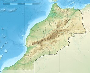
English: Blank physical map of Morocco, for geo-location purposes.
Français : Carte physique vierge du Maroc, destinée à la géolocalisation. Scale: 1:4,000,000 (precision: 1,000 m)
Geographic limits of the map:
|
||
| Data | 2009-11, updated 2017-02 | ||
| Fonte |
Trabayu propiu
|
||
| Autor | Eric Gaba (Sting - fr:Sting) | ||
| Permisu (Cómo reutilizar esti ficheru) |
|
||
| Otres versiones |
|

| Posición de la cámara | | Ubicación de esta y otras imágenes en: OpenStreetMap |
|---|
Llicencia
Yo, el titular de los drechos d'autor d'esta obra, la espublizo baxo les siguientes llicencies:
Esti ficheru ta disponible baxo la llicencia Creative Commons Reconocimientu-Compartir igual 3.0 xenérica.
- Ye llibre:
- pa compartir – pa copiar, distribuir y comunicar públicamente la obra
- pa remezclar – p'adautar la obra
- Baxo les condiciones siguientes:
- reconocimientu – Tienes de dar el créitu apropiáu, apurrir un enllaz a la llicencia ya indicar si realizasti dalgún cambéu. Puedes faelo de cualquier mou razonable ,pero non de manera que suxera l'encontu del autor pa ti o pal usu que faigas.
- compartir igual – Si entemeces, tresformes o te bases nesti material, tienes de distribuir les tos contribuciones baxo la mesma llicencia o una compatible cola orixinal.

|
Autorízase la copia, distribución y/o cambéu d'esti documentu baxo los términos de la Llicencia de documentación llibre GNU, versión 1.2 o cualesquier otra que nel futuru espublice la Free Software Foundation; ensin seiciones invariables, testos de portada, nin testos de contraportada. S'inclúi una copia de la llicencia na seición titulada GNU Free Documentation License. |
Pues seleicionar la llicencia que prefieras.
Historial del ficheru
Calca nuna fecha/hora pa ver el ficheru como taba daquella.
| Data/Hora | Miniatura | Dimensiones | Usuariu | Comentariu | |
|---|---|---|---|---|---|
| actual | 20:55 10 feb 2017 | | 1223 × 995 (265 kB) | Sting | Updated regions borders as since 2015 |
| 13:11 19 xnt 2010 |  | 1223 × 995 (234 kB) | Sting | Color profile | |
| 20:31 21 pay 2009 |  | 1223 × 995 (240 kB) | Sting | Putting back the southern dotted boundary (regarding Western Sahara's location map) | |
| 01:23 21 pay 2009 |  | 1223 × 995 (239 kB) | Sting | Drawback for one "correction" | |
| 01:10 21 pay 2009 |  | 1223 × 995 (240 kB) | Sting | Several little corrections | |
| 00:09 21 pay 2009 |  | 1223 × 995 (241 kB) | Sting | == {{int:filedesc}} == {{Location|31|46|30|N|7|04|30|W|scale:5000000}} <br/> {{Information |Description={{en|Blank physical map of Morocco, for geo-location purposes.}} {{fr|Carte physique vierge du Maroc, destinée à la gé |
Usu del ficheru
Les páxines siguientes usen esti ficheru:
Usu global del ficheru
Estes otres wikis usen esti ficheru:
- Usu en af.wikipedia.org
- Usu en ar.wikipedia.org
- Usu en azb.wikipedia.org
- Usu en az.wikipedia.org
- Usu en ba.wikipedia.org
- Usu en be.wikipedia.org
- Usu en bg.wikipedia.org
Ver más usos globales d'esti ficheru.