
Ficheru:Mexico City ESA412648.jpg

Ficheru orixinal (7288 × 4599 píxels, tamañu de ficheru: 9,14 MB, triba MIME: image/jpeg)
Resume
| Descripción |
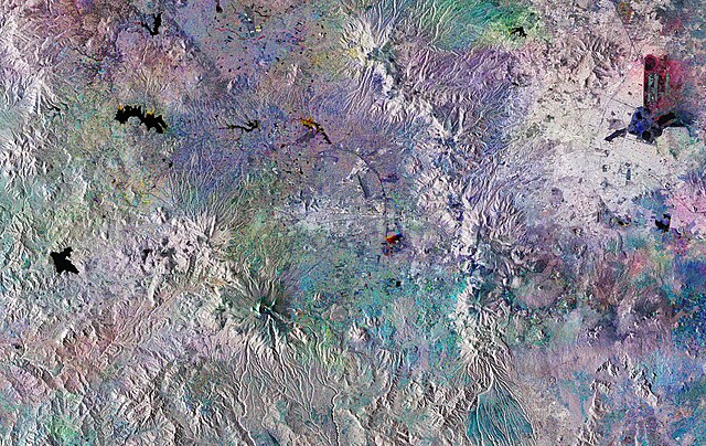
English: The Copernicus Sentinel-1 mission takes us over Mexico City. This huge, densely-populated capital can be seen in the top right of the image. It is home to almost nine million people, with the Greater Mexico City area recording a population of over 21 million. This makes it the largest Spanish-speaking city in the world.
This striking image has been created using three Copernicus Sentinel-1 acquisitions from 28 July, 27 August and 26 September 2018, overlaid in red, green and blue, respectively. Where we see explosions of colour, changes have occurred between the different acquisitions. In the left of the image, three bodies of water are shown in black: Villa Victoria, Valle de Bravo, and Tepetitlán. Water is significant to the development of Mexico City, which is thought to have been built over a lake by the Aztecs around 1325. Today, the city finds itself in a precarious situation in terms of water supply in spite of the regular flash floods and heavy rainfall it experiences during the wet season from June and September. In the top right, we can see the round structure of El Caracol meaning ‘the snail’ in Spanish. Currently used as a reservoir for industrial facilities within Mexico City, there are plans for this to become a wastewater treatment plant. A 62 km-long sewer tunnel is also due to begin operating this year. The Cumbres del Ajusco national park is shown to the southwest of the capital, in an area of the image that shows colourful dots forming a circle. Famous for being up to almost 4000 m above sea level at its highest elevation, it is one of many national parks surrounding the capital. Volcanoes are also dotted around this area. Popocatépetl, to the south east of Mexico City, last erupted in September 2018. Sentinel-1 is a two-satellite mission to supply the coverage and data delivery needed for Europe’s Copernicus environmental monitoring programme. The satellites each carry an advanced radar instrument to provide an all-weather, day-and-night supply of imagery of Earth’s surface. This image is also featured on theEarth from Space video programme. |
| Data | Tomada en 2018 |
| Fonte | http://www.esa.int/spaceinimages/Images/2018/11/Mexico_City |
| Autor | European Space Agency |
| Permisu (Cómo reutilizar esti ficheru) |
contains modified Copernicus Sentinel data (2018), processed by ESA,CC BY-SA 3.0 IGO |
| Otres versiones |
|
| Title | Mexico City |
| System | Copernicus |
| Set | Earth observation image of the week |
| Mission | Sentinel-1 |
| Activity | Observing the Earth |

Llicencia
This media was created by the European Space Agency (ESA).
Where expressly so stated, images or videos are covered by the Creative Commons Attribution-ShareAlike 3.0 IGO (CC BY-SA 3.0 IGO) licence, ESA being an Intergovernmental Organisation (IGO), as defined by the CC BY-SA 3.0 IGO licence. The user is allowed under the terms and conditions of the CC BY-SA 3.0 IGO license to Reproduce, Distribute and Publicly Perform the ESA images and videos released under CC BY-SA 3.0 IGO licence and the Adaptations thereof, without further explicit permission being necessary, for as long as the user complies with the conditions and restrictions set forth in the CC BY-SA 3.0 IGO licence, these including that:
See the ESA Creative Commons copyright notice for complete information, and this article for additional details.
|
 | |
Este archivo se encuentra bajo la licencia Creative Commons Atribución Compartir-Igual 3.0 IGO. Reconocimientu: ESA, CC BY-SA IGO 3.0
| ||

|
Esta imagen contiene datos que provienen de un satélite del Programa Copérnico, como Sentinel-1, Sentinel 2 o Sentinel-3. Se require atribución cuando se utilice esta imagen.
Reconocimientu: Contiene datos modificados de Copernicus Sentinel 2018
El uso de datos Sentinel del Programa Cópernico está regulado por la legislación europea: Reglamento Delegado (UE) No 1159/2013 de la Comisión y el Reglamento (UE) No 377/2014. Los pasajes relevantes son:
Se permitirá el acceso gratuito a los datos dedicados del GMES y a la información de servicio del GMES a través de las plataformas de difusión del GMES [...].
Se dará acceso a los datos dedicados del GMES y a la información de servicio del GMES a los efectos que se detallan a continuación, siempre y cuando sean lícitos:
Los datos dedicados del GMES y la información de servicio del GMES podrán utilizarse en todo el mundo sin limitación de tiempo.
Los datos dedicados del GMES y la información de servicio del GMES se facilitarán a los usuarios sin ninguna garantía explícita o implícita, incluyendo lo tocante a la calidad y la idoneidad para cualesquiera fines. |
Historial del ficheru
Calca nuna fecha/hora pa ver el ficheru como taba daquella.
| Data/Hora | Miniatura | Dimensiones | Usuariu | Comentariu | |
|---|---|---|---|---|---|
| actual | 13:14 3 abr 2019 | | 7288 × 4599 (9,14 MB) | Fæ | European Space Agency, Id 412648, http://www.esa.int/spaceinimages/Images/2018/11/Mexico_City, User:Fæ/Project_list/ESA |
Usu del ficheru
La páxina siguiente usa esti ficheru:
Usu global del ficheru
Estes otres wikis usen esti ficheru:
- Usu en arz.wikipedia.org
- Usu en ca.wikipedia.org
- Usu en ceb.wikipedia.org
- Usu en ce.wikipedia.org
- Usu en cy.wikipedia.org
- Usu en da.wikipedia.org
- Usu en de.wikivoyage.org
- Usu en el.wikipedia.org
- Usu en eo.wikipedia.org
- Usu en fi.wikipedia.org
- Usu en fr.wikivoyage.org
- Usu en ga.wikipedia.org
- Usu en gl.wikipedia.org
- Usu en he.wikipedia.org
- Usu en hy.wikipedia.org
- Usu en ia.wikipedia.org
- Usu en ilo.wikipedia.org
- Usu en mzn.wikipedia.org
- Usu en nn.wikipedia.org
- Usu en no.wikipedia.org
- Usu en pl.wikipedia.org
- Usu en pt.wikipedia.org
- Usu en ro.wikipedia.org
- Usu en ru.wikipedia.org
- Usu en sk.wikipedia.org
- Usu en sr.wikipedia.org
- Usu en tt.wikipedia.org
- Usu en uk.wikipedia.org
- Usu en vec.wikipedia.org
- Usu en vi.wikipedia.org
- Usu en www.wikidata.org