
Ficheru:Mediaeval universities.jpg
Tamañu d'esta previsualización: 685 × 599 pixels. Otres resoluciones: 274 × 240 pixels | 549 × 480 pixels | 878 × 768 pixels | 1127 × 986 pixels.
Ficheru orixinal (1127 × 986 píxels, tamañu de ficheru: 1,17 MB, triba MIME: image/jpeg)
Resume
| Descripción |
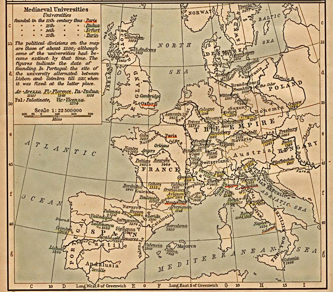
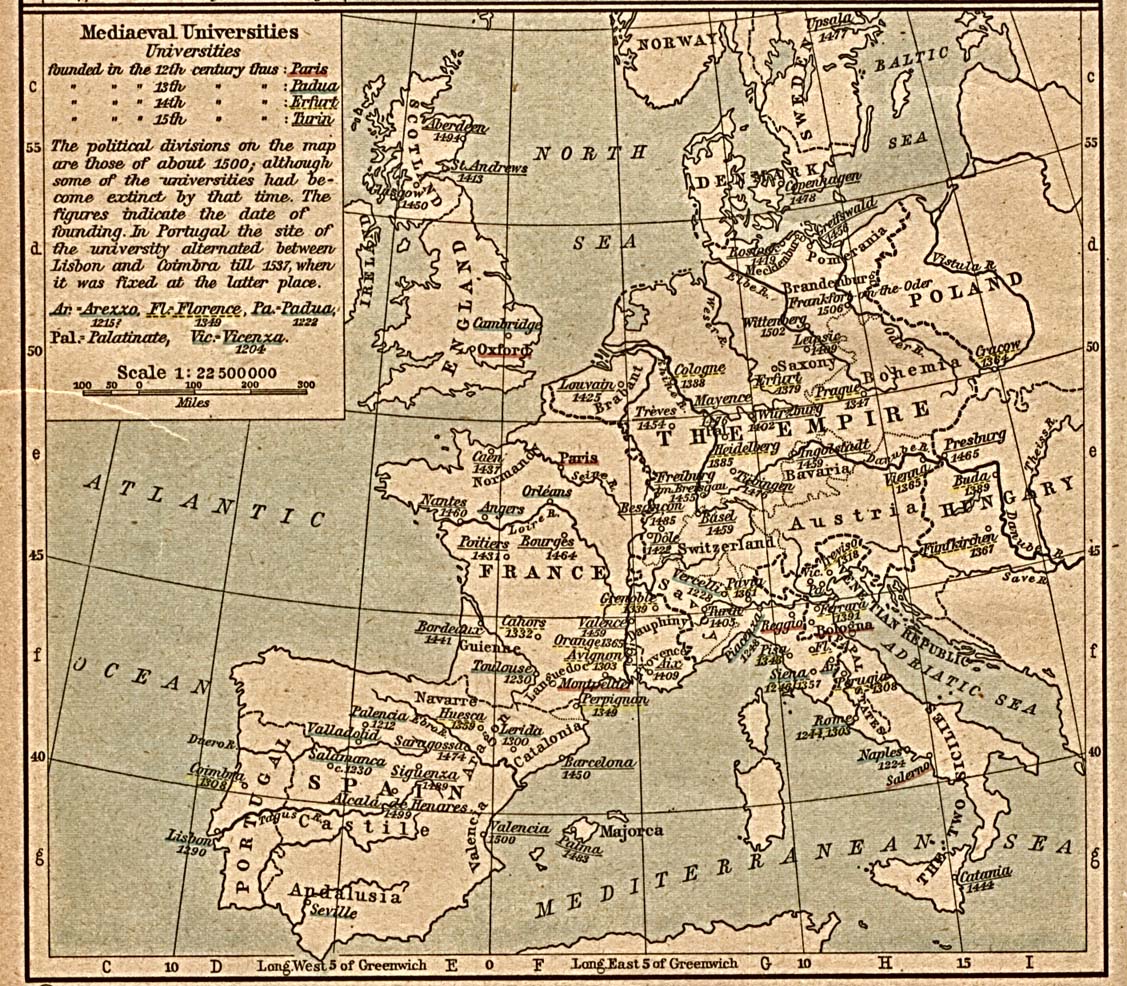
English: Scan from "Historical Atlas" by William R. Shepherd, New York, Henry Holt and Company, 1923. |
||||||||||||||||||||||
| Data | (the same map was included on a half-page in the 1911 edition) | ||||||||||||||||||||||
| Fonte | |||||||||||||||||||||||
| Autor |
|
||||||||||||||||||||||
| Permisu (Cómo reutilizar esti ficheru) |
From the FAQ @ http://www.lib.utexas.edu/maps/faq.html
|
||||||||||||||||||||||
| Otres versiones | العربيَّة | ||||||||||||||||||||||
Llicencia
Esta obra está en el dominio público en los Estados Unidos porque fue publicada (o registrada con la Oficina del Derecho de Autor de los E.E. U.U.) antes del 1 de enero de 1929.
Los trabajos en el dominio público deben haber expirado su copyright en los Estados Unidos y en el país de origen para ser subidos a Commons. Si el trabajo no es un trabajo estadounidense, el archivo debe tener una marca de derechos de autor adicional indicando el estatus del copyright del país de origen.
|
Rexistru de xubíes orixinal
Transferred from en.wikipedia to Commons by SreeBot.
The original description page was here. All following user names refer to en.wikipedia.
Upload date | User | Bytes | Dimensions | Comment
- 2006-12-18 21:40 (UTC) | Jengod | 361656 (bytes) | 1127×986 | {{PD}} Scan from "Historical Atlas" by William R. Shepherd, New York, Henry Holt and Company, 1923. Original image at the [http://www.lib.utexas.edu/maps/ Perry-Castañeda Library Map Collection] at the [[University of Texas at Austin]] website: http:/
Historial del ficheru
Calca nuna fecha/hora pa ver el ficheru como taba daquella.
| Data/Hora | Miniatura | Dimensiones | Usuariu | Comentariu | |
|---|---|---|---|---|---|
| actual | 16:31 30 xnt 2012 | | 1127 × 986 (1,17 MB) | SteveMcCluskey | Improved legibility by reducing extraneous background detail, increasing contrast of image, and enhancing color saturation of underlining. |
| 18:38 20 set 2011 |  | 1127 × 986 (353 kB) | SreeBot | (Original text) : {{PD}} Scan from "Historical Atlas" by William R. Shepherd, New York, Henry Holt and Company, 1923. Original image at the [http://www.lib.utexas.edu/maps/ Perry-Castañeda Library Map Collection] at the [[University of Texas at Austin |
Usu del ficheru
La páxina siguiente usa esti ficheru:
Usu global del ficheru
Estes otres wikis usen esti ficheru:
- Usu en azb.wikipedia.org
- Usu en az.wikipedia.org
- Usu en ca.wikipedia.org
- Usu en cs.wikipedia.org
- Usu en en.wikipedia.org
- Usu en es.wikipedia.org
- Usu en fr.wikipedia.org
- Usu en id.wikipedia.org
- Usu en ja.wikipedia.org
- Usu en ka.wikipedia.org
- Usu en pt.wikipedia.org
- Usu en sq.wikipedia.org
- Usu en uk.wikipedia.org
- Usu en uz.wikipedia.org
- Usu en www.wikidata.org