Ficheru:Maurya Empire, c.250 BCE 2.png

Contenido de la página no disponible en otros idiomas.
De Wikipedia

Ficheru orixinal(1200 × 1121 píxels, tamañu de ficheru: 2,26 MB, triba MIME: image/png)

Esti ficheru ye de Wikimedia Commons y puen usalu otros proyeutos. La descripción de la páxina de descripción del ficheru s'amuesa darréu.

Resume

Descripción
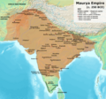
English: Note: This was the standard "textbook" map of the Maurya Empire. Historians are now arguing that the Maurya Empire did not include large parts of India, which were controlled by autonomous tribes. For such a map, see File:Maurya Empire, c.250 BCE.png.
Alternative map of Maurya Empire

Boundaries are based on Charles Joppen Historical Atlas of India (1907), see File:India_in_250_B._C.jpg.

Other Sources:

Other sources:

  • Grainger, John D. (1990, 2014). Seleukos Nikator: Constructing a Hellenistic Kingdom. Routledge.
  • Keay, John (2000). India, a History. New York: Harper Collins Publishers.
  • Kulke, H.; Rothermund, D. (2004). A History of India, 4th, Routledge.
  • Puri, Baji Nath (1996). Buddhism in Central Asia. Delhi: Motilal Banarsidass.
  • Raychaudhuri, H. C.; Mukherjee, B. N. (1996). Political History of Ancient India: From the Accession of Parikshit to the Extinction of the Gupta Dynasty. Oxford University Press.
  • Stein, Burton (1998). A History of India (1st ed.), Oxford: Wiley-Blackwell.

Notes:

  • Sri Lanka and the southernmost parts of India (modern Tamil Nadu and Kerala) remained independent, despite the diplomacy and cultural influence of their larger neighbor to the north (Schwartzberg 1992, p. 18; Kulke & Rothermund 2004, p. 68).
  • The account of Strabo indicates that the western-most territory of the empire extended from the southeastern Hindu Kush, through the region of Kandahar, to coastal Baluchistan south of that (Raychaudhuri & Mukherjee 1996, p. 594).
  • The claim that Aria/Herat was one of the provinces (alongside Arachosia, Gedrosia, and Paropamisadae) ceded by Seleucus to Chandragupta Maurya is often repeated, but Aria (modern Herat) "has been wrongly included in the list of ceded satrapies by some scholars [...] on the basis of wrong assessments of the passage of Strabo [...] and a statement by Pliny." (Raychaudhuri & Mukherjee 1996, p. 594). Seleucus "must [...] have held Aria", and furthermore, his "son Antiochos was active there fifteen years later." (Grainger 2014, p. 109).
  • "The region of Aria is definitely known to have been Seleucid under Seleucus I and Antiochus I as it definitely was after Antiochus III's great campaign in the east against the Parthians and Bactrians. [...] There is no evidence whatever that it did not remain Seleucid, like Drangiana, with which it is linked by easy routes." -Susan M. Sherwin-White and Amélie Kuhrt (1993) From Samarkhand to Sardis: A New Approach to the Seleucid Empire, University of California Press, pp.79-80.
  • It is recorded that Drangiana province continued to be in the Seleucids' hands, as per [1].
  • "Desert of Gedrosia [...] was left an unclaimed wilderness." —Kosmin, Paul J. (2014), The Land of the Elephant Kings Space, Territory, and Ideology in the Seleucid Empire, Harvard University Press, p.16
  • Schwartzberg (p. 18) speculates about the Buddhist culture and Kharosthi inscriptions/manuscripts found in Khotan, but these texts from Khotan, Turfan, and Tajikstan have all been shown to be later than the 1st century BCE (Puri, p. 185).
Data
Fonte Trabayu propiu
Autor Avantiputra7

Llicencia

Yo, el titular de los drechos d'autor d'esta obra, la espublizo baxo la siguiente llicencia:
w:es:Creative Commons
reconocimientu compartir igual
Esti ficheru ta disponible baxo la llicencia Creative Commons Reconocimientu-Compartir igual 3.0 xenérica.
Ye llibre:
  • pa compartir – pa copiar, distribuir y comunicar públicamente la obra
  • pa remezclar – p'adautar la obra
Baxo les condiciones siguientes:
  • reconocimientu – Tienes de dar el créitu apropiáu, apurrir un enllaz a la llicencia ya indicar si realizasti dalgún cambéu. Puedes faelo de cualquier mou razonable ,pero non de manera que suxera l'encontu del autor pa ti o pal usu que faigas.
  • compartir igual – Si entemeces, tresformes o te bases nesti material, tienes de distribuir les tos contribuciones baxo la mesma llicencia o una compatible cola orixinal.

Pies

Añade una explicación corta acerca de lo que representa este archivo

Elementos representados en este archivo

representa a

tipo de archivo español

image/png

Historial del ficheru

Calca nuna fecha/hora pa ver el ficheru como taba daquella.

(lo más nuevo | lo más antiguo) Ver (10 siguientes | ) (10 | 20 | 50 | 100 | 250 | 500)
Data/HoraMiniaturaDimensionesUsuariuComentariu
actual11:01 30 abr 2024Miniatura de la versión a fecha de 11:01 30 abr 20241200 × 1121 (2,26 MB)Avantiputra7western borders: see talk page
04:37 16 abr 2024Miniatura de la versión a fecha de 04:37 16 abr 20241200 × 1121 (2,26 MB)Avantiputra7Reverted to version as of 11:12, 5 April 2024 (UTC) - vandalism
07:37 14 abr 2024Miniatura de la versión a fecha de 07:37 14 abr 20241200 × 1121 (2,18 MB)Layman7676Reverted to version as of 11:12, 4 April 2024 (UTC) The map you are publishing isn't based on wha vincient Arthur really said.
11:12 5 abr 2024Miniatura de la versión a fecha de 11:12 5 abr 20241200 × 1121 (2,26 MB)Avantiputra7Reverted to version as of 08:27, 3 April 2024 (UTC) - vandalism
11:12 4 abr 2024Miniatura de la versión a fecha de 11:12 4 abr 20241200 × 1121 (2,18 MB)Chakravartin1929Reverted to version as of 05:41, 26 March 2024 (UTC) This is the true map. It depicts The mauryan map accurately.
08:27 3 abr 2024Miniatura de la versión a fecha de 08:27 3 abr 20241200 × 1121 (2,26 MB)Avantiputra7Reverted to version as of 11:06, 3 March 2024 (UTC)
05:41 26 mar 2024Miniatura de la versión a fecha de 05:41 26 mar 20241200 × 1121 (2,18 MB)Chakravartin1929Reverted to version as of 09:06, 3 March 2024 (UTC)
11:06 3 mar 2024Miniatura de la versión a fecha de 11:06 3 mar 20241200 × 1121 (2,26 MB)Avantiputra7Reverted to version as of 11:10, 29 January 2024 (UTC)
09:06 3 mar 2024Miniatura de la versión a fecha de 09:06 3 mar 20241200 × 1121 (2,18 MB)Chakravartin1929Reverted to version as of 16:50, 14 December 2023 (UTC) This map is better.
11:10 29 xin 2024Miniatura de la versión a fecha de 11:10 29 xin 20241200 × 1121 (2,26 MB)Avantiputra7tweaked
(lo más nuevo | lo más antiguo) Ver (10 siguientes | ) (10 | 20 | 50 | 100 | 250 | 500)

Nun hai páxines qu'usen esti ficheru.

Usu global del ficheru

Estes otres wikis usen esti ficheru:

Ver más usos globales d'esti ficheru.

Metadatos