
Ficheru:Mauritius Island map-fr.svg

Tamañu de la vista previa PNG d'esti ficheru SVG: 502 × 599 pixels. Otres resoluciones: 201 × 240 pixels | 402 × 480 pixels | 643 × 768 pixels | 858 × 1024 pixels | 1716 × 2048 pixels | 1810 × 2160 pixels.
Ficheru orixinal (ficheru SVG, 1810 × 2160 píxels nominales, tamañu de ficheru: 1,44 MB)

Resume
| Posición de la cámara | | Ubicación de esta y otras imágenes en: OpenStreetMap |
|---|
| Descripción |
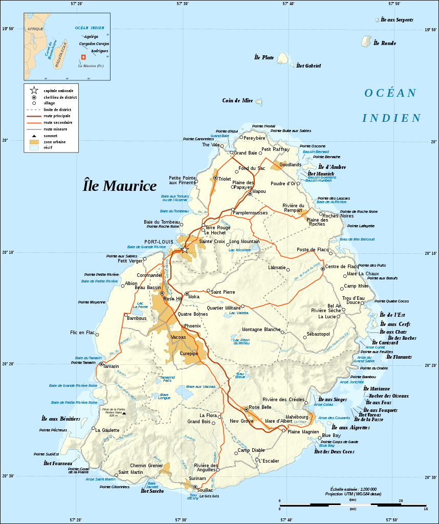
English: Map in French of Mauritius Island
Note : The shaded relief is a raster image embedded in the SVG file. Français : Carte en français de l'île Maurice, Maurice ; Note : Les ombres du relief sont une image bitmap embarquée dans le fichier SVG.
|
||
| Data | |||
| Fonte |
Own work ;
|
||
| Autor | Eric Gaba (Sting - fr:Sting) | ||
| Permisu (Cómo reutilizar esti ficheru) |
|
||
| Otres versiones |
[]
|


|
Esti ficheru SVG tien testu integráu que pue traducise fácilmente a la to llingua usando un editor de SVG como Inkscape o Adobe Illustrator. Ver más. Tamién pues descargalu y traducilu de mou manual usando un editor de testu. |
Llicencia
Yo, el titular de los drechos d'autor d'esta obra, la espublizo baxo les siguientes llicencies:

|
Autorízase la copia, distribución y/o cambéu d'esti documentu baxo los términos de la Llicencia de documentación llibre GNU, versión 1.2 o cualesquier otra que nel futuru espublice la Free Software Foundation; ensin seiciones invariables, testos de portada, nin testos de contraportada. S'inclúi una copia de la llicencia na seición titulada GNU Free Documentation License. |
This file is licensed under the Creative Commons Attribution-Share Alike Attribution-Share Alike 4.0 International, 3.0 Unported, 2.5 Generic, 2.0 Generic and 1.0 Generic license.
- Ye llibre:
- pa compartir – pa copiar, distribuir y comunicar públicamente la obra
- pa remezclar – p'adautar la obra
- Baxo les condiciones siguientes:
- reconocimientu – Tienes de dar el créitu apropiáu, apurrir un enllaz a la llicencia ya indicar si realizasti dalgún cambéu. Puedes faelo de cualquier mou razonable ,pero non de manera que suxera l'encontu del autor pa ti o pal usu que faigas.
- compartir igual – Si entemeces, tresformes o te bases nesti material, tienes de distribuir les tos contribuciones baxo la mesma llicencia o una compatible cola orixinal.
Pues seleicionar la llicencia que prefieras.
Historial del ficheru
Calca nuna fecha/hora pa ver el ficheru como taba daquella.
| Data/Hora | Miniatura | Dimensiones | Usuariu | Comentariu | |
|---|---|---|---|---|---|
| actual | 13:37 25 xnt 2008 | | 1810 × 2160 (1,44 MB) | Sting | + forgotten elements in legend |
| 04:15 25 xnt 2008 |  | 1810 × 2160 (1,44 MB) | Sting | Other correction | |
| 04:08 25 xnt 2008 |  | 1810 × 2160 (1,44 MB) | Sting | Correction | |
| 03:53 25 xnt 2008 |  | 1810 × 2160 (1,44 MB) | Sting | == Summary == {{Location|20|15|00|S|57|35|00|E|scale:500000}} <br/> {{Information |Description={{en|Map in French of Mauritius Island<br/>''Note :'' The shaded relief is a raster image embedded in the SVG file.}} {{fr|Carte en français |
Usu del ficheru
La páxina siguiente usa esti ficheru:
Usu global del ficheru
Estes otres wikis usen esti ficheru:
- Usu en bs.wikipedia.org
- Usu en en.wikipedia.org
- Usu en es.wikipedia.org
- Usu en fa.wikipedia.org
- Usu en fr.wikipedia.org
- Usu en mt.wikipedia.org
- Usu en sh.wikipedia.org