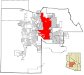
Ficheru:Maricopa County Incorporated and Planning areas Phoenix highlighted.svg

Tamañu de la vista previa PNG d'esti ficheru SVG: 694 × 599 pixels. Otres resoluciones: 278 × 240 pixels | 556 × 480 pixels | 889 × 768 pixels | 1185 × 1024 pixels | 2371 × 2048 pixels | 940 × 812 pixels.
Ficheru orixinal (ficheru SVG, 940 × 812 píxels nominales, tamañu de ficheru: 1,05 MB)
Historial del ficheru
Calca nuna fecha/hora pa ver el ficheru como taba daquella.
| Data/Hora | Miniatura | Dimensiones | Usuariu | Comentariu | |
|---|---|---|---|---|---|
| actual | 00:14 14 xnt 2022 |  | 940 × 812 (1,05 MB) | EmmaCoop | Cleaning up errors found on validator |
| 07:12 19 may 2011 |  | 940 × 812 (1,11 MB) | Ixnayonthetimmay | Uploading new version | |
| 04:35 30 ago 2008 |  | 900 × 800 (423 kB) | Ixnayonthetimmay | == Summary == {{Information |Description=This map shows the incorporated areas and unincorporated areas in Maricopa County, Arizona. [[:en:Paloma, Arizona|Pa | |
| 23:54 15 set 2007 |  | 900 × 800 (384 kB) | Ixnayonthetimmay | == Summary == {{Information |Description=This map shows the incorporated areas in Maricopa County, Arizona. It also shows the boundaries for the municipal planning areas. The [[:en:Fort | |
| 10:11 28 may 2007 |  | 900 × 780 (329 kB) | Ixnayonthetimmay | ||
| 00:55 22 may 2007 |  | 900 × 780 (318 kB) | Ixnayonthetimmay | ||
| 05:22 30 xin 2007 |  | 904 × 758 (189 kB) | Ixnayonthetimmay | {{Information |Description=This map shows the incorporated areas in Maricopa County, Arizona, highlighting Phoenix in red. It also shows the boundaries for the m |
Usu del ficheru
Nun hai páxines qu'usen esti ficheru.
Usu global del ficheru
Estes otres wikis usen esti ficheru:
- Usu en af.wikipedia.org
- Usu en bn.wikipedia.org
- Usu en br.wikipedia.org
- Usu en ceb.wikipedia.org
- Usu en en.wikipedia.org
- Usu en et.wikipedia.org
- Usu en fa.wikipedia.org
- Usu en fi.wikipedia.org
- Usu en fo.wikipedia.org
- Usu en he.wikipedia.org
- Usu en id.wikipedia.org
- Usu en ilo.wikipedia.org
- Usu en ja.wikipedia.org
- Usu en kn.wikipedia.org
- Usu en ko.wikipedia.org
- Usu en kw.wikipedia.org
- Usu en lad.wikipedia.org
- Usu en mi.wikipedia.org
- Usu en ml.wikipedia.org
- Usu en ms.wikipedia.org
- Usu en no.wikipedia.org
- Usu en pam.wikipedia.org
- Usu en pnb.wikipedia.org
- Usu en ro.wikipedia.org
- Usu en sco.wikipedia.org
- Usu en sk.wikipedia.org
- Usu en sl.wikipedia.org
- Usu en smn.wikipedia.org
- Usu en ta.wikipedia.org
- Usu en te.wikipedia.org
- Usu en tr.wikipedia.org
- Usu en ug.wikipedia.org
- Usu en ur.wikipedia.org
- Usu en vi.wikipedia.org
- Usu en zh-classical.wikipedia.org
- Usu en zh.wikipedia.org
