
Ficheru:Map of Kiribati CIA WFB.png
Nun ta disponible con mayor resolución.
Map_of_Kiribati_CIA_WFB.png (325 × 350 píxels, tamañu de ficheru: 9 kB, triba MIME: image/png)

|
Esta imagen debería volverse a crear como imágenes vectoriales SVG. Esto proporciona muchas ventajas, véase Commons:Media for cleanup (en inglés) para más información. Si ya hay una versión SVG de esta imagen disponible, por favor súbala a Commons. Tras subirla, reemplace esta plantilla con la plantilla
{{vector version available|nuevo nombre de imagen.svg}} en esta imagen. |
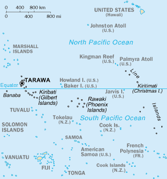
Resume
CIA-WF map of Kiribati
Llicencia
Esta imagen se encuentra en el dominio público ya que su contenido proviene de CIA World Factbook, un trabajo de la Agencia Central de Inteligencia de los Estados Unidos de América.
|
 |
Historial del ficheru
Calca nuna fecha/hora pa ver el ficheru como taba daquella.
| Data/Hora | Miniatura | Dimensiones | Usuariu | Comentariu | |
|---|---|---|---|---|---|
| actual | 15:35 17 set 2010 | | 325 × 350 (9 kB) | Ras67 | cropped |
| 09:15 27 mar 2005 |  | 330 × 354 (10 kB) | Wolfman~commonswiki | {{CIA-map}} |
Usu del ficheru
Nun hai páxines qu'usen esti ficheru.
Usu global del ficheru
Estes otres wikis usen esti ficheru:
- Usu en af.wikipedia.org
- Usu en avk.wikipedia.org
- Usu en azb.wikipedia.org
- Usu en ban.wikipedia.org
- Usu en bjn.wikipedia.org
- Usu en br.wikipedia.org
- Usu en bs.wikipedia.org
- Usu en ceb.wikipedia.org
- Usu en cs.wikipedia.org
- Usu en da.wikipedia.org
- Usu en de.wikivoyage.org
- Usu en en.wikipedia.org
- Howland Island
- Jarvis Island
- Line Islands
- Tabuaeran
- List of towns and villages in Kiribati
- Lists of hospitals in Oceania
- Talk:List of sovereign states and dependent territories in Oceania
- List of airports in Kiribati
- Wikipedia:Featured picture candidates/February-2007
- Wikipedia:Featured picture candidates/Kingman Reef
- Outline of Kiribati
- Wikipedia:Graphics Lab/Image workshop/Archive/Nov 2008
- Ministry of Line and Phoenix Islands Development
- Usu en en.wikisource.org
- Usu en en.wikiversity.org
- Usu en eo.wikipedia.org
- Usu en es.wikipedia.org
- Usu en et.wikipedia.org
- Usu en eu.wikipedia.org
- Usu en fa.wikipedia.org
- Usu en fi.wikipedia.org
Ver más usos globales d'esti ficheru.