
Ficheru:Malawi relief location map.jpg
Tamañu d'esta previsualización: 292 × 599 pixels. Otres resoluciones: 117 × 240 pixels | 234 × 480 pixels | 945 × 1937 pixels.
Ficheru orixinal (945 × 1937 píxels, tamañu de ficheru: 487 kB, triba MIME: image/jpeg)
Resume
| Descripción |
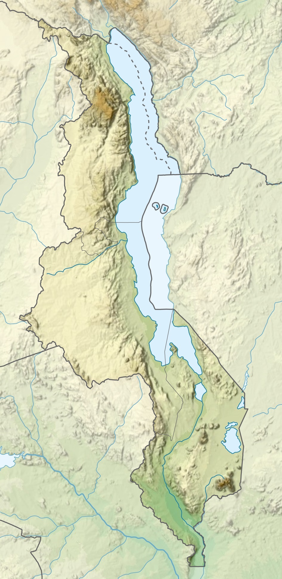
Español: Mapa de localización de Malaui
Deutsch: Positionskarte von Malawi
Quadratische Plattkarte. Geographische Begrenzung der Karte:
English: Location map of Malawi
Equirectangular projection. Geographic limits of the map:
|
| Data | |
| Fonte |
Este archivo deriva de: |
| Autor |
|
Llicencia
Yo, el titular de los drechos d'autor d'esta obra, la espublizo baxo les siguientes llicencies:

|
Autorízase la copia, distribución y/o cambéu d'esti documentu baxo los términos de la Llicencia de documentación llibre GNU, versión 1.2 o cualesquier otra que nel futuru espublice la Free Software Foundation; ensin seiciones invariables, testos de portada, nin testos de contraportada. S'inclúi una copia de la llicencia na seición titulada GNU Free Documentation License. |
Esti ficheru ta disponible baxo la llicencia Creative Commons Reconocimientu-Compartir igual 3.0 xenérica.
- Ye llibre:
- pa compartir – pa copiar, distribuir y comunicar públicamente la obra
- pa remezclar – p'adautar la obra
- Baxo les condiciones siguientes:
- reconocimientu – Tienes de dar el créitu apropiáu, apurrir un enllaz a la llicencia ya indicar si realizasti dalgún cambéu. Puedes faelo de cualquier mou razonable ,pero non de manera que suxera l'encontu del autor pa ti o pal usu que faigas.
- compartir igual – Si entemeces, tresformes o te bases nesti material, tienes de distribuir les tos contribuciones baxo la mesma llicencia o una compatible cola orixinal.
Pues seleicionar la llicencia que prefieras.
Historial del ficheru
Calca nuna fecha/hora pa ver el ficheru como taba daquella.
| Data/Hora | Miniatura | Dimensiones | Usuariu | Comentariu | |
|---|---|---|---|---|---|
| actual | 20:29 3 mar 2020 | | 945 × 1937 (487 kB) | Sémhur | Adding Tanzanian border claim (from https://www.nbs.go.tz/index.php/en/census-surveys/gis/385-2012-phc-shapefiles-level-one-and-two) |
| 19:26 20 xin 2015 |  | 945 × 1937 (499 kB) | Milenioscuro | User created page with UploadWizard |
Usu del ficheru
Les páxines siguientes usen esti ficheru:
Usu global del ficheru
Estes otres wikis usen esti ficheru:
- Usu en af.wikipedia.org
- Usu en avk.wikipedia.org
- Usu en az.wikipedia.org
- Usu en ban.wikipedia.org
- Usu en be.wikipedia.org
- Usu en bg.wikipedia.org
- Usu en bn.wikipedia.org
- Usu en da.wikipedia.org
- Usu en de.wikipedia.org
- Malawi
- Malawisee
- Mulanje (Bergmassiv)
- Kapichira-Wasserfälle
- Shire-Hochland
- Elephant Marsh
- Malombesee
- Chilwa-See
- Nyika-Plateau
- Chizumulu
- Nchenachena
- Nganda
- Salanjama
- Kasungu-Nationalpark
- Viphya Mountains
- Chongoni
- Vorlage:Positionskarte Malawi
- Wikipedia:Kartenwerkstatt/Positionskarten/Afrika
- Chisi Island
- Kaulime-See
- Likoma (Insel)
- Chiuta-See
- Tagebau Kayelekera
- Liwonde-Nationalpark
Ver más usos globales d'esti ficheru.