
Ficheru:Kronoberg, Open Street Map, September 2012.jpg
Nun ta disponible con mayor resolución.
Kronoberg,_Open_Street_Map,_September_2012.jpg (592 × 375 píxels, tamañu de ficheru: 279 kB, triba MIME: image/jpeg)
| Descripción |
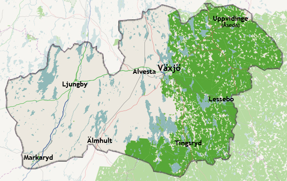
Svenska: En karta där Kronobergs län har lyfts fram tillsammans med dess kommuners centralorter. English: A map where Kronoberg County has been highlighted together with its municipal centres. The county is evenly forested, which may make the map colours seem somewhat confusing. |
|||
| Data | ||||
| Fonte | openstreetmap.org | |||
| Creador |
OpenStreetMap contributors |
|||
| Permisu (Cómo reutilizar esti ficheru) |
OpenStreetMap data is available under the Open Database License (details). Map tiles are licensed under the Creative Commons Attribution-ShareAlike 2.0 license (CC-BY-SA 2.0).
Este archivo se encuentra bajo la licencia Creative Commons Genérica de Atribución/Compartir-Igual 2.0.
|
|||
| Xeorreferenciador | Si nun ye apropiao, define warp_status = skip pa tapecer. |
| Annotations | This image is annotated: View the annotations at Commons |
Historial del ficheru
Calca nuna fecha/hora pa ver el ficheru como taba daquella.
| Data/Hora | Miniatura | Dimensiones | Usuariu | Comentariu | |
|---|---|---|---|---|---|
| actual | 20:11 13 set 2012 | | 592 × 375 (279 kB) | Christoffre | User created page with UploadWizard |
Usu del ficheru
La páxina siguiente usa esti ficheru:
Usu global del ficheru
Estes otres wikis usen esti ficheru:
- Usu en en.wikipedia.org
- Usu en fa.wikipedia.org
- Usu en ml.wikipedia.org
- Usu en se.wikipedia.org