
Ficheru:Kosovo location map.svg

Tamañu de la vista previa PNG d'esti ficheru SVG: 529 × 599 pixels. Otres resoluciones: 212 × 240 pixels | 424 × 480 pixels | 678 × 768 pixels | 904 × 1024 pixels | 1808 × 2048 pixels | 1015 × 1150 pixels.
Ficheru orixinal (ficheru SVG, 1015 × 1150 píxels nominales, tamañu de ficheru: 149 kB)

|
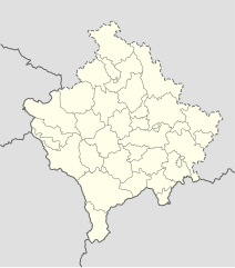
The boundaries on this map show the de facto situation. This is just one of several different views on the subject (see COM:NPOV). |
Resume
| Descripción |
Deutsch: Positionskarte des Kosovo
Quadratische Plattkarte, N-S-Streckung 140 %. Geographische Begrenzung der Karte:
English: Location map of Kosovo
Equirectangular projection, N/S stretching 140 %. Geographic limits of the map:
|
| Data | 01-08-2008 |
| Fonte | own work, using United States National Imagery and Mapping Agency data |
| Autor | NordNordWest |

|
Este mapa se ha hecho o mejorado en el Kartenwerkstatt (taller cartográfico) alemán. También puede proponer mapas para mejorar.
|
Llicencia
Yo, el titular de los drechos d'autor d'esta obra, la espublizo baxo les siguientes llicencies:

|
Autorízase la copia, distribución y/o cambéu d'esti documentu baxo los términos de la Llicencia de documentación llibre GNU, versión 1.2 o cualesquier otra que nel futuru espublice la Free Software Foundation; ensin seiciones invariables, testos de portada, nin testos de contraportada. S'inclúi una copia de la llicencia na seición titulada GNU Free Documentation License. |
Esti ficheru ta disponible baxo la llicencia Creative Commons Reconocimientu-Compartir igual 3.0 xenérica.
- Ye llibre:
- pa compartir – pa copiar, distribuir y comunicar públicamente la obra
- pa remezclar – p'adautar la obra
- Baxo les condiciones siguientes:
- reconocimientu – Tienes de dar el créitu apropiáu, apurrir un enllaz a la llicencia ya indicar si realizasti dalgún cambéu. Puedes faelo de cualquier mou razonable ,pero non de manera que suxera l'encontu del autor pa ti o pal usu que faigas.
- compartir igual – Si entemeces, tresformes o te bases nesti material, tienes de distribuir les tos contribuciones baxo la mesma llicencia o una compatible cola orixinal.
Pues seleicionar la llicencia que prefieras.
Historial del ficheru
Calca nuna fecha/hora pa ver el ficheru como taba daquella.
| Data/Hora | Miniatura | Dimensiones | Usuariu | Comentariu | |
|---|---|---|---|---|---|
| actual | 16:53 15 avi 2016 | | 1015 × 1150 (149 kB) | NordNordWest | Reverted to version as of 10:16, 13 December 2016 (UTC); yeah, strange, try official maps; and now stop changing this map without a discussion _before_ |
| 14:08 15 avi 2016 |  | 1015 × 1150 (103 kB) | AceDouble | Reverted to version as of 22:04, 12 December 2016 (UTC) Strange boundaries!? that's a funny one. Check it here> http://www.balgoc.org.tr/harita/kosova.jpg | |
| 10:16 13 avi 2016 |  | 1015 × 1150 (149 kB) | NordNordWest | Reverted to version as of 13:03, 23 November 2009 (UTC); no need for different colours, strange boundaries | |
| 22:04 12 avi 2016 |  | 1015 × 1150 (103 kB) | AceDouble | update | |
| 13:03 23 pay 2009 |  | 1015 × 1150 (149 kB) | NordNordWest | update | |
| 18:49 6 may 2009 |  | 1016 × 1150 (198 kB) | NordNordWest | more detailed | |
| 08:04 29 ago 2008 |  | 1016 × 1150 (78 kB) | NordNordWest | ||
| 17:41 1 ago 2008 |  | 339 × 383 (77 kB) | NordNordWest | {{Information |Description= {{de|Positionskarte des Kosovo}} Quadratische Plattkarte, N-S-Streckung 140 %. Geographische Begrenzung der Karte: * N: 43.4° N * S: 41.7° N * W: 19.8° O * O: 21.9° O {{en|Location map of [[:en:Kosovo|Kosovo] |
Usu del ficheru
Nun hai páxines qu'usen esti ficheru.
Usu global del ficheru
Estes otres wikis usen esti ficheru:
- Usu en de.wikipedia.org
- Usu en eo.wikipedia.org
- Usu en es.wikipedia.org
- Usu en fr.wikipedia.org
- Usu en mt.wikipedia.org
- Usu en pl.wikipedia.org
- Usu en ru.wikipedia.org
- Usu en sv.wikipedia.org
- Usu en uk.wikipedia.org