Ficheru:Kingdom of Mann and the Isles-es.svg

Contenido de la página no disponible en otros idiomas.
De Wikipedia

Ficheru orixinal(ficheru SVG, 1297 × 1362 píxels nominales, tamañu de ficheru: 207 kB)

Esti ficheru ye de Wikimedia Commons y puen usalu otros proyeutos. La descripción de la páxina de descripción del ficheru s'amuesa darréu.

Resume

Descripción
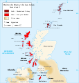
English: Map of the kingdom of Mann and the Isles, nearly the end of eleventh century.
 
Norðr : Shetland and Orkney
 
Sodor : Man and Hebrides
Español: Reino de Man y de las Islas a finales del siglo XI.
 
Norðr : Shetland y las Orcadas
 
Sodor : Man y las Hébridas
Français : Carte du royaume de Man et des Îles, vers la fin du onzième siècle.
 
Norðr : Shetland et Orcades
 
Sodor : Man et Hebrides
Data (UTC)
Fonte Este archivo deriva de: Kingdom of Mann and the Isles-en.svg
Autor


Esta ye una imaxe retocada, lo que significa que foi modificada dixitalmente de la so versión orixinal. Modificaciones: translated into Spanish. La orixinal pue vese equí: Kingdom of Mann and the Isles-en.svg. Modificationes feches por Rowanwindwhistler.

Llicencia

w:es:Creative Commons
reconocimientu compartir igual
Esti ficheru ta disponible baxo la llicencia Creative Commons Reconocimientu-Compartir igual 3.0 xenérica.
Ye llibre:
  • pa compartir – pa copiar, distribuir y comunicar públicamente la obra
  • pa remezclar – p'adautar la obra
Baxo les condiciones siguientes:
  • reconocimientu – Tienes de dar el créitu apropiáu, apurrir un enllaz a la llicencia ya indicar si realizasti dalgún cambéu. Puedes faelo de cualquier mou razonable ,pero non de manera que suxera l'encontu del autor pa ti o pal usu que faigas.
  • compartir igual – Si entemeces, tresformes o te bases nesti material, tienes de distribuir les tos contribuciones baxo la mesma llicencia o una compatible cola orixinal.

Rexistru de xubíes orixinal

This image is a derivative work of the following images:

  • File:Kingdom_of_Mann_and_the_Isles-en.svg licensed with Cc-by-sa-3.0,2.5,2.0,1.0, FAL
    • 2007-10-15T10:06:06Z Sémhur 1297x1362 (213177 Bytes) {{Information |Description=Map of the kingdom of Mann and the Isles, nearly the end of eleventh century |Source=Own work, from : * [[:Image:British Isles.svg|Map of British Isles]] * [[:Image:Mormaerdoms.png|Map of kingdoms o

Uploaded with derivativeFX

Pies

Añade una explicación corta acerca de lo que representa este archivo

Elementos representados en este archivo

representa a

Historial del ficheru

Calca nuna fecha/hora pa ver el ficheru como taba daquella.

Data/HoraMiniaturaDimensionesUsuariuComentariu
actual18:59 5 may 2016Miniatura de la versión a fecha de 18:59 5 may 20161297 × 1362 (207 kB)Rowanwindwhistlerhttps://en.wikipedia.org/wiki/Wikipedia:WikiProject_Maps/Conventions
06:28 6 xnt 2013Miniatura de la versión a fecha de 06:28 6 xnt 20131297 × 1362 (207 kB)RowanwindwhistlerSome text had not been translated
06:26 6 xnt 2013Miniatura de la versión a fecha de 06:26 6 xnt 20131297 × 1362 (207 kB)Rowanwindwhistler== {{int:filedesc}} == {{Information |Description={{Multilingual description |en= Map of the kingdom of Mann and the Isles, nearly the end of eleventh century. {{legend|#980101|Norðr : Shetland and Orkney}} {{lege...

La páxina siguiente usa esti ficheru:

Usu global del ficheru

Metadatos