Ficheru:ISS-38 Southern Patagonian Ice Field.jpg

Contenido de la página no disponible en otros idiomas.
De Wikipedia

Ficheru orixinal(4256 × 2832 píxels, tamañu de ficheru: 1,2 MB, triba MIME: image/jpeg)

Esti ficheru ye de Wikimedia Commons y puen usalu otros proyeutos. La descripción de la páxina de descripción del ficheru s'amuesa darréu.

Resume

Descripción
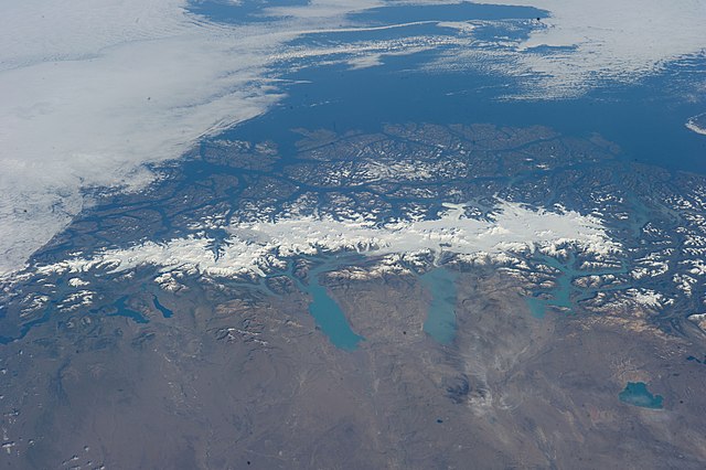
English: This grand panorama of the Southern Patagonia Icefield (center) was imaged by an Expedition 38 crew member on the International Space Station on one of the rare clear days in the southern Andes Mountains.
  • With an area of 13,000 square kilometers, the icefield is the largest temperate ice sheet in the Southern Hemisphere. Storms that swirl into the region from the southern Pacific Ocean (top) bring rain and snow (equivalent to a total of 2-11 meters of rainfall per year) resulting in the buildup of the ice sheet shown here (center).
  • During the ice ages the glaciers were far larger. Geologists now know that ice tongues extended far onto the plains in the foreground, completely filling the great Patagonian lakes on repeated occasions. Similarly, ice tongues extended into the dense network of fjords (arms of the sea) on the Pacific side of the icefield. Ice tongues today appear tiny compared to the view that an "ice age" astronaut would have seen.
  • A study of the surface topography of sixty-three glaciers, based on Shuttle Radar Topography Mission (SRTM) data, compared data from 2000 to data from studies going back about 30 years (1968-1975). Many glacier tongues showed significant annual "retreat" of their ice fronts, a familiar signal of climate change. The study also revealed that the almost invisible loss by glacier thinning is far more significant in explaining ice loss. The researchers concluded that volume loss by frontal collapse is 4-10 times smaller than that caused by thinning. Scaled over the entire icefield, including frontal loss (so-called calving when ice masses collapse into the lakes), it was calculated that 13.5 cubic kilometers of ice was lost each year over the study period.
  • This number becomes more meaningful compared with the rate measured in the last five years of the study (1995-2000), when the rate increased almost threefold, averaging 38.7 cubic kilometers per year. Extrapolating results from the low altitude glacier tongues implies that the high plateau ice on the spine of the Andes is thinning as well. In the decade since this study the often-imaged Upsala Glacier has retreated a further three kilometers, as shown recently in images taken by crew members aboard the space station. Glacier Pio X, named for Pope Pius X, is the only large glacier that is growing in length.
Data
Fonte https://www.flickr.com/photos/nasa2explore/12905018565/
Autor NASA
Este archivo fue catalogado por
Johnson Space Center
de la Administración Nacional de Aeronáutica y del Espacio (NASA) de los Estados Unidos de Américabajo el identificador de foto: ISS038-E-047324.

Esta etiqueta no indica el estado de los derechos de autor del trabajo adjunto. Se requiere una etiqueta de derechos de autor normal. Para más información vea Commons:Sobre las licencias.
Otros idiomas:

Llicencia

Public domain
"The Gateway to Astronaut Photography of Earth". Imagen cortesía de Image Science & Analysis Laboratory, NASA Johnson Space Center.
Fuente de la foto: ISS038-E-047324.

العربيَّة | Deutsch | English | español | français | italiano | kurdî | македонски | മലയാളം | português | sicilianu | +/−

Pies

Añade una explicación corta acerca de lo que representa este archivo
Southern Patagonia Icefield, (L-R) south to north, taken from the International Space Station

Elementos representados en este archivo

representa a

0,005 segundu

número f español

18

distancia focal español

65 milímetru

200

tipo de archivo español

image/jpeg

Historial del ficheru

Calca nuna fecha/hora pa ver el ficheru como taba daquella.

Data/HoraMiniaturaDimensionesUsuariuComentariu
actual01:47 27 xun 2014Miniatura de la versión a fecha de 01:47 27 xun 20144256 × 2832 (1,2 MB)Ras67== {{int:filedesc}} == {{Information |Description={{en|1=This grand panorama of the Southern Patagonia Icefield (center) was imaged by an Expedition 38 crew member on the International Space Station on one of the rare clear days in the southern Andes M...

La páxina siguiente usa esti ficheru:

Usu global del ficheru

Estes otres wikis usen esti ficheru:

Metadatos