
Ficheru:Hammurabi's Babylonia Locator Map 1.svg

Tamañu de la vista previa PNG d'esti ficheru SVG: 671 × 600 pixels. Otres resoluciones: 269 × 240 pixels | 537 × 480 pixels | 859 × 768 pixels | 1146 × 1024 pixels | 2291 × 2048 pixels | 744 × 665 pixels.
Ficheru orixinal (ficheru SVG, 744 × 665 píxels nominales, tamañu de ficheru: 154 kB)
Resume
| Descripción |
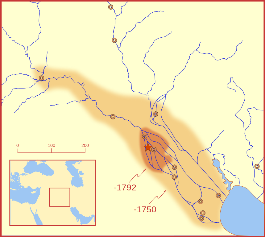
A locator map of Hammurabi's Babylonia, showing the Babylonian territory upon his ascension in 1792 BC and upon his death in 1750 BC. The river courses and coastline are those of that time period -- in general, they are not the modern rivers or coastlines. This is a Mercator projection, with north in its usual position. There is some question to what degree the cities of Nineveh, Tuttul, and Assur were under Babylonian authority. While in his introduction to his code of laws, Hammurabi claims lordship over these cities, Roaf does not include any of these in his map, upon which this map is based, and Chevalas states that "Assur and Nineveh were held for a very few years" (p. 155). Therefore, I have not included them as under Hammurabi's control in 1750 BC. |
| Data | |
| Fonte | Trabayu propiu |
| Autor | MapMaster |
| Otres versiones |
[]
|


Other versions
References
- Bjorklund, Oddvar; Holmboe, Haakon; Rohr, Anders (1970) Historical Atlas of the World, Barnes & Noble, NY, SBN: 389-00253-4.
- Chavalas, Mark W.; K. Lawson Younger (2003) Mesopotamia and the Bible, Continuum International Publishing Group, ISBN 978-0567082312.
- Hammond World Atlas Corporation (2007) Historical World Atlas, ISBN 9-780843-71391-6
- Roaf, M. (1990) Cultural Atlas of Mesopotamia and the ancient Near East, Oxford: Facts on File. (In general, the basis for the ancient river courses and ancient coastline).
- Van De Mieroop, Marc (2005). King Hammurabi of Babylon: A Biography. Blackwell Publishing. ISBN 1405126604
Llicencia
Yo, el titular de los drechos d'autor d'esta obra, la espublizo baxo les siguientes llicencies:

|
Autorízase la copia, distribución y/o cambéu d'esti documentu baxo los términos de la Llicencia de documentación llibre GNU, versión 1.2 o cualesquier otra que nel futuru espublice la Free Software Foundation; ensin seiciones invariables, testos de portada, nin testos de contraportada. S'inclúi una copia de la llicencia na seición titulada GNU Free Documentation License. |
This file is licensed under the Creative Commons Attribution-Share Alike 4.0 International, 3.0 Unported, 2.5 Generic, 2.0 Generic and 1.0 Generic license.
- Ye llibre:
- pa compartir – pa copiar, distribuir y comunicar públicamente la obra
- pa remezclar – p'adautar la obra
- Baxo les condiciones siguientes:
- reconocimientu – Tienes de dar el créitu apropiáu, apurrir un enllaz a la llicencia ya indicar si realizasti dalgún cambéu. Puedes faelo de cualquier mou razonable ,pero non de manera que suxera l'encontu del autor pa ti o pal usu que faigas.
- compartir igual – Si entemeces, tresformes o te bases nesti material, tienes de distribuir les tos contribuciones baxo la mesma llicencia o una compatible cola orixinal.
Pues seleicionar la llicencia que prefieras.
Historial del ficheru
Calca nuna fecha/hora pa ver el ficheru como taba daquella.
| Data/Hora | Miniatura | Dimensiones | Usuariu | Comentariu | |
|---|---|---|---|---|---|
| actual | 03:26 21 feb 2008 | | 744 × 665 (154 kB) | MapMaster | "blurred" the territory outlines |
| 23:22 20 feb 2008 |  | 744 × 665 (149 kB) | MapMaster | Changes based on a review of ''Mesopotamia and the Bible'' | |
| 22:10 20 feb 2008 |  | 744 × 665 (151 kB) | MapMaster | Minor edits | |
| 03:03 19 feb 2008 |  | 744 × 665 (150 kB) | MapMaster | Once more, with feeling | |
| 02:09 19 feb 2008 |  | 744 × 665 (151 kB) | MapMaster | earlier upload would not render | |
| 02:01 19 feb 2008 |  | 332 × 292 (333 kB) | MapMaster | {{Information |Description=A locator map of Hammurabi's Babylonia, showing the Babylonian territory upon his ascension in 1792 BC and upon his death in 1750 BC. The river courses and coastline are those of that time period -- in general, they are not the |
Usu del ficheru
Nun hai páxines qu'usen esti ficheru.
Usu global del ficheru
Estes otres wikis usen esti ficheru:
- Usu en bg.wikipedia.org
- Usu en bs.wikipedia.org
- Usu en cs.wikipedia.org
- Usu en da.wikipedia.org
- Usu en el.wikipedia.org
- Usu en eo.wikipedia.org
- Usu en et.wikipedia.org
- Usu en fi.wikipedia.org
- Usu en fr.wikipedia.org
- Usu en gl.wikipedia.org
- Usu en he.wikipedia.org
- Usu en hr.wikipedia.org
- Usu en hu.wikipedia.org
- Usu en id.wikipedia.org
- Usu en it.wikipedia.org
- Usu en ja.wikipedia.org
- Usu en jv.wikipedia.org
- Usu en lt.wikipedia.org
- Usu en lv.wikipedia.org
- Usu en nl.wikipedia.org
- Usu en no.wikipedia.org
- Usu en pl.wikipedia.org
- Usu en pt.wikipedia.org
- Usu en ro.wikipedia.org
- Usu en ru.wikipedia.org
- Usu en sh.wikipedia.org
- Usu en sl.wikipedia.org
- Usu en sq.wikipedia.org
- Usu en sv.wikipedia.org
- Usu en sw.wikipedia.org
- Usu en tr.wikipedia.org