
Ficheru:Great Lakes and St. Lawrence Seaway map 1959.png
Tamañu d'esta previsualización: 800 × 482 pixels. Otres resoluciones: 320 × 193 pixels | 640 × 386 pixels | 1024 × 617 pixels | 1280 × 771 pixels | 2627 × 1583 pixels.
Ficheru orixinal (2627 × 1583 píxels, tamañu de ficheru: 3,63 MB, triba MIME: image/png)
Resume
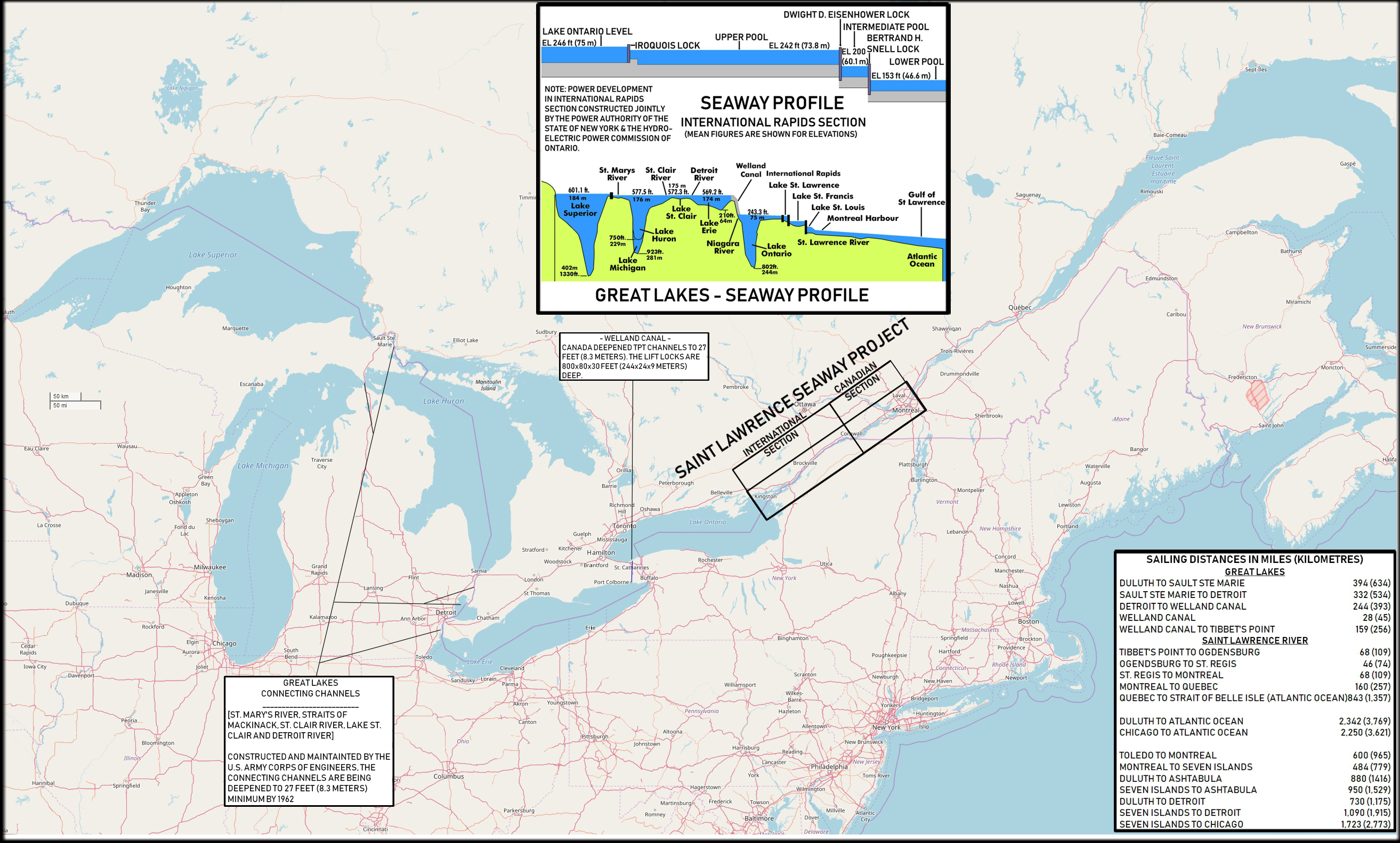
| Descripción | Map of the North American Great Lakes and the St. Lawrence Seaway. |
| Data | 2018-02-25, original map from 1959 |
| Fonte | Based on: U.S. Navy All Hands magazine September 1959, p. 9. Also used and partly incorporated were File:Great Lakes 2.PNG and File:Water transport lock horizontal and sectional drawing.png. Map from openstreetmap.org. |
| Autor | Cobatfor |
Llicencia
Yo, el titular de los drechos d'autor d'esta obra, la espublizo baxo les siguientes llicencies:
Esti ficheru ta disponible baxo la llicencia Creative Commons Reconocimientu-Compartir igual 3.0 xenérica.
- Ye llibre:
- pa compartir – pa copiar, distribuir y comunicar públicamente la obra
- pa remezclar – p'adautar la obra
- Baxo les condiciones siguientes:
- reconocimientu – Tienes de dar el créitu apropiáu, apurrir un enllaz a la llicencia ya indicar si realizasti dalgún cambéu. Puedes faelo de cualquier mou razonable ,pero non de manera que suxera l'encontu del autor pa ti o pal usu que faigas.
- compartir igual – Si entemeces, tresformes o te bases nesti material, tienes de distribuir les tos contribuciones baxo la mesma llicencia o una compatible cola orixinal.

|
Autorízase la copia, distribución y/o cambéu d'esti documentu baxo los términos de la Llicencia de documentación llibre GNU, versión 1.2 o cualesquier otra que nel futuru espublice la Free Software Foundation; ensin seiciones invariables, testos de portada, nin testos de contraportada. S'inclúi una copia de la llicencia na seición titulada GNU Free Documentation License. |
Pues seleicionar la llicencia que prefieras.
Historial del ficheru
Calca nuna fecha/hora pa ver el ficheru como taba daquella.
| Data/Hora | Miniatura | Dimensiones | Usuariu | Comentariu | |
|---|---|---|---|---|---|
| actual | 17:18 25 feb 2018 | | 2627 × 1583 (3,63 MB) | Cobatfor | self-made version, metric measurements added |
| 10:22 10 may 2014 | Ensin miniatura | 1423 × 944 (702 kB) | Cobatfor | == {{int:filedesc}} == {{Information |Description=Map of the North American Great Lakes and the St. Lawrence Seaway. |Source=[http://www.navy.mil/ah_online/department_arch.html U.S. Navy All Hands magazine] [http://www.navy.mil/ah_online/archpdf/ah1959... |
Usu del ficheru
La páxina siguiente usa esti ficheru:
Usu global del ficheru
Estes otres wikis usen esti ficheru:
- Usu en en.wikipedia.org
- Usu en es.wikipedia.org
- Usu en ja.wikipedia.org
- Usu en nl.wikipedia.org