
Ficheru:Geological time spiral.png

Ficheru orixinal (2424 × 2145 píxels, tamañu de ficheru: 1,86 MB, triba MIME: image/png)
Esta imagen ha sido seleccionada como la Imagen del día el 11 de junio de 2009. Fue descrita como sigue: Español: Diagrama de la escala de tiempo geológica Otros idiomas:
Bahasa Indonesia: Diagram skala waktu geologi yang berbentuk spiral Čeština: Schématické znázornění geologické časové škály Deutsch: Visuelle Darstellung der Erdzeitalter als Zeitspirale mit englischer Beschriftung (eine deutsche Version der Grafik ist derzeit nicht vorhanden) English: A diagram of the geological time scale Español: Diagrama de la escala de tiempo geológica Français : Diagramme de l'échelle des temps géologiques. Italiano: Diagramma della scala dei tempi geologici. Magyar: A geológiai időskála szemléltetése Nederlands: Engelstalige visuele presentatie van de geologische tijdschaal in de vorm van een spiraal Polski: Diagram przedstawiający skalę czasu geologicznego. Română: Diagramă a istoriei geologice a Pământului Slovenščina: Diagram geoloških dob (napisi v angleščini) Македонски: Приказ на геолошките периоди मराठी: विविध भूशास्त्रीय काळ दाखवणारे चित्र 한국어: 지질학적 연대표. 日本語: ら旋状の地質学年表 中文: 地质学时标图 中文(繁體): 地質學時標圖 עברית : דיאגרמה של סקאלת זמן גיאולוגי |
This image was selected as picture of the day on Vietnamese Wikipedia.
|
|

Resume
| Descripción |
English: A diagram of the geological time scale
Esperanto: Diagramo montranta la geologian temposkalon
Français : Diagramme montrant l'échelle des temps géologiques. |
| Data | setiembre de 2008 (Version 1.1) |
| Fonte | Graham, Joseph, Newman, William, and Stacy, John, 2008, The geologic time spiral—A path to the past (ver. 1.1): U.S. Geological Survey General Information Product 58, poster, 1 sheet. Available online at http://pubs.usgs.gov/gip/2008/58/ |
| Autor | United States Geological Survey |
| Otres versiones |
Este archivo deriva de: Geologica time USGS.png: |
.jpg)
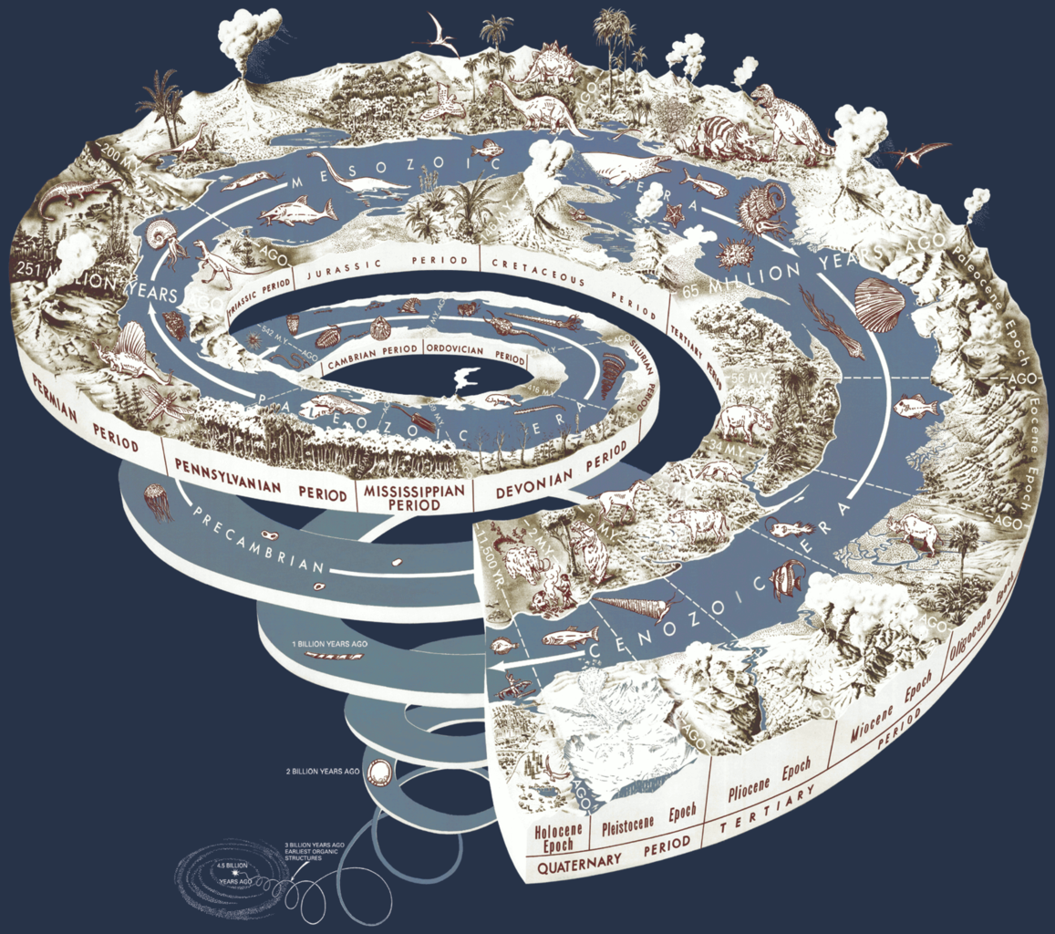
Caption
Original source: http://pubs.usgs.gov/gip/2008/58/geotimespiral_text.pdf
The Earth is very old—4.5 billion years or more according to scientific estimates. Most of the evidence for an ancient Earth is contained in the rocks that form the Earth's crust. The rock layers themselves—like pages in a long and complicated history—record the events of the past, and buried within them are the remains of life—the plants and animals that evolved from organic structures that existed 3 billion years ago.
Also contained in rocks once molten are radioactive elements whose isotopes provide Earth with an atomic clock. Within these rocks, "parent" isotopes decay at a predictable rate to form "daughter" isotopes. By determining the relative amounts of parent and daughter isotopes, the age of these rocks can be calculated. Thus, the scientific evidence from rock layers, from fossils, and from the ages of rocks as measured by atomic clocks attests to a very old Earth.
See USGS Fact Sheet 2007-3015 at http://pubs.usgs.gov/fs/2007/3015/ for ages of geologic time periods. Ages in the spiral have been rounded from the age estimates in the Fact Sheet. B.Y., billion years; M.Y., million years. For more information, see the booklet on Geologic Time at http://pubs.usgs.gov/gip/geotime/.
Llicencia
Esta imagen está en el dominio público, ya que contiene materiales que originalmente vinieron del Servicio Geológico de los Estados Unidos de América, una agencia del Departamento del Interior. Para obtener más información, consulte la política oficial de derechos de los USGS.
|
Historial del ficheru
Calca nuna fecha/hora pa ver el ficheru como taba daquella.
| Data/Hora | Miniatura | Dimensiones | Usuariu | Comentariu | |
|---|---|---|---|---|---|
| actual | 00:05 6 xnt 2012 | | 2424 × 2145 (1,86 MB) | JohnnyMrNinja | Same image reduced from 6MB to 1.85MB. Removed unused transparency layer, indexed colors and increased compression, using en:GIMP. |
| 22:04 19 mar 2009 |  | 2424 × 2145 (6,03 MB) | Notyourbroom | Recropped my own version to have borders similar to the original upload. | |
| 22:00 19 mar 2009 |  | 2599 × 2458 (6,06 MB) | Notyourbroom | Much higher-res version (2599x2458@300DPI) cropped from the original PDF source. | |
| 22:51 29 avi 2008 |  | 1617 × 1454 (752 kB) | Mwtoews | {{Information |Description={{en|1=...}} |Source=USGS |Author=USGS |Date= |Permission= |other_versions= }} <!--{{ImageUpload|full}}--> |
Usu del ficheru
La páxina siguiente usa esti ficheru:
Usu global del ficheru
Estes otres wikis usen esti ficheru:
- Usu en af.wikipedia.org
- Usu en ar.wikipedia.org
- قالب:بذرة زمن جيولوجي
- العصر الباليوسيني
- إحاثة (علم)
- تاريخ الأرض الجيولوجي
- بحر تيثس
- الثلاثي الأوسط
- الثلاثي المبكر
- عصر البنسلفاني
- عصر المسيسيبي
- فترة كريبتية
- جيولوجيا تاريخية
- دهر (جيولوجيا)
- عصر (جيولوجيا)
- الحقبة السحيقة الحديثة
- الحقبة السحيقة المبكرة
- الحقبة السحيقة الأولى
- عصر السيدري
- عصر الرياسي
- عصر الأوروسيري
- عصر الستاثري
- عصر الكالمي
- عصر الستني
- عصر التوني
- الوينلوك (السيلوري)
- الشينوودي
- الهوميري
- الغورستي
- الإفلي
- الفراسني
- الفالانجيني
- الأبريسيني
- البريابوني
- الروبيلي
- الخاتي
- الأكويتاني
- اللانغي
- التورتوني
- الجيلاسي
- الكالابري
- التشيباني
- البليستوسيني المتأخر
- ما قبل البوريال
- البوريال
- تحت الأطلنطي
- فترة (جيولوجيا)
- حين (جيولوجيا)
- مستخدم:ASammour/بذرة-بوابة
- تقلب طول النهار
Ver más usos globales d'esti ficheru.