
Ficheru:Fukushima I NPP 1975 medium crop rotated labeled.jpg

Tamañu d'esta previsualización: 300 × 600 pixels. Otres resoluciones: 120 × 240 pixels | 240 × 480 pixels.
Ficheru orixinal (800 × 1600 píxels, tamañu de ficheru: 248 kB, triba MIME: image/jpeg)
Resume
| Descripción |
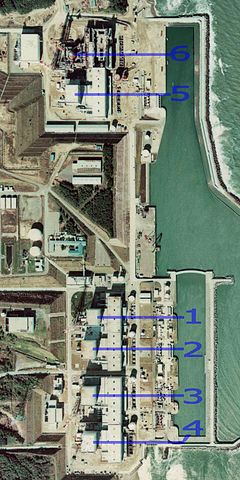
English: Fukushima I Nuclear Power Plant. Medium crop showing reactors labeled 1 to 5 and site for reactor 6. North is up.
日本語: 福島第一原子力発電所。 |
| Data | |
| Fonte | http://w3land.mlit.go.jp/cgi-bin/WebGIS2/WC_AirPhoto.cgi?IT=p&DT=n&PFN=CTO-75-30&PCN=C29B&IDX=21 |
| Autor | Ministry of Land, Infrastructure, Transport and Tourism |
| Otres versiones |
|
| Posición de la cámara | | Ubicación de esta y otras imágenes en: OpenStreetMap |
|---|
Llicencia

|
El titular de los drechos d'autor d'esti ficheru, the Ministry of Land, Infrastructure, Transport and Tourism of Japan, permite a cualesquier persona usalu pa cualesquier propósitu, mentanto se-y reconoza al titular d'esos drechos de mou afayadizu. La redistribución, les obres derivaes, l'usu comercial y tolos demás usos tan permitíos. |
Reconocimientu:
Copyright © National Land Image Information (Color Aerial Photographs), Ministry of Land, Infrastructure, Transport and Tourism
|
 |
This image is copyrighted by the Ministry of Land, Infrastructure, Transport and Tourism of Japan. For terms of use, see the stipulation to use of National Land Information (in Japanese) and message from MLIT (in Japanese and English). When you display this image on an article, include the following phrase in the description: "Made based on National Land Image Information (Color Aerial Photographs), Ministry of Land, Infrastructure, Transport and Tourism".
|
Historial del ficheru
Calca nuna fecha/hora pa ver el ficheru como taba daquella.
| Data/Hora | Miniatura | Dimensiones | Usuariu | Comentariu | |
|---|---|---|---|---|---|
| actual | 23:54 15 mar 2011 | | 800 × 1600 (248 kB) | 84user | =={{int:filedesc}}== {{Information |Description={{en|1=Fukushima I Nuclear Power Plant. Medium crop showing reactors labeled 1 to 5 and site for reactor 6. North is up.}} {{ja|1=[[:ja:福島第一原子力発電所| |
Usu del ficheru
La páxina siguiente usa esti ficheru:
Usu global del ficheru
Estes otres wikis usen esti ficheru:
- Usu en ar.wikipedia.org
- Usu en be-tarask.wikipedia.org
- Usu en ca.wikipedia.org
- Usu en cs.wikipedia.org
- Usu en cv.wikipedia.org
- Usu en de.wikipedia.org
- Usu en de.wikinews.org
- Usu en en.wikipedia.org
- Usu en en.wikibooks.org
- Usu en es.wikipedia.org
- Usu en fi.wikipedia.org
- Usu en fr.wikipedia.org
- Usu en gl.wikipedia.org
- Usu en he.wikipedia.org
- Usu en hi.wikipedia.org
- Usu en ja.wikipedia.org
- Usu en ko.wikipedia.org
- Usu en ko.wikinews.org
- Usu en ms.wikipedia.org
- Usu en nl.wikipedia.org
- Usu en pl.wikipedia.org
- Usu en pt.wikipedia.org
- Usu en rm.wikipedia.org
- Usu en ru.wikipedia.org
- Usu en sq.wikinews.org
- Usu en ta.wikipedia.org
- Usu en th.wikipedia.org
- Usu en zh.wikipedia.org