
Ficheru:French Mandate for Syria and the Lebanon map en.svg

Tamañu de la vista previa PNG d'esti ficheru SVG: 725 × 599 pixels. Otres resoluciones: 290 × 240 pixels | 581 × 480 pixels | 929 × 768 pixels | 1239 × 1024 pixels | 2478 × 2048 pixels | 922 × 762 pixels.
Ficheru orixinal (ficheru SVG, 922 × 762 píxels nominales, tamañu de ficheru: 245 kB)
Resume
| Descripción |
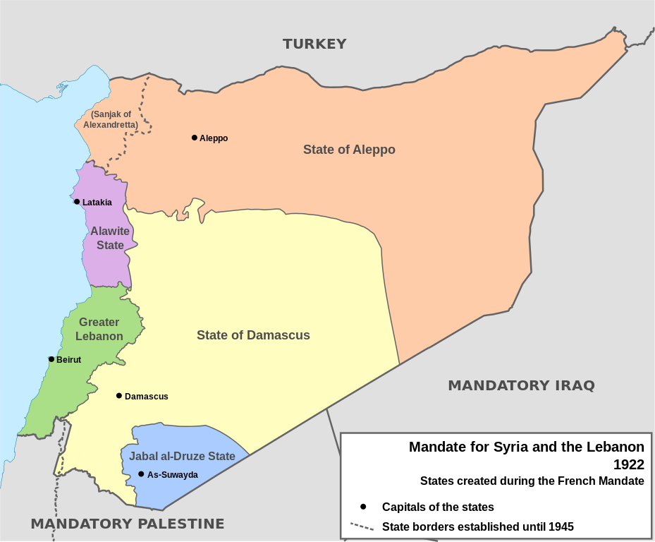
English: Map of French Mandate for Syria and the Lebanon and the states created in 1922, in English. Sources:
|
| Data | |
| Fonte | Trabayu propiu, based on File:Syria, administrative divisions - de - colored.svg |
| Autor | Don-kun, TUBS, NordNordWest |
| Otres versiones |
[]
|


Llicencia
Yo, el titular de los drechos d'autor d'esta obra, la espublizo baxo les siguientes llicencies:

|
Autorízase la copia, distribución y/o cambéu d'esti documentu baxo los términos de la Llicencia de documentación llibre GNU, versión 1.2 o cualesquier otra que nel futuru espublice la Free Software Foundation; ensin seiciones invariables, testos de portada, nin testos de contraportada. S'inclúi una copia de la llicencia na seición titulada GNU Free Documentation License. |
Este archivo se encuentra bajo la licencia Creative Commons Atribución 3.0 Unported.
- Ye llibre:
- pa compartir – pa copiar, distribuir y comunicar públicamente la obra
- pa remezclar – p'adautar la obra
- Baxo les condiciones siguientes:
- reconocimientu – Tienes de dar el créitu apropiáu, apurrir un enllaz a la llicencia ya indicar si realizasti dalgún cambéu. Puedes faelo de cualquier mou razonable ,pero non de manera que suxera l'encontu del autor pa ti o pal usu que faigas.
Pues seleicionar la llicencia que prefieras.
Historial del ficheru
Calca nuna fecha/hora pa ver el ficheru como taba daquella.
| Data/Hora | Miniatura | Dimensiones | Usuariu | Comentariu | |
|---|---|---|---|---|---|
| actual | 16:05 4 feb 2013 | | 922 × 762 (245 kB) | AnonMoos | Change "Libanon" to "Lebanon" |
| 15:33 4 feb 2013 |  | 922 × 762 (250 kB) | Don-kun | fix border to palestine, source: http://en.wikisource.org/wiki/Franco-British_Convention_on_Certain_Points_Connected_with_the_Mandates_for_Syria_and_the_Lebanon,_Palestine_and_Mesopotamia | |
| 18:43 30 xin 2013 |  | 922 × 762 (248 kB) | Don-kun | minus ahistorical lakes (and so all waterbodies) | |
| 21:44 26 xin 2013 |  | 922 × 762 (282 kB) | Don-kun | {{Information |Description ={{en|1=Map of French Mandate for Syria and the Lebanon and the states created in 1922, in English.}} |Source ={{own}}, based on File:Syria, administrative divisions - de - colored.svg |Author =[[User:... |
Usu del ficheru
La páxina siguiente usa esti ficheru:
Usu global del ficheru
Estes otres wikis usen esti ficheru:
- Usu en af.wikipedia.org
- Usu en ar.wikipedia.org
- Usu en azb.wikipedia.org
- Usu en az.wikipedia.org
- Usu en be.wikipedia.org
- Usu en bg.wikipedia.org
- Usu en bn.wikipedia.org
- Usu en ca.wikipedia.org
- Usu en cs.wikipedia.org
- Usu en de.wikipedia.org
- Usu en el.wikipedia.org
- Usu en en.wikipedia.org
Ver más usos globales d'esti ficheru.