
Ficheru:Flotillagazamapa.svg

Tamañu de la vista previa PNG d'esti ficheru SVG: 783 × 600 pixels. Otres resoluciones: 314 × 240 pixels | 627 × 480 pixels | 1003 × 768 pixels | 1280 × 980 pixels | 2560 × 1960 pixels | 1148 × 879 pixels.
Ficheru orixinal (ficheru SVG, 1148 × 879 píxels nominales, tamañu de ficheru: 815 kB)
Resume
| Descripción |
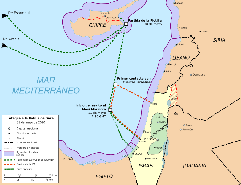
English: Freedom Flotilla incident. 31 may 2010.
Cartographic base from Open Street Maps (heavily modified) Flotilla route points from Freegaza.org (under CC by-sa)Español: Ataque a la Flotilla Libertad (ó Flotilla de Gaza) el 31 de mayo de 2010.
Base cartográfica de Open Street Maps (muy modificada) Puntos de la ruta de la Flotilla Freegaza.org (bajo licencia CC by-sa) |
| Data | |
| Fonte | Trabayu propiu |
| Autor | Montgomery |
| Otres versiones |
Derivative works of this file: Gaza flotilla raid map.svg  |
Geographic limits of the map:
- N 35.66° N
- S 30.47° N
- W 29.92° E
- E 38.01° E
Scale (full extent image) 1:3.500.000
Llicencia
Yo, el titular de los drechos d'autor d'esta obra, la espublizo baxo les siguientes llicencies:

|
Autorízase la copia, distribución y/o cambéu d'esti documentu baxo los términos de la Llicencia de documentación llibre GNU, versión 1.2 o cualesquier otra que nel futuru espublice la Free Software Foundation; ensin seiciones invariables, testos de portada, nin testos de contraportada. S'inclúi una copia de la llicencia na seición titulada GNU Free Documentation License. |
This file is licensed under the Creative Commons Attribution-Share Alike 4.0 International, 3.0 Unported, 2.5 Generic, 2.0 Generic and 1.0 Generic license.
- Ye llibre:
- pa compartir – pa copiar, distribuir y comunicar públicamente la obra
- pa remezclar – p'adautar la obra
- Baxo les condiciones siguientes:
- reconocimientu – Tienes de dar el créitu apropiáu, apurrir un enllaz a la llicencia ya indicar si realizasti dalgún cambéu. Puedes faelo de cualquier mou razonable ,pero non de manera que suxera l'encontu del autor pa ti o pal usu que faigas.
- compartir igual – Si entemeces, tresformes o te bases nesti material, tienes de distribuir les tos contribuciones baxo la mesma llicencia o una compatible cola orixinal.
Pues seleicionar la llicencia que prefieras.
Historial del ficheru
Calca nuna fecha/hora pa ver el ficheru como taba daquella.
| Data/Hora | Miniatura | Dimensiones | Usuariu | Comentariu | |
|---|---|---|---|---|---|
| actual | 08:36 14 pay 2012 | | 1148 × 879 (815 kB) | Kalgaron | FALSE, unless you can supply sources that indicate the flotilla was not headed for Gaza |
| 22:28 30 xun 2011 |  | 1148 × 879 (818 kB) | Randam | Correction according to flotilla site | |
| 22:47 15 xun 2010 |  | 1148 × 879 (815 kB) | Montgomery | Golan Heights (Altos del Golán) painted with stripes. Hour adjust. | |
| 13:59 10 xun 2010 |  | 1148 × 879 (814 kB) | Montgomery | Adjust of territorial waters limits. Exclude contiguous zone. | |
| 23:28 9 xun 2010 |  | 1148 × 879 (826 kB) | Montgomery | Map colours conventions & minor changes. | |
| 14:40 7 xun 2010 |  | 1148 × 879 (917 kB) | Montgomery | minor changes | |
| 13:01 7 xun 2010 |  | 1148 × 879 (1023 kB) | Rastrojo | fixing | |
| 20:32 6 xun 2010 |  | 1148 × 879 (1016 kB) | Montgomery | {{Information |Description={{en|1=Freedom Flotilla incident. 31 may 2010. Cartographic base from Open Street Maps (heavily modified) Flotilla route points from [http://www.witnessgaza.com/ Freegaza.org] (under CC by-sa)}} {{es|1=Ataque a la Flotilla Liber |
Usu del ficheru
La páxina siguiente usa esti ficheru:
Usu global del ficheru
Estes otres wikis usen esti ficheru:
- Usu en ca.wikipedia.org
- Usu en cs.wikipedia.org
- Usu en cy.wikipedia.org
- Usu en es.wikipedia.org
- Usu en eu.wikipedia.org
- Usu en fr.wikipedia.org
- Usu en he.wikipedia.org
- Usu en ms.wikipedia.org
- Usu en pl.wikipedia.org
- Usu en pt.wikipedia.org
- Usu en th.wikipedia.org
- Usu en www.wikidata.org