
Ficheru:Extension of Germany (1935-1939)-es.svg

Tamañu de la vista previa PNG d'esti ficheru SVG: 659 × 600 pixels. Otres resoluciones: 264 × 240 pixels | 527 × 480 pixels | 844 × 768 pixels | 1125 × 1024 pixels | 2250 × 2048 pixels | 790 × 719 pixels.
Ficheru orixinal (ficheru SVG, 790 × 719 píxels nominales, tamañu de ficheru: 648 kB)
| Descripción |
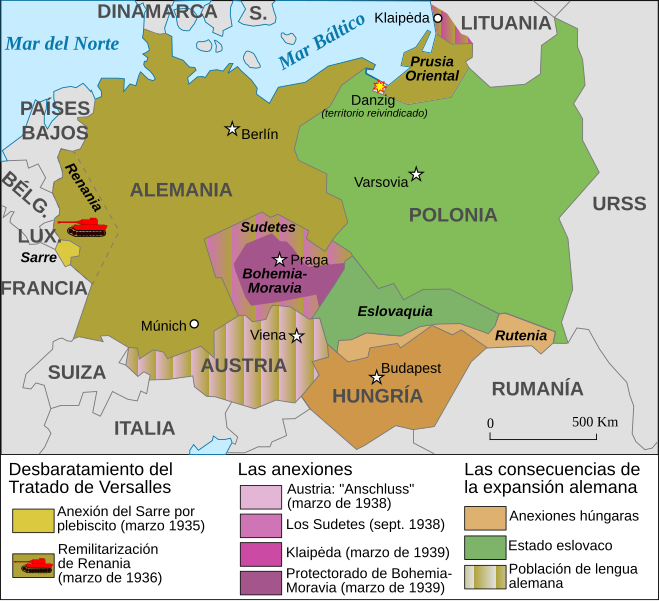
Español: Mapa de la extensión de Alemania (1935-1939) |
||||||||
| Data | |||||||||
| Fonte | Based on Image:Extension of Germany (1935-1939)-fr.svg | ||||||||
| Autor | JMPerez | ||||||||
| Permisu (Cómo reutilizar esti ficheru) |
Yo, el titular de los drechos d'autor d'esta obra, la espublizo baxo les siguientes llicencies:
Este archivo se encuentra bajo la licencia Creative Commons de Atribución/Compartir-Igual 2.5 Genérica, 2.0 Genérica y 1.0 Genérica.
Pues seleicionar la llicencia que prefieras. |
||||||||
| Otres versiones |
Français : Carte en français Image:Extension of Germany (1935-1939)-fr.svg English: French version Image:Extension of Germany (1935-1939)-fr.svg |

-es.svg)
-fr.svg)
-es.svg)
|
Esti ficheru SVG tien testu integráu que pue traducise fácilmente a la to llingua usando un editor de SVG como Inkscape o Adobe Illustrator. Ver más. Tamién pues descargalu y traducilu de mou manual usando un editor de testu. |
Historial del ficheru
Calca nuna fecha/hora pa ver el ficheru como taba daquella.
| Data/Hora | Miniatura | Dimensiones | Usuariu | Comentariu | |
|---|---|---|---|---|---|
| actual | 20:01 14 feb 2017 | | 790 × 719 (648 kB) | Rowanwindwhistler | https://en.wikipedia.org/wiki/Wikipedia:WikiProject_Maps/Conventions Fake text added Múnich |
| 16:11 5 set 2007 |  | 741 × 674 (116 kB) | Redtony | "Prusia Oriental" traducido | |
| 16:38 18 ago 2007 |  | 741 × 674 (116 kB) | JMPerez~commonswiki | {{Information |Description={{es}}Mapa de la extensión de Alemania (1935-1939) |Source=Based on Image:Extension of Germany (1935-1939)-fr.svg |Date=18/08/2007 |Author=JMPerez |Permission={{self2|GFDL|cc-by-sa-2.5,2.0,1.0}} |other_ver |
-fr.svg)
Usu del ficheru
La páxina siguiente usa esti ficheru:
Usu global del ficheru
Estes otres wikis usen esti ficheru:
- Usu en ca.wikipedia.org
- Usu en es.wikipedia.org
- Usu en gl.wikipedia.org
-es.svg)