
Ficheru:Europe 1867 map en.png
Tamañu d'esta previsualización: 800 × 526 pixels. Otres resoluciones: 320 × 211 pixels | 640 × 421 pixels | 1024 × 674 pixels | 1280 × 842 pixels | 2284 × 1503 pixels.
Ficheru orixinal (2284 × 1503 píxels, tamañu de ficheru: 1,07 MB, triba MIME: image/png)
Resume
| Descripción |
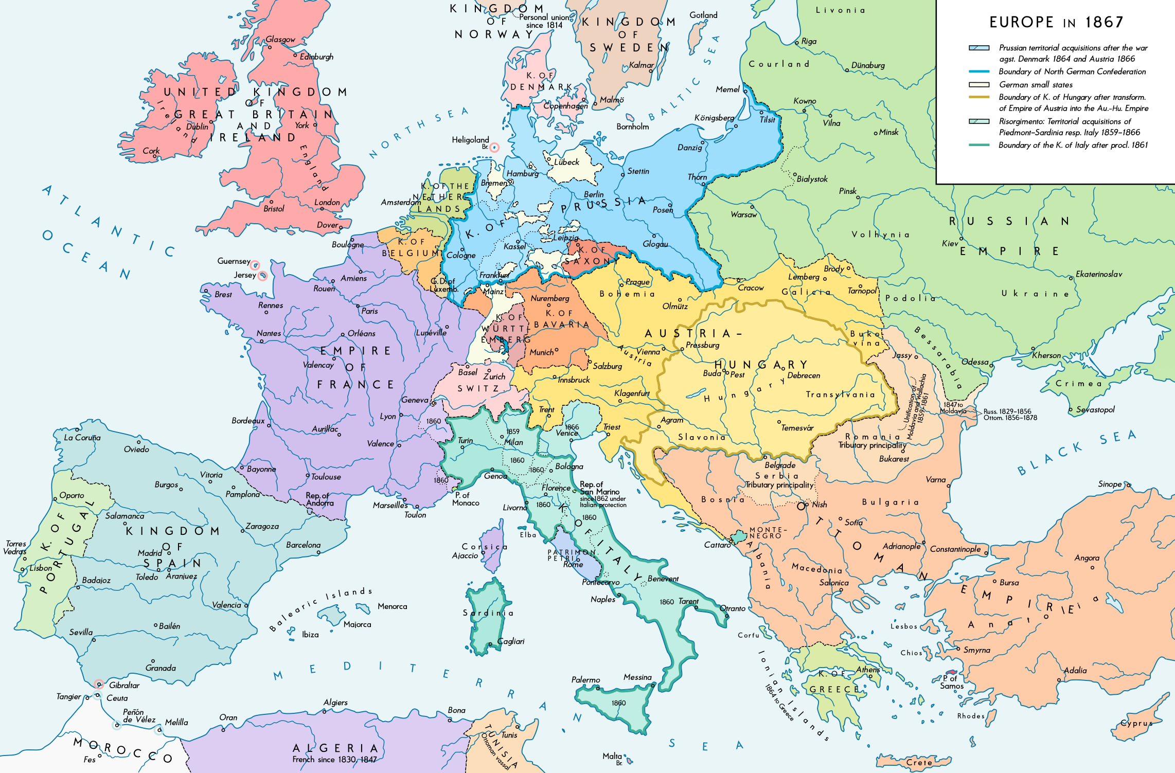
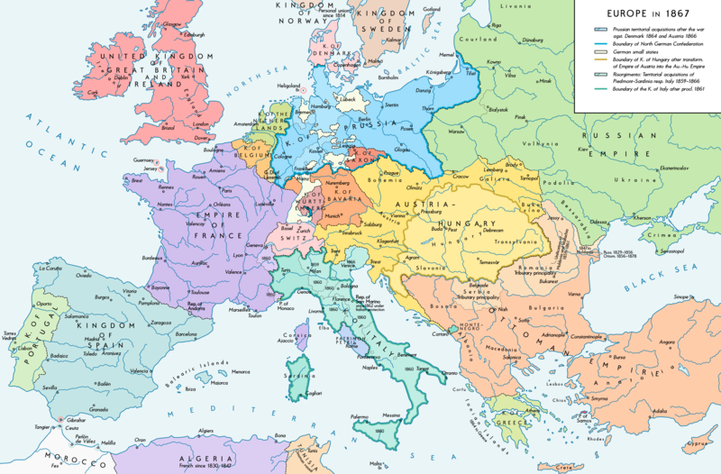
English: Europe 1867. Historical map of the political situation after the forming of the North German Confederation, the Italian Risorgimento (with the exception of the Roman part of the Papal States) and the Austro-Hungarian Compromise of 1867. Please don't alter the map, when you think there something not written or depicted correctly. Leave a message at the talk page of the file. After a verificiation and a possible discussion, i will upload a new map version with all new changes. This prevents an unnecessary waste of disc space and ensures a good result, aesthetically and contentwise. - The author. Deutsch: Europa 1867. Historische Karte der politischen Situation in Europa nach der Gründung des Norddeutschen Bundes, des italienischen Risorgimento (mit Ausnahme des röm. Teils des Kirchenstaats) und dem Österreichisch-Ungarischen Ausgleich von 1867. Bitte die Karte bei Änderungs- und Korrekturwünschen nicht selbst verändern, sondern eine Anmerkung im Diskussionsbereich der Bilddatei hinterlassen. Nach einer Prüfung und ggfs. Diskussion werden evtl. Änderungen von mir zusammengefasst eingearbeitet. Das vermeidet unnötige Speicherplatz-Verschwendung und gewährleistet ein ästhetisch ansprechendes und inhaltlich korrektes Ergebnis. - Der Urheber. |
| Data | |
| Fonte |
Trabayu propiu. Source of Information: Historical atlases and maps – Ramsay Muir, George Philip (ed.): Philip's New School Atlas of Universal History, George Philip & Son, Ltd., London 1928 – Dr. Walter Leisering (ed.): Putzger Historischer Weltatlas, Cornelsen Verlag, Berlin 1992, ISBN 3-464-00176-8 – Bayerischer Schulbuch-Verlag (ed.): Großer Historischer Weltatlas, Dritter Teil, Neuzeit, Bayerischer Schulbuch-Verlag, München 1981, ISBN 3-7627-6021-7. – Prof. Dr. Vadim Oswalt u. Prof. Dr. Hans Ulrich Rudolf (ed.): Klett-Perthes Atlas zur Weltgeschichte, Ernst Klett Verlag, Stuttgart 2011, ISBN 978-3-12-828194-0 – Ziegelbrenner: Karte des Norddeutschen Bundes 1866–1871, 6 June 2014 version (map link) Other publications – Francesco Traniello u. Gianni Sofri: Der lange Weg zur Nation. Das italienische Risorgimento, Verlag W. Kohlhammer, Stuttgart 2012, ISBN 978-3-17-021898-7 |
| Autor | Alexander Altenhof |
| Otres versiones |
|

Recompressed without quality loss with OptiPNG (1.35 MB > 1.06 MB)
Llicencia
Yo, el titular de los drechos d'autor d'esta obra, la espublizo baxo la siguiente llicencia:
Este archivo está disponible bajo la licencia Creative Commons Atribución-CompartirIgual 4.0 Internacional.
- Ye llibre:
- pa compartir – pa copiar, distribuir y comunicar públicamente la obra
- pa remezclar – p'adautar la obra
- Baxo les condiciones siguientes:
- reconocimientu – Tienes de dar el créitu apropiáu, apurrir un enllaz a la llicencia ya indicar si realizasti dalgún cambéu. Puedes faelo de cualquier mou razonable ,pero non de manera que suxera l'encontu del autor pa ti o pal usu que faigas.
- compartir igual – Si entemeces, tresformes o te bases nesti material, tienes de distribuir les tos contribuciones baxo la mesma llicencia o una compatible cola orixinal.
Historial del ficheru
Calca nuna fecha/hora pa ver el ficheru como taba daquella.
| Data/Hora | Miniatura | Dimensiones | Usuariu | Comentariu | |
|---|---|---|---|---|---|
| actual | 23:42 14 abr 2017 | | 2284 × 1503 (1,07 MB) | KaterBegemot | Empire of France (not Kingdom), changed main caption to "Europe in 1867", fixed font size of "Piedmont-Sardinia", minor changes |
| 21:36 4 set 2016 |  | 2284 × 1503 (1,06 MB) | KaterBegemot | {{Information |Description ={{en|1=Europe 1867. Historical map of the political situation after the forming of the North German Confederation, the Italian Risorgimento (with the exception of the Roman part of the Papal States) and the Austro-Hungari... |
Usu del ficheru
La páxina siguiente usa esti ficheru:
Usu global del ficheru
Estes otres wikis usen esti ficheru:
- Usu en en.wikipedia.org
- Usu en et.wikipedia.org
- Usu en it.wikipedia.org